Search Results

Map of California, and territories of Utah, Nevada, Colorado, New Mexico and Arizona, 1864
Date
1864
Description
'Johnson's California, also Utah, Nevada, Colorado, New Mexico, and Arizona, published by A.J. Johnson, New York.' 'Entered according to act of Congress in the year 1864, by A.J. Johnson in the Clerks Office of the District Court of the United States for the southern district of New York.' Atlas page numbers in upper margin: 67-68. Relief shown by hachures. Prime meridian: Greenwich and Washington. Shows natural features, locations of Indian tribes, proposed railroad routes, routes of explorers, trails, county boundaries and populated places. Hand colored. On verso: 'Historical and statistical view of the West India Islands or Columbian Archipelago' (p. 80) and 'Historical and statistical view of Mexico and Central America' (p. 79). Scale [ca. 1:3,484,800]. 1 in. to ca. 55 miles (W 124°--W 102°/N 42°--N 32°).
Text
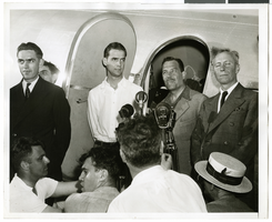
Photograph of Howard Hughes and his crew in Floyd Bennett Field, New York, July 10, 1938
Date
1938-07-10
Archival Collection
Description
The black and white view of Howard Hughes and his crew at Floyd Bennett Field in New York. Typed onto a piece of paper attached to the image: "Before Hughes hopped off for Paris. Left to right: Edward Lund, Flight Engineer, Howard Hughes, Grover Whalen, Harry Connor, Navigator and Dick Stoddard Radio Engineer. At Floyd Bennett Airport 7/10/38."
Image

Photograph of Howard Hughes and Grover Whalen at Floyd Bennett Airfield, New York, July 14, 1938
Date
1938-07-14
Archival Collection
Description
A view of Howard Hughes and Grover Whalen at Floyd Bennett Airfield in New York. Description printed on photograph's accompanying sheet of paper: "Howard Hughes leaving Floyd Bennett Airport after completing a round the world flight with four companions. He is leaving with Grover Whalen (Left in picture) 7-14-38. (Press Association)."
Image
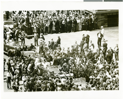
Photograph of Howard Hughes at his parade for Round the World flight, New York City, July 15, 1938
Date
1938-07-15
Archival Collection
Description
The black and white view of Howard Hughes, Mayor La Guerdia, and Grover Whalen leaving City Hall through a parade dedicated to the completion of Hughes' Round the World flight in New York City, New York.
Image
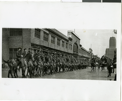
Photograph of police men awaiting the arrival of Howard Hughes, New York, July 15, 1938
Date
1938-07-15
Archival Collection
Description
Typed onto a piece of paper attached to the image: "Police lined up ready for the start of Howard Hughes parade. 7/15/38."
Image
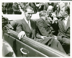
Photograph of Howard Hughes at his parade for Round the World flight, New York City, July 15, 1938
Date
1938-07-15
Archival Collection
Description
The black and white view of Howard Hughes (left) and Mayor Fiorello Laguardia (right) seated in an automobile that was used in a parade dedicated to Hughes' completion of his Round the World flight in New York City, New York.
Image
Howard Hughes talking to members of the press, possibly about his completion of his around-the-world flight in New York City, New York, 1938
Level of Description
File
Archival Collection
Howard Hughes Public Relations Photograph Collection
Archival Component
Howard Hughes and crew in parade up Broadway after record-breaking around-the-world flight New York, New York, 1938 July 15
Level of Description
File
Archival Collection
Howard Hughes Public Relations Photograph Collection
Archival Component
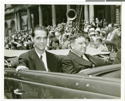
Photograph of Howard Hughes near City Hall, New York City, July 15, 1938
Date
1938-07-15
Archival Collection
Description
Typed onto a piece of paper attached to the image: "At reception for World Fliers. Howard Hughes and Mayor Fiorello Laguardia seated in their parade car as Grover Whalen enters it just before the precession gets underway. 7/15/38."
Image

Map of California, Utah, Nevada, Colorado, New Mexico and Arizona, circa 1867
Date
1865 to 1869
Description
39 x 56 cm. Relief shown by hachures. "Entered according to act of Congress in the year 1864, by A.J. Johnson in the Clerks Office of the United States for the Southern District of New York." Atlas page numbers in upper margin: 67-68. Primer meridians: Greenwich and Washington, D.C. On verso: History and statistical view of the West India islands or Columbian Archipelago and Historical and statistical view of Mexico and Central America. Shows proposed railroads, locations of Indian tribes, natural features, counties, mines, mail routes, trails and routes of exploring expeditions. Has decorative border. Southern part of Nevada was added to the state in 1867 and is part of Nevada on this map, but Lincoln County was established in 1867 and is not on this map. This map was still probably published in 1867 in spite of someone's having written "1864" in pencil in the lower right corner of the Library's copy. Original publisher: A.J. Johnson.
Image