Search Results
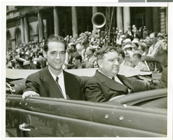
Photograph of Howard Hughes at his parade for Round the World flight, New York City, July 15, 1938
Date
1938-07-15
Archival Collection
Description
The black and white view of Howard Hughes (left) and Mayor Fiorello Laguardia (right) seated in an automobile that was used in a parade dedicated to Hughes' completion of his Round the World flight in New York City, New York.
Image
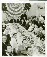
Photograph of a luncheon for the completion of Howard Hughes' Round the World flight, New York City, July 15, 1938
Date
1938-07-15
Archival Collection
Description
Typed onto a piece of paper attached to the image: "Fete, Hughes, and crew at Luncheon. Left to right at the head of the table are Harry P. Connor, navigator of the Hughes plane, Grover Whalen, Howard hughes, Mayor Fiorello Laguardia of New York City, Thomas Thurlow, Navigator, Richard Stoddart, radio engineer, and Edward Lund, flight engineer. At the bottom center of the photo is William Randolph Hearst, Jr., son of the publisher. 7/15/38"
Image
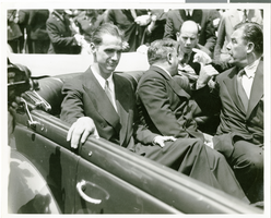
Photograph of Howard Hughes at his parade for Round the World flight, New York City, July 15, 1938
Date
1938-07-15
Archival Collection
Description
The black and white view of Howard Hughes, Mayor La Guerdia, and Grover Whalen leaving City Hall through a parade dedicated to the completion of Hughes' Round the World flight in New York City, New York.
Image

Hotel Construction: Monte Carlo, New York-New York, and Stratosphere, Culinary Union, Las Vegas (Nev.), 1996 June (folder 1 of 1), image 15
Date
1996-06
Description
Arrangement note: Series III. Internal: Work
Image
Unknown author. For High Rollers Only, New York Times Magazine, 1976 November 15
Level of Description
File
Archival Collection
UNLV Libraries Collection of Articles on Gaming and Las Vegas, Nevada Topics
Archival Component

Geologic map of the northeast quarter of the Bullfrog 15-minute quadrangle, Nye County, Nevada, 1990
Date
1990
Description
58 x 46 cm., on sheet 87 x 102 cm., folded in envelope 30 x 24 cm. Relief shown by contours and spot heights. "Contour interval 40 feet." "Base from U.S. Geological Survey 1:62,500. 1954." "Geology mapped in 1985 and 1988." Includes text, bibliography, 4 col. cross sections, and location and index maps. "Prepared in cooperation with the U. S. Atomic Commission." Original publisher: U. S. Geological Survey, Series: Miscellaneous investigations series, map I, Scale: 1:24 000.
Image
New York New York Hotel and Casino: postcards
Date
1997
Archival Collection
Description
Postcards of New York New York Hotel and Casino. (1997)
Image
#68073: Men's Football - New Players (Individuals), Coaches for Media Guides, 2011 May 15
Level of Description
File
Archival Collection
University of Nevada, Las Vegas Creative Services Records (2010s)
Archival Component
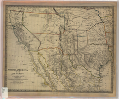
Map of Utah, New Mexico, Texas, California, Indian territory, and the northern states of Mexico, 1852
Date
1852-01-01
Description
At head of title: 'North America, sheet XV.' 'Published under the superintendence of the Society for Diffusion of Useful Knowledge.' At bottom center of map:'London, Charles Knight, Jany. 1st, 1852.' At bottom right of map: ' J. & C. Walker Sculpt.' Scale [1:7,500,000] 1 degree to 68.89 English miles (W 125°--W 92°/N 43°30?--N 22°30?). Relief shown by hachures. Atlas page number in lower margin: 144. Boundaries hand colored. Includes notes, locations of Indian tribes, population statistics. Charles Knight.
Image
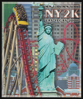
New York New York Hotel and Casino: postcards
Date
1997 to 2000
Archival Collection
Description
Postcards of New York New York Hotel and Casino, Las Vegas, NV. (Opened January 3, 1997) (1997-2000)
Image