Search Results

The MGM Grand Hotel in Reno, Nevada: postcard
Date
1940 (year approximate) to 1990 (year approximate)
Archival Collection
Description
From the Harvey's Hotel and Casino Postcard Collection (PH-00367) -- MGM Grand Hotel in Reno, Nevada.
Image

The Sahara Hotel and Casino in Reno, Nevada: postcard
Date
1940 (year approximate) to 1990 (year approximate)
Archival Collection
Description
From the Harvey's Hotel and Casino Postcard Collection (PH-00367) -- A collage of pictures of the Sahara in Reno, Nevada.
Image
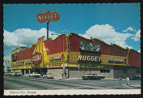
The Nugget Casino in Carson City, Nevada: postcard
Date
1940 (year approximate) to 1990 (year approximate)
Archival Collection
Description
From the Harvey's Hotel and Casino Postcard Collection (PH-00367) -- The Nugget Casino in Carson City, Nevada.
Image
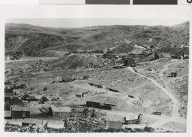
Photograph of Candelaria, Nevada, 1876
Date
1876
Archival Collection
Description
Black and white photograph of Candelaria.
Image
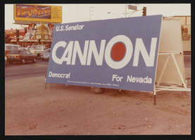
Cannon for Nevada campaign sign in Las Vegas, Nevada: photographic print
Date
1982-03
Archival Collection
Description
From the Howard Cannon Photograph Collection (PH-00192). Cannon for Nevada campaign sign located possibly at the intersection of Sahara Boulevard and Las Vegas Boulevard.
Image
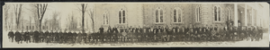
Nevada Legislature in Carson City, Nevada: photographic print
Date
1923
Archival Collection
Description
From the Albert S. Henderson Photograph Collection (PH-00317).
Image
Nevada Southern University and University of Nevada, Las Vegas
Level of Description
File
Archival Collection
Archie C. Grant Photograph Collection
To request this item in person:
Collection Number: PH-00016
Collection Name: Archie C. Grant Photograph Collection
Box/Folder: N/A
Collection Name: Archie C. Grant Photograph Collection
Box/Folder: N/A
Archival Component
Meeting minutes for Consolidated Student Senate University of Nevada, Las Vegas, October 26, 1989
Date
1989-10-26
Archival Collection
Description
Includes meeting agenda and minutes. CSUN Session 19 Meeting Minutes and Agendas.
Text
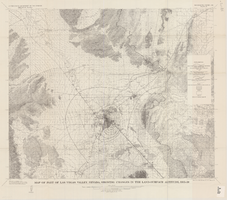
Map of part of Las Vegas Valley, Nevada, showing changes in the land-surface altitude, 1935-50
Date
1965
Description
Genre/Form: Topographic maps. Scale 1:96,000 (W 115°30´--W 114°45´/N 36°30´--N 36°00´). 1 map ; 58 x 70 cm. Series: Water-supply paper (Washington, D.C.) ; 1780. Relief shown by contours. "After Smith, Vetter, Cummings, and others (1960, p. 34)." Originally published as plate 13 of Available water supply of the Las Vegas ground-water basin, Nevada, by Glenn T. Malmberg, published by the Geological Survey in 1965 as its Water-supply paper 1780. Includes township and range lines. Interior, Geological Survey
Image
Political History of Nevada, Secretary of State of Nevada, 1965
Level of Description
File
Archival Collection
Eileen Brookman Papers
To request this item in person:
Collection Number: MS-00620
Collection Name: Eileen Brookman Papers
Box/Folder: Box 09
Collection Name: Eileen Brookman Papers
Box/Folder: Box 09
Archival Component