Search Results
Howard Cannon presents the Clark County Community College outstanding Classified Staff member of the 1980-1981 Academic Year Award to Bernice McKnight: photographic print, 1981 May
Level of Description
Archival Collection
Collection Name: Howard Cannon Photograph Collection
Box/Folder: Folder 19
Archival Component
Bibliography of U.S. Geological Survey Unclassified Reports of Investigations at Nuclear Test Site in the United States, Fiscal Year 1963 - United States Department of the Interior, Geological Survey, 1963
Level of Description
Archival Collection
Collection Name: Yucca Mountain Site Characterization Office Collection
Box/Folder: Box 77
Archival Component
Conrad, Robert; Brookhaven National Laboratory. A Twenty Year Review of Medical Findings in a Marshallese Population Accidentally Exposed to Radioactive Fallout. Upton, NY: Brookhaven National Laboratory, 1975
Level of Description
Archival Collection
Collection Name: Alice P. Broudy Papers on Broudy v. United States
Box/Folder: Box 10
Archival Component
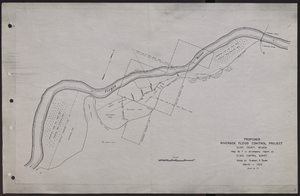
Map of proposed flood control project on the Virgin River in Clark County, Nevada, March, 1934
Date
Archival Collection
Description
Image
Don Schuyler Sr., about 17 years old, in front of Clark County High School, in Clark County sweater, riding boots, and pants: photographic print, approximately 1922
Level of Description
Archival Collection
Collection Name: Schuyler Family Photograph Collection
Box/Folder: Digital File 00
Archival Component
Essex-Diamond Ore Research Program: Essex VI - Effects of Low-Yield Nuclear Explosions on Airfields and Railway Systems Calendar Year 1973 Experimental Effort, 1975 September
Level of Description
Archival Collection
Collection Name: Yucca Mountain Site Characterization Office Collection
Box/Folder: Box 34
Archival Component

Topographic map of Nevada-California, Las Vegas quadrangle, March 1908
Date
Description
'Edition of Mar. 1908.' 'E.M. Douglas, geographer in charge; Topography and triangulation by R.H. Chapman, B.D. Stewart, J.E. Blackburn, and D.F.C. Moor. Surveyed in 1906-1907.' Scale 1:250,000 (W 116°00--W 115°00/N 37°00--N 36°00). Relief shown by contours and spot heights. Title in lower-right corner: Las Vegas. Contour interval 100 feet. Datum is mean sea level. "Topography"--Center of top margin. Text about the Topographic Maps of the United States series and symbols used on map on verso. U.S. Geological Survey
Text
T-Shirt Color: Blue; Front: 05; Handwritten Text: August 11th 2002, 8 Years Old, Milwaukee Wisconsin, Brittany Loves Las Vegas, approximately 2001-2012
Level of Description
Archival Collection
Collection Name: New York-New York Hotel and Casino 9-11 Heroes Tribute Collection
Box/Folder: Box 119
Archival Component
T-Shirt Color: Navy Blue; Front: Volunteers For 50 Years, Chugiak Fire And Rescue 1952-2002, Alaska, Dept. Emblem; Back: Fire Rescue, approximately 2001-2012
Level of Description
Archival Collection
Collection Name: New York-New York Hotel and Casino 9-11 Heroes Tribute Collection
Box/Folder: Box 28
Archival Component
Clark County Transportation Study; Transportation Systems Management Element - Fiscal years 1981 Through 1983 by Clark County Transportation Study Policy Committee, approximately 1981 to 1983
Level of Description
Archival Collection
Collection Name: Clark County Planning Commission Research Library Collection
Box/Folder: Box 52
Archival Component