Search Results
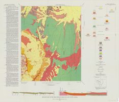
Geologic map of the Trail Ridge quadrangle, Nye County, Nevada, 1968
Date
Description
Image

Topographic map of Goodsprings quadrangle, Nevada and California, 1919
Date
Description
Text
Centennial Stories: A Leap Back, A Look Forward-100 Years of History-The Strip, CCTV-4 Clark County TV, 2009
Level of Description
Archival Collection
Collection Name: Scott Rayer Collection of Television Programs about Las Vegas, Nevada
Box/Folder: Digital File 00
Archival Component
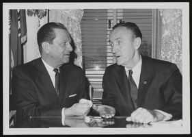
Howard Cannon and Senate Majority Leader Mike Mansfield meeting to plan the development of 150 million new silver dollars within the year: photographic print
Date
Archival Collection
Description
Image
Las Vegas Valley Water District: "Leaders in Service, Comprehensive Annual Financial Report for the Year Ended June 30, 1998", 1998 December 07
Level of Description
Archival Collection
Collection Name: Bruce Turner Collection on Transportation and Water in Southern Nevada
Box/Folder: Box 12
Archival Component
Las Vegas Valley Water District: "Leaders in Service, Comprehensive Annual Financial Report for the Year Ended June 30, 1996", 1996 November 27
Level of Description
Archival Collection
Collection Name: Bruce Turner Collection on Transportation and Water in Southern Nevada
Box/Folder: Box 12
Archival Component
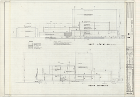
Architectural drawings of Fine Arts Building, University of Nevada Southern Regional Branch, Las Vegas, Nevada, east and north exterior elevations, July 15, 1963
Date
Archival Collection
Description
East and north exterior elevations of the Fine Arts Building (later to become the Judy Bayley Theatre) at the University of Nevada Southern Regional Branch, Las Vegas, Nevada (later University of Nevada, Las Vegas). Scale: 1/8" = 1'-0". "Sheet A-9 of 26." "Drawn: JM. Checked: JBM. Date 10 July 63. Submittal dates: preliminary 12-7-62; intermediate 3-17-63; final 7-15-63." "Bolt , Beranek and Newman Inc., consultants in acoustics. D'autremont-Helms & Assoc., consulting mechanical engineers. Helin Engineering Co., electrical engineers." "Fund code no. 82301." "State of Nevada Planning Board, Carson City, Nevada."
Site Name: University of Nevada. Southern Regional Division
Address: 4505 S. Maryland Parkway
Image
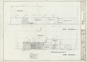
Architectural drawings of Fine Arts Building, University of Nevada Southern Regional Branch, Las Vegas, Nevada, west and south exterior elevations, July 15, 1963
Date
Archival Collection
Description
West and south exterior elevations of the Fine Arts Building (later to become the Judy Bayley Theatre) at the University of Nevada Southern Regional Branch, Las Vegas, Nevada (later University of Nevada, Las Vegas). Scale: 1/8" = 1'-0". "Sheet A-10 of 26." "Drawn: JM. Checked: JBM. Date 10 July 63. Submittal dates: preliminary 12-7-62; intermediate 3-17-63; final 7-15-63." "Bolt , Beranek and Newman Inc., consultants in acoustics. D'Autremont-Helms & Assoc., consulting mechanical engineers. Helin Engineering Co., electrical engineers." "Fund code no. 82301." "State of Nevada Planning Board, Carson City, Nevada."
Site Name: University of Nevada. Southern Regional Division
Address: 4505 S. Maryland Parkway
Image
#62470: 10 Year Portraits - Picone, Rick; Lewis, Jim; Reed, Phil; Bellino, Debbie; Atkinson, Rick; Carter Geroy, 1999 November 03
Level of Description
Archival Collection
Collection Name: University of Nevada, Las Vegas Creative Services Records (1990s)
Box/Folder: N/A
Archival Component
"The Wandering Moses 40 years in the desert." The postcard shows a man with a pack mule and several men standing behind him: postcard, approximately 1900-1915
Level of Description
Archival Collection
Collection Name: C. A. Earle Rinker Photograph Collection of Goldfield, Nevada
Box/Folder: Folder 03
Archival Component