Search Results
City of Las Vegas Five Year Capital Improvement Plan, Las Vegas Metropolitan Police Department final budget, 2016 to 2020
Level of Description
File
Archival Collection
Bob Coffin Political Papers
To request this item in person:
Collection Number: MS-01054
Collection Name: Bob Coffin Political Papers
Box/Folder: Box 104
Collection Name: Bob Coffin Political Papers
Box/Folder: Box 104
Archival Component
Jany Ortiz's "Senior Year" scrapbook with photographs, newspaper clippings, notes, "M" letter for varsity jacket, personal notes, and ephemera, 1984 to 1985
Level of Description
File
Archival Collection
Jany Ortiz-Robinson Papers
To request this item in person:
Collection Number: MS-01199
Collection Name: Jany Ortiz-Robinson Papers
Box/Folder: Box 02
Collection Name: Jany Ortiz-Robinson Papers
Box/Folder: Box 02
Archival Component
The Gentleman's Diary, or, the mathematical repository; an almanac for the year of our Lord 1823. London: printed for the Company of Stationers by J. Nichols, 1823
Level of Description
Item
Archival Collection
Mavis Eggle "Books as They Were Bought" Collection
To request this item in person:
Collection Number: MS-01144
Collection Name: Mavis Eggle "Books as They Were Bought" Collection
Box/Folder: Box 26
Collection Name: Mavis Eggle "Books as They Were Bought" Collection
Box/Folder: Box 26
Archival Component
Awards and honors: Greater Las Vegas Chamber of Commerce EPY (Entertainment Personality of the Year) award, press clippings and programs, 1976 January
Level of Description
File
Archival Collection
Donn Arden Papers
To request this item in person:
Collection Number: MS-00425
Collection Name: Donn Arden Papers
Box/Folder: Box 1
Collection Name: Donn Arden Papers
Box/Folder: Box 1
Archival Component
Harley E. Harmon, 4 years old, standing in front of a house on a Easter Sunday, reproduction of image from approximately 1922: photographic print, 1951
Level of Description
Item
Archival Collection
Harmon Family Photograph Collection
To request this item in person:
Collection Number: PH-00182
Collection Name: Harmon Family Photograph Collection
Box/Folder: Folder 01
Collection Name: Harmon Family Photograph Collection
Box/Folder: Folder 01
Archival Component
A man dressed as Lawrence of Arabia on horseback advertising "The best picture of the year: Lawrence of Arabia at the Guild Theatre May 22", 1960-1963
Level of Description
File
Archival Collection
Edythe and Lloyd Katz Photographs
To request this item in person:
Collection Number: PH-00250
Collection Name: Edythe and Lloyd Katz Photographs
Box/Folder: Folder 03
Collection Name: Edythe and Lloyd Katz Photographs
Box/Folder: Folder 03
Archival Component
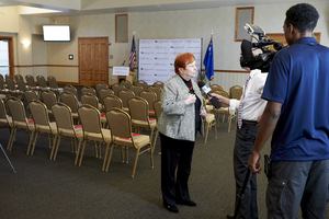
An event to mark a $3 million grant spanning five years from the United Health Foundation to the UNLV School of Medicine for building research programs and helping build three community clinics: digital photographs
Date
2016-04-05
Archival Collection
Description
Photographs from the University of Nevada, Las Vegas Creative Services Records (2010s) (PH-00388-05).
Image
Hoover Dam First 50 Years; Silver Cup hydro races on Lake Mead; Channel 3 news of Hoover Dam, 1985 to 1986
Level of Description
File
Archival Collection
Gene Hertzog Professional Papers
To request this item in person:
Collection Number: MS-01015
Collection Name: Gene Hertzog Professional Papers
Box/Folder: Box 20
Collection Name: Gene Hertzog Professional Papers
Box/Folder: Box 20
Archival Component
Howard Cannon presents to Malvin Matthews the American Training Association Million Miles Driver of the Year Award: photographic print, 1980 February
Level of Description
Item
Archival Collection
Howard Cannon Photograph Collection
To request this item in person:
Collection Number: PH-00192
Collection Name: Howard Cannon Photograph Collection
Box/Folder: Folder 17
Collection Name: Howard Cannon Photograph Collection
Box/Folder: Folder 17
Archival Component
Spent Fuel Test-Climax: Technical Measurements Interim Report, Fiscal Year 82 - Lawrence Livermore National Laboratory, 1983 December
Level of Description
File
Archival Collection
Yucca Mountain Site Characterization Office Collection
To request this item in person:
Collection Number: MS-00091
Collection Name: Yucca Mountain Site Characterization Office Collection
Box/Folder: Box 74
Collection Name: Yucca Mountain Site Characterization Office Collection
Box/Folder: Box 74
Archival Component