Search Results

Map of Las Vegas, Nevada and surrounding Bureau of Land Management areas to the west and north, 1994
Date
1994
Description
'BLM edition, 1994.' 'Surface management status; mineral management status.' '1:100,000-scale topographic map showing highways, roads and other manmade structures; water features; contours and elevations in meters with conversions to feet; BLM recreation sites.' 'Edited and published by the Bureau of Land Management. Base map prepared by the U.S. Geological Survey.' I53:11/4-2
Text
#68635: Christina Hernandez, Outreach & Awareness Coordinator at the Jean Nidetch Women's Center, professional staff member of the year., 2012 May
Level of Description
File
Archival Collection
University of Nevada, Las Vegas Creative Services Records (2010s)
To request this item in person:
Collection Number: PH-00388-05
Collection Name: University of Nevada, Las Vegas Creative Services Records (2010s)
Box/Folder: Digital File 00
Collection Name: University of Nevada, Las Vegas Creative Services Records (2010s)
Box/Folder: Digital File 00
Archival Component
#71526: Engelstad Scholars End of the Year Celebration at the Blasco Event Wing of the Foundations Building, April 28, 2017, 2017 April 28
Level of Description
Item
Archival Collection
University of Nevada, Las Vegas Creative Services Records (2010s)
To request this item in person:
Collection Number: PH-00388-05
Collection Name: University of Nevada, Las Vegas Creative Services Records (2010s)
Box/Folder: Digital File 01
Collection Name: University of Nevada, Las Vegas Creative Services Records (2010s)
Box/Folder: Digital File 01
Archival Component
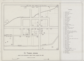
Map of St. Thomas, Nevada, circa 1933
Date
1930 to 1933
Archival Collection
Description
Hand-drawn map of St. Thomas, Nevada (ca. 1914-1932) which was abandoned in 1933 due to the construction of Hoover Dam and is now covered by Lake Mead, as remembered by Merle Frehner (a former resident of St.Thomas). Buildings and residences on map are numbered and explained in a key. "Mormon plat assumed." Scale: 1 1/2 in. = 300 ft.
Image
#70458: Hannah Birch, alumna of the year for Greenspun College of Urban Affairs taken September 3, 2015 in New York., 2015 September 08
Level of Description
File
Archival Collection
University of Nevada, Las Vegas Creative Services Records (2010s)
To request this item in person:
Collection Number: PH-00388-05
Collection Name: University of Nevada, Las Vegas Creative Services Records (2010s)
Box/Folder: Digital File 00
Collection Name: University of Nevada, Las Vegas Creative Services Records (2010s)
Box/Folder: Digital File 00
Archival Component
#69071: The annual 25 Year Club breakfast held inside Tam Alumni Center on April 11, 2013, 2013 April 11
Level of Description
File
Archival Collection
University of Nevada, Las Vegas Creative Services Records (2010s)
To request this item in person:
Collection Number: PH-00388-05
Collection Name: University of Nevada, Las Vegas Creative Services Records (2010s)
Box/Folder: Digital File 00
Collection Name: University of Nevada, Las Vegas Creative Services Records (2010s)
Box/Folder: Digital File 00
Archival Component
#69809: Liz Smith, Geoscience Administrative Assistant III and President's Classified Employee of the Year on July 22, 2014, 2014 July 22
Level of Description
File
Archival Collection
University of Nevada, Las Vegas Creative Services Records (2010s)
To request this item in person:
Collection Number: PH-00388-05
Collection Name: University of Nevada, Las Vegas Creative Services Records (2010s)
Box/Folder: Digital File 00
Collection Name: University of Nevada, Las Vegas Creative Services Records (2010s)
Box/Folder: Digital File 00
Archival Component
#70757: Las Vegas City Councilman Ricki Barlow, Urban Affairs Alumnus of the Year on March 17, 2016., 2016 March 17
Level of Description
File
Archival Collection
University of Nevada, Las Vegas Creative Services Records (2010s)
To request this item in person:
Collection Number: PH-00388-05
Collection Name: University of Nevada, Las Vegas Creative Services Records (2010s)
Box/Folder: Digital File 00
Collection Name: University of Nevada, Las Vegas Creative Services Records (2010s)
Box/Folder: Digital File 00
Archival Component
72 Years in Las Vegas: Las Vegas Centennial grant files and publication information, 2013 to 2014
Level of Description
File
Archival Collection
Women of Diversity Productions, Inc. Records
To request this item in person:
Collection Number: MS-01161
Collection Name: Women of Diversity Productions, Inc. Records
Box/Folder: Box 02
Collection Name: Women of Diversity Productions, Inc. Records
Box/Folder: Box 02
Archival Component
Awards and honors: Greater Las Vegas Chamber of Commerce EPY (Entertainment Personality of the Year) award, press clippings and programs, 1976 January
Level of Description
File
Archival Collection
Donn Arden Papers
To request this item in person:
Collection Number: MS-00425
Collection Name: Donn Arden Papers
Box/Folder: Box 1
Collection Name: Donn Arden Papers
Box/Folder: Box 1
Archival Component