Search Results

Map of California, Utah, Nevada, Colorado, New Mexico and Arizona, 1864
Date
1864
Description
'Johnson's California, also Utah, Nevada, Colorado, New Mexico, and Arizona, published by A.J. Johnson, New York.' 'Entered according to Act of Congress in the Year 1864, by A.J. Johnson in the Clerks Office of the District Court of the United States for the Southern District of New York.' Atlas page numbers in upper margin: 66-67. Relief shown by hachures. Prime meridians: Greenwich and Washington, D.C. Shows proposed railroads, locations of Indian tribes, natural features, counties, mines, mail routes, trails and routes of exploring expeditions. On verso: History and statistics of Mexico and Central America and statistics of national finances and the Post Office of the United States, 1860. Scale [ca. 1:3,484,800. 1 in. to ca. 55 miles] (W 123°--W 103°/N 42°--N 32°)
Text
Mineral Resources of the United States for calendar year 1910, part 1 Department of the Interior U.S. Geological Survey, 1911
Level of Description
Item
Archival Collection
Raymond Brooks Papers on Mining
To request this item in person:
Collection Number: MS-01153
Collection Name: Raymond Brooks Papers on Mining
Box/Folder: Box 04
Collection Name: Raymond Brooks Papers on Mining
Box/Folder: Box 04
Archival Component
Mineral Resources of the United States for calendar year 1910, part 2 Department of the Interior U.S. Geological Survey, 1911
Level of Description
Item
Archival Collection
Raymond Brooks Papers on Mining
To request this item in person:
Collection Number: MS-01153
Collection Name: Raymond Brooks Papers on Mining
Box/Folder: Box 05
Collection Name: Raymond Brooks Papers on Mining
Box/Folder: Box 05
Archival Component
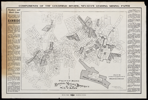
Map of Rawhide Mining District, Nevada, circa 1908
Date
1905 to 1911
Description
'Numbers and black lines show locations of the principal mines, prospects and leases of Rawhide.' 'Compiled by Engraving Department of the Goldfield Review. Olmstead and Rich, Mining Engineers, Goldfield, Nevada.' At top of map: 'Compliments of the Goldfield Review, Nevada's leading mining paper.' Includes index. Published by Goldfield Review Press.
Text
1818: This Year Thou Shalt Die!!! by the Rev. James Churchill. London: printed by W. Tew for D. Cox, approximately 1818
Level of Description
Item
Archival Collection
Mavis Eggle "Books as They Were Bought" Collection
To request this item in person:
Collection Number: MS-01144
Collection Name: Mavis Eggle "Books as They Were Bought" Collection
Box/Folder: Box 27
Collection Name: Mavis Eggle "Books as They Were Bought" Collection
Box/Folder: Box 27
Archival Component
E. T. "Pappy" Rider, 85 year old United States Postal Service mail carrier at work: photographic negatives, 1990 February
Level of Description
File
Archival Collection
Wayne C. Kodey Photographs
To request this item in person:
Collection Number: PH-00467
Collection Name: Wayne C. Kodey Photographs
Box/Folder: Box 09
Collection Name: Wayne C. Kodey Photographs
Box/Folder: Box 09
Archival Component
Bundy, McGeorge. Danger and Survival: Choices about the Bomb in the First Fifty Years. New York, NY: Random House, 1977
Level of Description
Item
Archival Collection
Alice P. Broudy Papers on Broudy v. United States
To request this item in person:
Collection Number: MS-00097
Collection Name: Alice P. Broudy Papers on Broudy v. United States
Box/Folder: Box 2
Collection Name: Alice P. Broudy Papers on Broudy v. United States
Box/Folder: Box 2
Archival Component
Arnold Schwarzenegger, accompanied by Maria Shriver, receiving VSDA's Video Star of the Year award: photographic negatives, 1990 August 08
Level of Description
File
Archival Collection
Wayne C. Kodey Photographs
To request this item in person:
Collection Number: PH-00467
Collection Name: Wayne C. Kodey Photographs
Box/Folder: Box 09
Collection Name: Wayne C. Kodey Photographs
Box/Folder: Box 09
Archival Component
Annual Budget; Fiscal Year 1985 - 86 by City of Las Vegas, Department of Finance & Computer Services, 1985 to 1986
Level of Description
File
Archival Collection
Clark County Planning Commission Research Library Collection
To request this item in person:
Collection Number: MS-01027
Collection Name: Clark County Planning Commission Research Library Collection
Box/Folder: Box 83
Collection Name: Clark County Planning Commission Research Library Collection
Box/Folder: Box 83
Archival Component
Annual Budget; Fiscal Year 1986 - 87 by City of Las Vegas, Department of Finance & Computer Services, 1986 to 1987
Level of Description
File
Archival Collection
Clark County Planning Commission Research Library Collection
To request this item in person:
Collection Number: MS-01027
Collection Name: Clark County Planning Commission Research Library Collection
Box/Folder: Box 85
Collection Name: Clark County Planning Commission Research Library Collection
Box/Folder: Box 85
Archival Component