Search the Special Collections and Archives Portal
Search Results

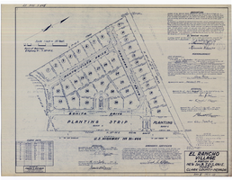
Plat map of El Rancho Village, Clark County, Nevada, July 28, 1942
Date
1942-07-28
Description
Map of housing subdivision outside the Las Vegas city limits. 'Approved this 28 day of July1942, by the City Planning Commission of the City of Las Vegas, County of Clark, Nevada. Approved this 28 day of July 1942, by the County Planning Commission of the County of Clark, State of Nevada.' Blueline print. Oriented with north to the upper right. Embossed with Engineering Certificate seal of Frank D. Rathburn, which states. 'Survey completed August 4, 1942.' 'Book II, page 53' hand printed in lower right corner. Signed by Clark County, Nevada Notary Public and other coumty officials and officials of El Rancho Village. Published by Office of F.D. Rathbun. Scale [ca. 1:600]. 1 inch to 50 feet
Text
T-Shirt Color: Blue; Front: 05; Handwritten Text: August 11th 2002, 8 Years Old, Milwaukee Wisconsin, Brittany Loves Las Vegas, approximately 2001-2012
Level of Description
File
Archival Collection
New York-New York Hotel and Casino 9-11 Heroes Tribute Collection
To request this item in person:
Collection Number: MS-00459
Collection Name: New York-New York Hotel and Casino 9-11 Heroes Tribute Collection
Box/Folder: Box 119
Collection Name: New York-New York Hotel and Casino 9-11 Heroes Tribute Collection
Box/Folder: Box 119
Archival Component
T-Shirt Color: Navy Blue; Front: Volunteers For 50 Years, Chugiak Fire And Rescue 1952-2002, Alaska, Dept. Emblem; Back: Fire Rescue, approximately 2001-2012
Level of Description
File
Archival Collection
New York-New York Hotel and Casino 9-11 Heroes Tribute Collection
To request this item in person:
Collection Number: MS-00459
Collection Name: New York-New York Hotel and Casino 9-11 Heroes Tribute Collection
Box/Folder: Box 28
Collection Name: New York-New York Hotel and Casino 9-11 Heroes Tribute Collection
Box/Folder: Box 28
Archival Component
Clark County Transportation Study; Transportation Systems Management Element - Fiscal years 1981 Through 1983 by Clark County Transportation Study Policy Committee, approximately 1981 to 1983
Level of Description
File
Archival Collection
Clark County Planning Commission Research Library Collection
To request this item in person:
Collection Number: MS-01027
Collection Name: Clark County Planning Commission Research Library Collection
Box/Folder: Box 52
Collection Name: Clark County Planning Commission Research Library Collection
Box/Folder: Box 52
Archival Component
Clark County Transportation Study; Transportation Systems Management Element - Fiscal years 1980 Through 1982 by Clark County Transportation Study Policy Committee, approximately 1980 to 1982
Level of Description
File
Archival Collection
Clark County Planning Commission Research Library Collection
To request this item in person:
Collection Number: MS-01027
Collection Name: Clark County Planning Commission Research Library Collection
Box/Folder: Box 52
Collection Name: Clark County Planning Commission Research Library Collection
Box/Folder: Box 52
Archival Component

Southern Nevada Photo Album, image 006
Description
Imperial Valley Band. El Centro, California, ca. 1925.

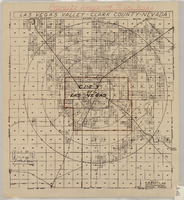
Map showing proposed annexation of Las Vegas Valley, Clark County, Nevada, January 1, 1929
Date
1929-01-01
Description
'Compiled by C. D. Baker, C.E., United States Mineral Surveyor, State Right Water Surveyor, Nevada. Las Vegas, Nev. January 1, 1929. Copyright applied for.' ; "Filed Dec. 10, 1936" and signed by Viola Burns, clerk, city of Las Vegas ; Hand-printed title at top of map: Proposed annexation to Las Vegas ; Map is stamped as Filed Dec 10, 1936 and signed by Las Vegas City Clerk Viola Burns. Library's copy has brown line hand-drawn around area to be annexed.
Image
Clark County, Nevada Financial Reports
Identifier
MS-00670
Abstract
The Clark County, Nevada Financial Reports (1974-1982) include yearly financial reports prepared by the Office of the Comptroller.
Archival Collection

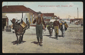
"A typical prospector's outfit, Tonopah, Nevada": postcard
Date
1900 (year approximate) to 1915 (year approximate)
Archival Collection
Description
Tinted postcard titled "A typical prospector's outfit, Tonopah, Nevada."
Image

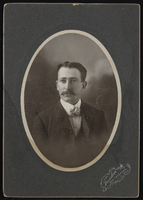
People outside in Goldfield and Tonopah, Nevada: photographic prints
Date
1900 (year approximate) to 1902 (year approximate)
Archival Collection
Description
From the Nevada Mining Photograph Collection (PH-00361).
Image
Pagination
Refine my results
Content Type
Creator or Contributor
Subject
Archival Collection
Digital Project
Resource Type
Year
Material Type
Place
Language
Records Classification
