Search the Special Collections and Archives Portal
Search Results

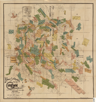
Map of the Goldfield Mining District, Nye and Esmeralda Counties, Nevada, 1905
Date
1905
Description
Copyright 1905 by Elmer J. Chute, E.M. Goldfield, Nev. In lower right corner: "Designed and drawn by R.W. Griswold." Includes inset location map; Includes township and range grid. Scale [ca. 1:20, 400. 1 in.=aprrox. 1,700 feet]
Image
The Italian Benevolent Society and the Home for Aged Poor Fund, ball and supper, menu, The Monico, International Hall, 1900 March 07
Level of Description
Item
Archival Collection
Bohn-Bettoni Menu Collection
To request this item in person:
Collection Number: MS-00793
Collection Name: Bohn-Bettoni Menu Collection
Box/Folder: Box 06
Collection Name: Bohn-Bettoni Menu Collection
Box/Folder: Box 06
Archival Component
#70757: Las Vegas City Councilman Ricki Barlow, Urban Affairs Alumnus of the Year on March 17, 2016., 2016 March 17
Level of Description
File
Archival Collection
University of Nevada, Las Vegas Creative Services Records (2010s)
To request this item in person:
Collection Number: PH-00388-05
Collection Name: University of Nevada, Las Vegas Creative Services Records (2010s)
Box/Folder: Digital File 00
Collection Name: University of Nevada, Las Vegas Creative Services Records (2010s)
Box/Folder: Digital File 00
Archival Component
May Wheeler Bradford’s collection of Chinese artifacts, pre-Boxer rebellion, 1899-1900: photographic print, 1977 July
Level of Description
Item
Archival Collection
Nan Doughty Photograph Collection
To request this item in person:
Collection Number: PH-00240
Collection Name: Nan Doughty Photograph Collection
Box/Folder: Folder 18
Collection Name: Nan Doughty Photograph Collection
Box/Folder: Folder 18
Archival Component
Union Pacific Railroad supporting infrastructure and facilities: contains architectural and structural drawings of turntables and store houses in Los Angeles, California, 1919 June 17-1925 March 20
Level of Description
File
Archival Collection
Union Pacific Railroad Collection
To request this item in person:
Collection Number: MS-00397
Collection Name: Union Pacific Railroad Collection
Box/Folder: Flat File 187
Collection Name: Union Pacific Railroad Collection
Box/Folder: Flat File 187
Archival Component

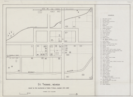
Map of St. Thomas, Nevada, circa 1933
Date
1930 to 1933
Archival Collection
Description
Hand-drawn map of St. Thomas, Nevada (ca. 1914-1932) which was abandoned in 1933 due to the construction of Hoover Dam and is now covered by Lake Mead, as remembered by Merle Frehner (a former resident of St.Thomas). Buildings and residences on map are numbered and explained in a key. "Mormon plat assumed." Scale: 1 1/2 in. = 300 ft.
Image
72 Years in Las Vegas: Las Vegas Centennial grant files and publication information, 2013 to 2014
Level of Description
File
Archival Collection
Women of Diversity Productions, Inc. Records
To request this item in person:
Collection Number: MS-01161
Collection Name: Women of Diversity Productions, Inc. Records
Box/Folder: Box 02
Collection Name: Women of Diversity Productions, Inc. Records
Box/Folder: Box 02
Archival Component
Awards and honors: Greater Las Vegas Chamber of Commerce EPY (Entertainment Personality of the Year) award, press clippings and programs, 1976 January
Level of Description
File
Archival Collection
Donn Arden Papers
To request this item in person:
Collection Number: MS-00425
Collection Name: Donn Arden Papers
Box/Folder: Box 1
Collection Name: Donn Arden Papers
Box/Folder: Box 1
Archival Component
The Gentleman's Diary, or, the mathematical repository; an almanac for the year of our Lord 1823. London: printed for the Company of Stationers by J. Nichols, 1823
Level of Description
Item
Archival Collection
Mavis Eggle "Books as They Were Bought" Collection
To request this item in person:
Collection Number: MS-01144
Collection Name: Mavis Eggle "Books as They Were Bought" Collection
Box/Folder: Box 26
Collection Name: Mavis Eggle "Books as They Were Bought" Collection
Box/Folder: Box 26
Archival Component
City of Las Vegas Five Year Capital Improvement Plan, budget hearings, Downtown Las Vegas 2045 Vision, 2015 to 2020
Level of Description
File
Archival Collection
Bob Coffin Political Papers
To request this item in person:
Collection Number: MS-01054
Collection Name: Bob Coffin Political Papers
Box/Folder: Box 106
Collection Name: Bob Coffin Political Papers
Box/Folder: Box 106
Archival Component
Pagination
Refine my results
Content Type
Creator or Contributor
Subject
Archival Collection
Digital Project
Resource Type
Year
Material Type
Place
Language
Records Classification
