Search Results
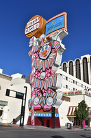
Circus Circus clown sign, Reno, Nevada
Date
Archival Collection
Description
View of the clown sign for the Circus Circus during the day with unlit neon.
500 N Sierra St, Reno, NV 89503
Image
Nancy Wier Papers on Rock Art in Southern Nevada
Identifier
Abstract
The Nancy Wier Papers on Rock Art in Southern Nevada (approximately 1930-2003) contain photographs, notes, research, and publications focused on rock art (rock writing) found in the Southern Nevada Region. Wier founded the Southern Nevada Rock Art Enthusiasts (SNRAE) in 1992, and the photograph albums document trips across Nevada, Southern California, Utah, and Arizona. The photograph albums are grouped by site location, and the description was taken directly from Wier's albums. The majority of the collection documents rock writings in Southern Nevada.
Archival Collection
Meeting minutes for Consolidated Student Senate, University of Nevada, Las Vegas, August 27, 2001
Date
Archival Collection
Description
Text

Exterior view of the Golden Hotel in Las Vegas, Nevada: postcard
Date
Archival Collection
Description
Image

Geologic map of Las Vegas Valley, Nevada, 1982
Date
Description
2320-A. Originally published as plate 1 of Ground-water conditions in Las Vegas Valley, Clark County, Nevada. Part I. Hydrogeologic framework / by Russell W. Plume, published by the U.S. Geological Survey in 1989 as Water-supply paper 2320-A.
Image

Meeting minutes for Consolidated Student Senate, University of Nevada, Las Vegas, September 24, 2001
Date
Archival Collection
Description
Text

Photographic slide of archeological site in Wadsworth, Nevada, circa early 1960s
Date
Archival Collection
Description
Image
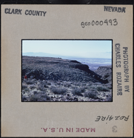
Photographic slide of Clark County, Nevada landscape, circa 1963-1964
Date
Archival Collection
Description
Image

Photographic slide of Pintwater Cave entrance, Nevada, circa 1963-1964
Date
Archival Collection
Description
Image