Search Results

Street map of greater Las Vegas, Nevada, 1965-1966
Date
1965 to 1966
Description
Rev. 1965-1966 ed. 55 x 42 cm., folded to 29 x 12 cm. Panel title: Front Boy's official street map. Relief shown by spot heights. Copyright held by Russell A. Meador. Includes notes, quotations and indexes. Street index on verso. "Detailed guide of North Las Vegas, Las Vegas, Paradise Valley, and vicinity." Original publisher: Meador, Russell A.
Image

Map of California, and territories of Utah, Nevada, Colorado, New Mexico and Arizona, 1864
Date
1864
Description
'Johnson's California, also Utah, Nevada, Colorado, New Mexico, and Arizona, published by A.J. Johnson, New York.' 'Entered according to act of Congress in the year 1864, by A.J. Johnson in the Clerks Office of the District Court of the United States for the southern district of New York.' Atlas page numbers in upper margin: 67-68. Relief shown by hachures. Prime meridian: Greenwich and Washington. Shows natural features, locations of Indian tribes, proposed railroad routes, routes of explorers, trails, county boundaries and populated places. Hand colored. On verso: 'Historical and statistical view of the West India Islands or Columbian Archipelago' (p. 80) and 'Historical and statistical view of Mexico and Central America' (p. 79). Scale [ca. 1:3,484,800]. 1 in. to ca. 55 miles (W 124°--W 102°/N 42°--N 32°).
Text
#68895: A reception to honor English professor Felicia Campbell's 50 years of teaching at UNLV was held in the Tam Alumni Center November 8, 2012 at the University of Nevada, Las Vegas, 2012 November 08
Level of Description
File
Archival Collection
University of Nevada, Las Vegas Creative Services Records (2010s)
To request this item in person:
Collection Number: PH-00388-05
Collection Name: University of Nevada, Las Vegas Creative Services Records (2010s)
Box/Folder: Digital File 00
Collection Name: University of Nevada, Las Vegas Creative Services Records (2010s)
Box/Folder: Digital File 00
Archival Component
UNLV College of Education Alum of the Year and Clark County School District Superintendent Pat Skorkowski poses October 8, 2013 at Hancock Elementary School: digital photographs
Date
2013-10-08
Archival Collection
Description
Photographs from the University of Nevada, Las Vegas Creative Services Records (2010s) (PH-00388-05). Client: UNLV Magazine, Marketing and Public Relations
Image
#70334: UNLV Classified Staff Member of the Year third runner up Erin Azua poses in the Student Wellness Center July 2, 2015 at the University of Nevada, Las Vegas., 2015 July 02
Level of Description
File
Archival Collection
University of Nevada, Las Vegas Creative Services Records (2010s)
To request this item in person:
Collection Number: PH-00388-05
Collection Name: University of Nevada, Las Vegas Creative Services Records (2010s)
Box/Folder: Digital File 00
Collection Name: University of Nevada, Las Vegas Creative Services Records (2010s)
Box/Folder: Digital File 00
Archival Component
Photocopy of the 1992 article "Ninety Years and Counting" from Rafu Shimpo magazine, approximately 1992 to 1999
Level of Description
File
Archival Collection
Sue Fawn Chung Collection on Asians in Nevada
To request this item in person:
Collection Number: MS-00332
Collection Name: Sue Fawn Chung Collection on Asians in Nevada
Box/Folder: Box 02
Collection Name: Sue Fawn Chung Collection on Asians in Nevada
Box/Folder: Box 02
Archival Component
Regional Transportation Commission of Clark County: "Transportation Improvement Program Fiscal Years 1991-1993", 1990 February 08
Level of Description
File
Archival Collection
Bruce Turner Collection on Transportation and Water in Southern Nevada
To request this item in person:
Collection Number: MS-00648
Collection Name: Bruce Turner Collection on Transportation and Water in Southern Nevada
Box/Folder: Box 30
Collection Name: Bruce Turner Collection on Transportation and Water in Southern Nevada
Box/Folder: Box 30
Archival Component
General education, Faculty Institute on Research Based Learning, Faculty Institute First and Second Year Seminars, 2010-2013
Level of Description
File
Archival Collection
University of Nevada Las Vegas Dean of Libraries Records
To request this item in person:
Collection Number: UA-00072
Collection Name: University of Nevada Las Vegas Dean of Libraries Records
Box/Folder: Box 14 (Restrictions apply)
Collection Name: University of Nevada Las Vegas Dean of Libraries Records
Box/Folder: Box 14 (Restrictions apply)
Archival Component
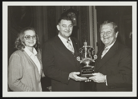
Howard Cannon presents to Malvin Matthews the American Training Association Million Miles Driver of the Year Award: photographic print
Date
1980-02
Archival Collection
Description
From the Howard Cannon Photograph Collection (PH-00192). Stamped on verso: "Photo by: Ankers Capitol Photographers 316 F Street, N.E. Wash., D.C. 20002 Phone 202/543-2484"
Image
T-Shirt Color: Gray; Front: 25 Years Canton TWP 52 Fire Rescue 1976 2001, Fire Emblem W/Fire Equip; Back: Canton Company 52 Fire Rescue Celebrating 25 Years Of Excellence, Two Fire Engines, approximately 2001-2012
Level of Description
File
Archival Collection
New York-New York Hotel and Casino 9-11 Heroes Tribute Collection
To request this item in person:
Collection Number: MS-00459
Collection Name: New York-New York Hotel and Casino 9-11 Heroes Tribute Collection
Box/Folder: Box 453
Collection Name: New York-New York Hotel and Casino 9-11 Heroes Tribute Collection
Box/Folder: Box 453
Archival Component