Search Results
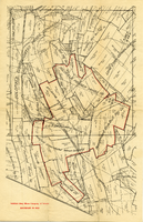
Map of mines owned and operated by Goldfield Deep Mines Company of Nevada, circa 1904-1908
Date
Description
Image
#70931: Kara Toma, Executive Assistant to Gerry Bomotti, third-place recipient in the President's Classified Employee of the Year awards 2016, 2016 July 01
Level of Description
Archival Collection
Collection Name: University of Nevada, Las Vegas Creative Services Records (2010s)
Box/Folder: Digital File 00
Archival Component

Original plat, townsite of Las Vegas, Lincoln Co., Nevada, January 13, 1905
Date
Description
Subtitle: 'Embracing the N. 1/2 of S.W. 1/4 Sec. 27 Township 20S. R.61E. Mt. Diablo Meridian.' 'Book 1, page 17A" handwritten in lower right corner. Signed by Henry Lee, County Recorder, Lincoln County Nevada. 'Filed at request of J.T. Williams, January 13th A.D. 1905.' Backwards handwriting on right side. Map has a Lincoln County seal on the bottom near the center. In the dedication J.T. McWilliams states that he has surveyed and platted the townsite of Las Vegas subject to the right of way of the San Pedro, Los Angeles and Salt Lake Railroad Company. He signed the dedication on Jan. 13, 1905, and it was signed by witnesses Scale [ca. 1:2,520? 1 inch to approx. 210 feet?]. Copy of a blueline print.
Image
The Prince of the House of David; or, three years in the Holy City by Ingraham, Rev. J. H. (edited by). London: Frederick Warne and Co., approximately 1890 to 1899
Level of Description
Archival Collection
Collection Name: Mavis Eggle "Books as They Were Bought" Collection
Box/Folder: No Container 00
Archival Component
River Inn, Reno, NV: Casino Control Corporation, "Prospected Statement of Consolidated Operating Income for Second Year of Operation" report, 1982 October 20
Level of Description
Archival Collection
Collection Name: Gary W. Royer Collection on Gaming
Box/Folder: Box 078 (Restrictions apply)
Archival Component
Emma Schaefle (Schuyler), Mabel Schaefle (Hitte) and William J. Schaefle as children. Emma (left) is about 9-10 years old: photographic print, approximately 1889
Level of Description
Archival Collection
Collection Name: Schuyler Family Photograph Collection
Box/Folder: Digital File 00
Archival Component
Plaque: Neighborhood Services Department, "Frank Reynolds - With Appreciation for Twenty Two Years of Outstanding Service and Dedication to the City of Las Vegas", 2007 May 17
Level of Description
Archival Collection
Collection Name: Frank Reynolds Professional Papers
Box/Folder: Box 19 (Restrictions apply)
Archival Component
Nevada Poetry Society Records
Identifier
Abstract
The Nevada Poetry Society Records are comprised of the Society's records dating from 1961 to 1973. Society organizer and president, Mildred Breedlove is featured prominently in the collection. Materials include Silver Strings: Nevada Poetry Society Anthology, a collection of poems commemorating Nevada's centennial year, individual poems from members, financial records, correspondence, and newsletters.
Archival Collection
T-Shirt Color: Gray; Front: Johnson Memorial Hospital 51 Years Of Caring; Back: United Way 1998, Organization Logo, approximately 2001-2012
Level of Description
Archival Collection
Collection Name: New York-New York Hotel and Casino 9-11 Heroes Tribute Collection
Box/Folder: Box 173
Archival Component
T-Shirt Color: Navy Blue; Front: Newton Steamers 801 "We Are # 1", Dept. Emblem; Back: E-801 # 1 For Over 125 Years, approximately 2001-2012
Level of Description
Archival Collection
Collection Name: New York-New York Hotel and Casino 9-11 Heroes Tribute Collection
Box/Folder: Box 209
Archival Component