Search the Special Collections and Archives Portal
Search Results
Sandy O'Brien, Dance department administrative assistant and Classified Employee of the Year runner-up on September 10, 2013: digital photographs
Date
2013-09-10
Archival Collection
Description
Photographs from the University of Nevada, Las Vegas Creative Services Records (2010s) (PH-00388-05). Client: Diane Russell, University Communications
Image
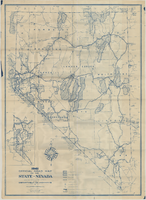
Official road map of the State of Nevada, 1941
Date
1941
Archival Collection
Description
Compiled and published for free distribution by the Department of Highways, Carson City, Nevada. Board of Directors: Governor E.P. Carville, Chairman; Gray Mashburn, Member; Henry Schmidt, Member; Robert A. Allen, State Highway Engineer. Nevada Department of Highways
Image

Kara Toma, Executive Assistant to Gerry Bomotti, third-place recipient in the President's Classified Employee of the Year awards 2016: digital photographs
Date
2016-07-01
Archival Collection
Description
Photographs from the University of Nevada, Las Vegas Creative Services Records (2010s) (PH-00388-05). Client: Diane Russell/News Center
Image
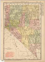
Map showing railroads in Nevada, 1911
Date
1911
Description
Relief shown by hachures. Title below scale: Rand McNally & Co.'s New business atlas map of Nevada. Shows railroads. Includes township and range grid. Includes index to principal cities with population statistics. Includes township and range grid. Index to Nevada counties, lakes, mountains, rivers, towns, etc. on verso. Published by Rand McNally & Co. Scale [ca. 1,710,720]. 1 in. = 27 miles (W 120°--W 114°/N 42°--N 35°). Published as page 321 of Rand-McNally indexed atlas.
Text
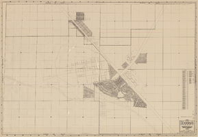
Map, city of Henderson, Nevada, August 1, 1955
Date
1955-08-01
Description
'Compiled by Pioneer Title Insurance & Trust Company.' '8/1/55.' Includes street index.
Image
"Preparing for the 21st Century: 40 Years of Excellence" by the Lawrence Livermore National Laboratory, book, 1992
Level of Description
File
Archival Collection
Nevada Desert Experience Records
To request this item in person:
Collection Number: MS-00524
Collection Name: Nevada Desert Experience Records
Box/Folder: Box 21
Collection Name: Nevada Desert Experience Records
Box/Folder: Box 21
Archival Component
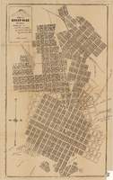
Map of Goldfield, Nevada, April 25, 1907
Date
1907-04-25
Description
'Compiled by James H. Parks, U.S. Deputy Min. Sur., Box 655, Goldfield, Nev. April 25, 1907.' 'Nevada Press Company, Carson City, Nevada.' Scale: [ca. 1:4,800] 1 inch = 400 ft. Plat map. Library's copy has notes handwritten in pencil along right margin with arrows to locations on map: "Ramsey Street ended Columbia St." "MacMaskrs office." "Lived on Euclid ave in adobe house." " Lived in Tent House Sundog Ave."
Image
#62471: 10 Year Portraits - Hampton, Carl; Clawson, Todd; Roybal, Anthony, 1999 November 04
Level of Description
File
Archival Collection
University of Nevada, Las Vegas Creative Services Records (1990s)
To request this item in person:
Collection Number: PH-00388-03
Collection Name: University of Nevada, Las Vegas Creative Services Records (1990s)
Box/Folder: N/A
Collection Name: University of Nevada, Las Vegas Creative Services Records (1990s)
Box/Folder: N/A
Archival Component
Pagination
Refine my results
Content Type
Creator or Contributor
Subject
Archival Collection
Digital Project
Resource Type
Year
Material Type
Place
Language
Records Classification

