Search Results
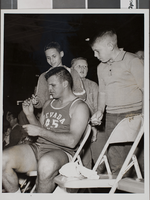
Photograph of basketball players, Nevada Southern University, 1963-1964
Date
1963 to 1964
Archival Collection
Description
Nevada Southern basketball player signs autographs for young fans at Nevada Southern University (NSU).
Image
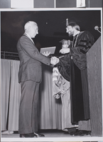
Photograph of commencement for the University of Nevada, Las Vegas, 1977
Date
1977
Archival Collection
Description
The commencement ceremony for the University of Nevada, Las Vegas. Pictured here includes E. Parry Thomas (left) and President Donald Baepler (right).
Image
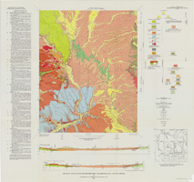
Geologic map of the Buckboard Mesa quadrangle, Nye County, Nevada, 1966
Date
1966
Description
58 x 46 cm., on sheet 87 x 91 cm., folded in envelope 30 x 24 cm. Relief shown by contours and spot heights. "Contour interval 20 feet." "Prepared in cooperation with the U.S. Atomic Energy Commission." "Geology mapped in 1962-63." Includes text, 2 col. cross sections, and 2 index maps. Original publisher: U.S. Geological Survey, Series: Geologic quadrangle map GQ, Scale: 1:24 000.
Image
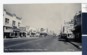
Shops on Fremont Street, Las Vegas, Nevada: photograph
Date
1946 to 1949
Archival Collection
Description
Fremont Street postcard, Las Vegas Nevada. Text at the bottom reads: "New shops along the Main Street-Las Vegas, Nev."
Image
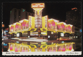
Mapes Money Tree Casino in Reno, Nevada: postcard
Date
1979 (year approximate)
Archival Collection
Description
From the Harvey's Hotel and Casino Postcard Collection (PH-00367) -- Mapes Money Tree Casino in Reno, Nevada at night circa 1979
Image
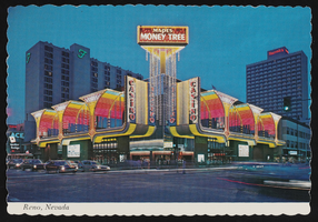
Mapes Money Tree Casino in Reno, Nevada: postcard
Date
1970 (year approximate) to 1989 (year approximate)
Archival Collection
Description
From the Harvey's Hotel and Casino Postcard Collection (PH-00367) -- Mapes Money Tree Casino in Reno, Nevada circa 1970s-1980s
Image
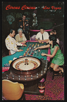
Gambers at Circus Circus in Las Vegas, Nevada: postcard
Date
1940 (year approximate) to 1990 (year approximate)
Archival Collection
Description
From the Harvey's Hotel and Casino Postcard Collection (PH-00367) -- People playing roulette at the Circus Circus Casino in Las Vegas, Nevada.
Image
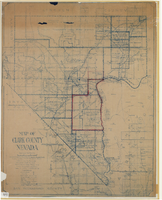
Map of Clark County, Nevada, 1927
Date
1927
Description
'Compiled by J.T. McWilliams from official county records, U.S. Land Dept. surveys, railroad co. field maps and many personal surveys. Made in 1927 by J.T. McWilliams, C.E.' Includes township and road districts, school districts, mining districts, railroads, wagon roads, trails, springs and artesian wells. Scale [ca. 1:316,800. 1 in. to approx. 5 miles] (W 116°--W 114°/N37--N35). Relief shown by hachures. Blueline print. Library's copy 1 has one area outlined by hand in red. Library's copy 2 has school districts outlined in red and green pencil and labeled in pencil by hand.
Image