Search Results
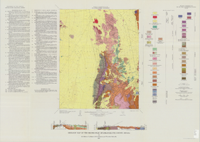
Geologic map of the Belted Peak quadrangle, Nye County, Nevada, 1967
Date
1967
Description
45 x 36 cm., on sheet 64 x 89 cm., fold. in envelope 30 x 24 cm. Relief shown by contours and spot heights. "Contour interval 40 feet." "Prepared in cooperation with the U.S. Atomic Energy Commission." "Geology mapped in 1962-63." Includes text, 2 col. cross sections, and quadrangle location map. Original publisher: U.S. Geological Survey, Series: Geologic quadrangle map GQ, Scale: 1:62 500.
Image
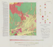
Geologic map of the Thirsty Canyon quadrangle, Nye County, Nevada, 1966
Date
1966
Description
57 x 46 cm., on sheet 83 x 91 cm., folded in envelope 30 x 24 cm. Relief shown by contours and spot heights. "Geology mapped in 1963." Includes 2 colored cross sections, index map, text, and quadrangle location map. "Prepared in cooperation with the U. S. Atomic Commission." Original publisher: Interior, Geological Survey, Series: Geologic quadrangle map GQ, Scale: 1:24 000.
Image
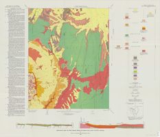
Geologic map of the Trail Ridge quadrangle, Nye County, Nevada, 1968
Date
1968
Description
58 x 46 cm., on sheet 79 x 91 cm., folded in envelope 30 x 24 cm. Relief shown by contours and spot heights. "Prepared in cooperation with the U.S. Atomic Energy Commission." "Base by U.S. Geological Survey, 1962." "Geology mapped in 1963." "Contour interval 20 feet." Includes text, 2 col. cross sections, quadrangle location map, and 1 index map. Original publisher: Interior, Geological Survey, Series: Geologic quadrangle map GQ, Scale: 1:24 000.
Image
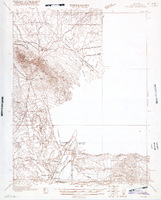
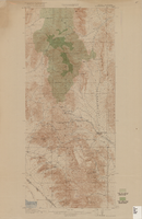
Map of Ely Range Quadrangle, Lincoln County, Nevada, 1921
Date
1921
Description
'Edition of 1921.' 'W. H. Herron, Acting Chief Geographer; Geo. R. Davis, Geographer In Charge; Topography by H. H. Hodgeson, N. E. Ballmer, and W. B. Upton, Jr.; Control by H. H. Hodgeson, Roscoe Reeves, and D. S. Birkett. Surveyed in 1916.' At top of map: ' Topography, State of Nevada.' At upper left corner: ' Department of the Interior, Albert B. Fall, Secretary; U.S. Geological Survey, George Otis Smith, Director.' Southern Nevada Mining Map Collection. 15 minute series (topographic) Nevada.
Image
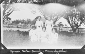
Film transparency of Helen Bunker, Mary Syphus, Florence Bishop, Zella Peterson, and Wanda Ball, presumably in Las Vegas, circa early 1900s
Date
1900 to 1939
Archival Collection
Description
Black and white image of five young women posing for a photo, most likely in Las Vegas, Nevada. The women standing in the top row are Helen Bunker and Mary Syphus, per the handwritten description on the image. The women in the bottom row include Florence Bishop, Zella Peterson, and Wanda Ball. Note: Image is from a family photo album that was loaned to UNLV Libraries Special Collections and returned to the family on July 17, 1984.
Image
Men of the Rochester-Goldfield Mining Company sit in horse-drawn wagons. Rinker is seated in first wagon: photographic print, approximately 1900-1910
Level of Description
Item
Archival Collection
C. A. Earle Rinker Photograph Collection of Goldfield, Nevada
To request this item in person:
Collection Number: PH-00350
Collection Name: C. A. Earle Rinker Photograph Collection of Goldfield, Nevada
Box/Folder: Folder 05
Collection Name: C. A. Earle Rinker Photograph Collection of Goldfield, Nevada
Box/Folder: Folder 05
Archival Component
Topographic map of Goodsprings quadrangle, Nevada and California, 1919
Date
1919
Description
'R.B. Marshall, Chief Geographer; Geo. R. Davis, Geographer in charge; Topography by N.E. Ballmer and Roscoe Reeves; Control by J.E. Blackburn and L.F. Biggs. Surveyed in 1915-1916.' 'Edition of 1919.' Relief shown by hachures and spot heights. Title in lower right margin: Goodsprings. In center of top margin: Topography. Includes compilation diagram. Indicates location and density of cedar trees. Shows small portion of San Bernardino County, California. Published by U.S. Geological Survey. Scale 1:62,500 (W 115°35'00"--W 115°24'00"/N 36°02'30"--N 35°42'30"). 'Contour interval 50 feet. Datum is mean sea level.'
Text
Haller, Mark H. Bootleggers as Businessmen: From City Slums to City Builders, Law, Alcohol, and Order: perspectives on national prohibition, approximately 1900 to 1999
Level of Description
File
Archival Collection
UNLV Libraries Collection of Articles on Gaming and Las Vegas, Nevada Topics
To request this item in person:
Collection Number: MS-00626
Collection Name: UNLV Libraries Collection of Articles on Gaming and Las Vegas, Nevada Topics
Box/Folder: Box 19
Collection Name: UNLV Libraries Collection of Articles on Gaming and Las Vegas, Nevada Topics
Box/Folder: Box 19
Archival Component
Butterfield, Roger. Harold's Club: Country's biggest gambling joint run by Smith family of Reno, Life 19(16), approximately 1900 to 1999
Level of Description
File
Archival Collection
UNLV Libraries Collection of Articles on Gaming and Las Vegas, Nevada Topics
To request this item in person:
Collection Number: MS-00626
Collection Name: UNLV Libraries Collection of Articles on Gaming and Las Vegas, Nevada Topics
Box/Folder: Box 10
Collection Name: UNLV Libraries Collection of Articles on Gaming and Las Vegas, Nevada Topics
Box/Folder: Box 10
Archival Component
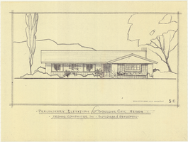
Architectural drawing of residential home in Boulder City, Nevada, preliminary elevation, 1962
Date
1962
Archival Collection
Description
Preliminary drawing of front exterior elevation of a ranch-style residential home in Boulder City, Nevada.
Architecture Period: Mid-Century ModernistImage