Search Results

Nevada Library Notes
Date
Description
Nevada Library Notes, Vol. 1-4 issued by the Nevada State Library. Materials about the news of library activities and articles for publication by Nevada librarians. It also contains minutes of the 18th annual convention.
Text

Map of California, territories of New Mexico, Arizona, Colorado, Nevada and Utah, circa 1863
Date
Description
Image
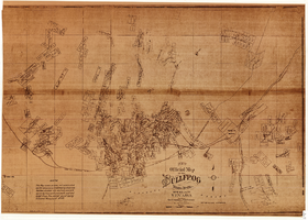
Map of the Bullfrog Mining District, Nye County, Nevada, circa 1905
Date
Description
Image
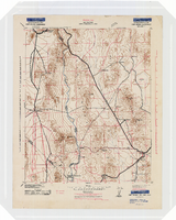
Topographic map of the Camp Mohave quadrangle in California, Nevada and Arizona, 1942
Date
Description
Image

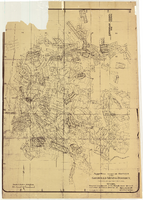
Map of California, Nevada, Utah, Colorado, Arizona & New Mexico, circa 1867
Date
Description
Image
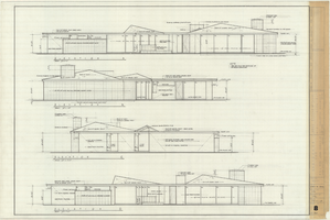
Architectural drawing of the Rugar residence, Las Vegas, Nevada, exterior elevations, December 31, 1962
Date
Archival Collection
Description
Drawings of exterior elevations A, B, C and D for the Rugar residence, Las Vegas, Nevada. "Sheet no. 8 of 20." "James Brooks McDaniel, A.I.A., Architect." "Job no. R62-1." "Drawn by J.M. Checked by J.Mc." "Scale: 1/4" = 1'-0"."
Site Name: Rugar residence
Image

Geologic map and sections of area along Colorado River between Lake Mead and Davis Dam, Arizona and Nevada, 1963
Date
Description
374-E. Originally published as plate 1 in: Reconnaissance geology between Lake Mead and Davis Dam, Arizona-Nevada / by Chester R. Longwell, published by the U.S. Government Printing Office in 1963 in the series Shorter contributions to general geology and as Geological Survey professional paper 374-E.
Image
Map of approved mineral surveys in the Goldfield Mining District, Esmeralda and Nye Counties, Nevada, 1911
Date
Description
Image
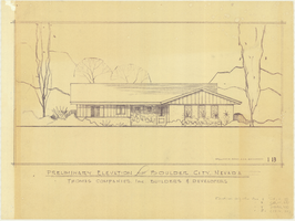
Architectural drawing of residential home in Boulder City, Nevada, preliminary elevation, 1962
Date
Archival Collection
Description
Preliminary drawing of front exterior elevation of ra anch-style residential home in Boulder City, Nevada. Handwritten near lower right: "Elevations only for Plan 1 (1B, 1C, 1D), Plan 2 (2B, 2C, 2D), Plan 4 (4B, 4C, 4D), Plan 5 (5B, 5C, 5D)."
Architecture Period: Mid-Century ModernistImage

Nevada Library Notes
Date
Description
Nevada Library Notes, Vol. 7-8 issued by the Nevada State Library. Materials about the news of library activities and articles for publication by Nevada librarians. It also contains the Nevada Library Association directory from 1969 to 1971.
Text