Search Results
"Fishing trip near Moapa. Early Las Vegans: Ray Mosbach family, Jim Adams family, Leon Rockwell, Sr. family" (written on verso): photographic print, approximately 1915 to 1925
Level of Description
Item
Archival Collection
Leon Rockwell Photograph Collection
To request this item in person:
Collection Number: PH-00008
Collection Name: Leon Rockwell Photograph Collection
Box/Folder: Folder 20
Collection Name: Leon Rockwell Photograph Collection
Box/Folder: Folder 20
Archival Component
Butterfield, Roger. Harold's Club: Country's biggest gambling joint run by Smith family of Reno, Life 19(16), approximately 1900 to 1999
Level of Description
File
Archival Collection
UNLV Libraries Collection of Articles on Gaming and Las Vegas, Nevada Topics
To request this item in person:
Collection Number: MS-00626
Collection Name: UNLV Libraries Collection of Articles on Gaming and Las Vegas, Nevada Topics
Box/Folder: Box 10
Collection Name: UNLV Libraries Collection of Articles on Gaming and Las Vegas, Nevada Topics
Box/Folder: Box 10
Archival Component
Haller, Mark H. Bootleggers as Businessmen: From City Slums to City Builders, Law, Alcohol, and Order: perspectives on national prohibition, approximately 1900 to 1999
Level of Description
File
Archival Collection
UNLV Libraries Collection of Articles on Gaming and Las Vegas, Nevada Topics
To request this item in person:
Collection Number: MS-00626
Collection Name: UNLV Libraries Collection of Articles on Gaming and Las Vegas, Nevada Topics
Box/Folder: Box 19
Collection Name: UNLV Libraries Collection of Articles on Gaming and Las Vegas, Nevada Topics
Box/Folder: Box 19
Archival Component
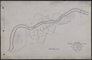
Map of proposed flood control project on the Virgin River in Clark County, Nevada, March, 1934
Date
1934-03
Archival Collection
Description
'Map no. 7 to accompany report on flood control survey. Made by Graham S. Quate. March 1934. Drawn by T.K.' Scale [ca. 1:15, 600. 1 in.=approx. 1,300 feet]. Relief shown by hachures. North oriented to upper right corner. Library's copy has hand-drawn map and notes in pencil on verso.
Image
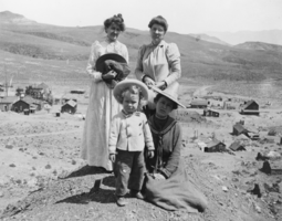
Irving Crowell as a child in Candelaria, Nevada: photographic print
Date
1902
Archival Collection
Description
From the Nye County, Nevada Photograph Collection (PH-00221) -- Series III. Beatty, Nevada -- Subseries III.D. Crowell Family. The women in the photo are unidentified.
Image

Map showing second stage plan of development for Southern Nevada Water Project, March 1981
Date
1981-03
Description
'United States Department of the Interior, Bureau of Reclamation.' 'June 1976. Revised March 1981.' 'Map No. 952-300-203.' 'Exhibit I.' Includes inset location map for project area. Scale [ca. 1:126,720. 1 in. to approx. 2 miles] . United States Department of the Interior, Bureau of Reclamation
Image
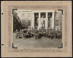
Southern Nevada Photo Album, image 007
Description
University of Nevada R.O.T.C. Band, ca 1924-1925
"Main Street, Manhattan" an early automobile drives down Main Street; Holt & Williams Horseshoe Club, C.A. Cassin groceries, jeweler, and drug store are visibile in background, Manhattan, Nevada: glass plate negative, approximately 1900 to 1909
Level of Description
Item
Archival Collection
E. W. Smith Glass Plate Negatives
To request this item in person:
Collection Number: PH-00460
Collection Name: E. W. Smith Glass Plate Negatives
Box/Folder: Box 01
Collection Name: E. W. Smith Glass Plate Negatives
Box/Folder: Box 01
Archival Component

Map of Las Vegas and vicinity, Clark County, Nevada, November 1952
Date
1952-11
Description
'Copyright 1950. 3rd issue, November 1952.'
Image

Surficial geologic map of the Specter Range NW quadrangle, Nye County, Nevada, 1989
Date
1989
Description
58 x 47 cm., on sheet 74 x 81 cm., folded in envelope 30 x 24 cm. Relief shown by contours and spot heights. "Geology mapped in 1984-85." Includes text, bibliography, and location maps. "Prepared in cooperation with the U. S. Deparment of Energy." "Base from U. S. Geological Survey, 1961. Photorevised 1983. 10,0000-foot grid ticks based on Nevada coordinate system, central zone. 1000-meter Universal Transverse Mercator grid ticks, zone 11, shown in blue." Original publisher: U. S. Geological Survey, Series: Miscellaneous investigations series map I, Scale: 1:24 000.
Image