Search Results
A team of 18 burros pull a wagon loaded with mining machinery across a field: glass plate negative, approximately 1900 to 1909
Level of Description
Item
Archival Collection
E. W. Smith Glass Plate Negatives
To request this item in person:
Collection Number: PH-00460
Collection Name: E. W. Smith Glass Plate Negatives
Box/Folder: Box 02
Collection Name: E. W. Smith Glass Plate Negatives
Box/Folder: Box 02
Archival Component
Tonopah and Goldfield: materials include an interview, notes, and newspaper clippings about the towns' histories, 1900, 1931-1937, 1947, undated
Level of Description
File
Archival Collection
Byrd Wall Sawyer Collection
To request this item in person:
Collection Number: MS-00316
Collection Name: Byrd Wall Sawyer Collection
Box/Folder: Box 04 (Restrictions apply)
Collection Name: Byrd Wall Sawyer Collection
Box/Folder: Box 04 (Restrictions apply)
Archival Component
Helen Bunker, Gladys Boggs, Zatta McDonald, Olive Lake, Norma Brockman, Maria holding a pennant for Goldfield, 1900-1909
Level of Description
File
Archival Collection
Lake-Eglington Family Photograph Collection
To request this item in person:
Collection Number: PH-00010
Collection Name: Lake-Eglington Family Photograph Collection
Box/Folder: Box SH-015
Collection Name: Lake-Eglington Family Photograph Collection
Box/Folder: Box SH-015
Archival Component
Union Pacific Railroad supporting infrastructure and facilities: contains architectural and structural drawings of turntables and store houses in Los Angeles, California, 1919 June 17-1925 March 20
Level of Description
File
Archival Collection
Union Pacific Railroad Collection
To request this item in person:
Collection Number: MS-00397
Collection Name: Union Pacific Railroad Collection
Box/Folder: Flat File 187
Collection Name: Union Pacific Railroad Collection
Box/Folder: Flat File 187
Archival Component
Windsor's welcome home to Her Majesty's First Life Guards, banquet menu, at the White Hart Hotel, 1900 November 30
Level of Description
Item
Archival Collection
Bohn-Bettoni Menu Collection
To request this item in person:
Collection Number: MS-00793
Collection Name: Bohn-Bettoni Menu Collection
Box/Folder: Box 02
Collection Name: Bohn-Bettoni Menu Collection
Box/Folder: Box 02
Archival Component
"1st airplane came to Las Vegas, O.J. Priest" (written on verso): photographic print and negative, approximately 1900 to 1910
Level of Description
Item
Archival Collection
Leon Rockwell Photograph Collection
To request this item in person:
Collection Number: PH-00008
Collection Name: Leon Rockwell Photograph Collection
Box/Folder: Folder 03, Box SH-015
Collection Name: Leon Rockwell Photograph Collection
Box/Folder: Folder 03, Box SH-015
Archival Component
The Italian Benevolent Society and the Home for Aged Poor Fund, ball and supper, menu, The Monico, International Hall, 1900 March 07
Level of Description
Item
Archival Collection
Bohn-Bettoni Menu Collection
To request this item in person:
Collection Number: MS-00793
Collection Name: Bohn-Bettoni Menu Collection
Box/Folder: Box 06
Collection Name: Bohn-Bettoni Menu Collection
Box/Folder: Box 06
Archival Component
May Wheeler Bradford’s collection of Chinese artifacts, pre-Boxer rebellion, 1899-1900: photographic print, 1977 July
Level of Description
Item
Archival Collection
Nan Doughty Photograph Collection
To request this item in person:
Collection Number: PH-00240
Collection Name: Nan Doughty Photograph Collection
Box/Folder: Folder 18
Collection Name: Nan Doughty Photograph Collection
Box/Folder: Folder 18
Archival Component
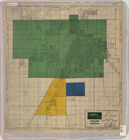
Map of Las Vegas and vicinity, Clark County, Nevada, April 15, 1951
Date
1951-04-15
Description
'2nd issue. 4/15/51.' 'Jack Asher, Reg. C.E. & Land Surveyor, Nev. #305.' Cadastral map..
Image
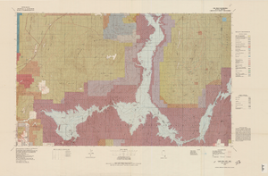
Topographic map of Lake Mead quadrangle, Nevada and Arizona, 1979
Date
1979
Description
'Edited and published by the Bureau of Land Management. Base map prepared by the U.S. Geological Survey.' 'Surface management status by BLM, 1981.Minerals management status by BLM, 1981.' Relief shown by contours and spot heights. Contour interval 50 meters. Compiled from USGS maps dated 1952-1970. Revised from aerial photographs taken 1972-73. Map edited 1979. Includes location map and index to 1:24,000 and 1:62,500-scale maps. Shows minerals owned by the federal government. 'N3600--W11400/30x60.' 'SE/4 Las Vegas (NJ 11-12) 1:250,000-scale map.' Scale 1:100,000
universal transverse Mercator proj. (W 115°00'--W 114°00'/N 36°30'--N 36°00'). Series: Surface-minerals management status. United States. Bureau of Land Management. Surface-minerals management status. Filing title: Lake Mead, Nev.--Ariz., 1979. Shows township and range lines. Published by United States, Dept. of the Interior, Bureau of Land Management
Denver, Colo. : For sale by U.S. Geological Survey,
Image