Search Results

Leadership Development Academy Fellows in the studio on February 26, 2014 at the University of Nevada, Las Vegas: digital photographs
Date
2014-02-26
Archival Collection
Description
Photographs from the University of Nevada, Las Vegas Creative Services Records (2010s) (PH-00388-05).
Image

Leadership Development Academy Fellows in the studio on February 25, 2014 at the University of Nevada, Las Vegas: digital photographs
Date
2014-02-25
Archival Collection
Description
Photographs from the University of Nevada, Las Vegas Creative Services Records (2010s) (PH-00388-05).
Image
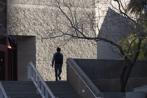
Images from UNLV campus taken February 25, 2014 at the University of Nevada, Las Vegas: digital photographs
Date
2014-02-25
Archival Collection
Description
Photographs from the University of Nevada, Las Vegas Creative Services Records (2010s) (PH-00388-05).
Image
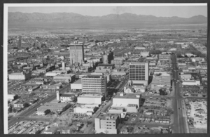
Photograph of downtown Las Vegas, Nevada, circa 1966
Date
1965 to 1967
Archival Collection
Description
An aerial view of downtown Las Vegas, Nevada, looking north. The northwest end of Fremont Street is at the center left side of the photograph. Fourth Street is seen near the right side of the photo. The Mint Hotel, Binion's Horseshoe Club, and the Golden Nugget on Fremont Street and the Clark County Courthouse on Second Street can be seen.
Image

Northwest view of the Brownstone Canyon, Nevada: photographic print
Date
1987 (year approximate)
Archival Collection
Description
From the Eileen Margaret Green Photograph Collection (PH-00229) -- Handwritten on envelope, "Brownstone Canyon, View Northwest. (from her MA thesis. A Cultural Ecological Approach to the Rock Art of Southern Nevada, GN 799 P4 G73x 1987a)". Handwritten on the back of the photograph, "Figure 1. Brownstone Canyon, view northwest."
Image

Northwest view of the Sifted Site, Nevada: photographic print
Date
1987 (year approximate)
Archival Collection
Description
From the Eileen Margaret Green Photograph Collection (PH-00229) -- Handwritten on envelope,"Sifted Site, view northwest. (from her MA thesis. A Cultural Ecological Approach to the Rock Art of Southern Nevada, GN 799 P4 G73x 1987a)". Handwritten on the back of the photograph,"Figure 3. Sifted Site, view northwest."
Image

Photograph of Neil D. Humphrey, University of Nevada, Las Vegas, 1970s
Date
1970 to 1979
Description
A portrait of Neil D. Humphrey, System Chancellor, at the University of Nevada, Las Vegas (UNLV).
Image
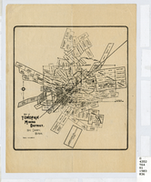
Map of Tonopah Mining District, Nye County, Nevada, circa 1903
Date
1899 to 1907
Description
Map showing mining claims in Tonopah Mining District, including areas owned by Tonopah Amalgamated Mining Co.; David Keith's Company of Salt Lake, Utah; Mispah Extension Company; Tonopah Mining Company of Nevada; Gold Hill Mining Co. Relief shown by hachures. Scale [ca. 1:7,200]. 1 in. equals 600 feet. Library's copy has some mines cross-hatched in pencil.
Image
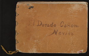
Bound album of El Dorado Cañon in Nevada: photographic print
Date
1920 (year approximate)
Archival Collection
Description
Bound collection of twelve photographs of Eldorado Canyon ("El Dorado Cañon") in Nevada.
Image
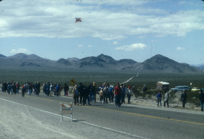
Slide of protesters marching along a highway near the Nevada Test Site, 1984
Date
1984
Archival Collection
Description
Color image of protesters involved with the Lenten Desert Experience (also called the Nevada Desert Experience), a group demonstrating against nuclear testing.
Image