Search the Special Collections and Archives Portal
Search Results
Las Vegas and Henderson, Nevada buildings
Level of Description
File
Archival Collection
Robert Woodruff Photograph Collection
To request this item in person:
Collection Number: PH-00340
Collection Name: Robert Woodruff Photograph Collection
Box/Folder: N/A
Collection Name: Robert Woodruff Photograph Collection
Box/Folder: N/A
Archival Component
Various Las Vegas, Nevada locations
Level of Description
File
Archival Collection
Robert Woodruff Photograph Collection
To request this item in person:
Collection Number: PH-00340
Collection Name: Robert Woodruff Photograph Collection
Box/Folder: N/A
Collection Name: Robert Woodruff Photograph Collection
Box/Folder: N/A
Archival Component
Nevada: statewide management and public lands
Level of Description
File
Archival Collection
Thomas Hickey Political Papers
To request this item in person:
Collection Number: MS-00260
Collection Name: Thomas Hickey Political Papers
Box/Folder: N/A
Collection Name: Thomas Hickey Political Papers
Box/Folder: N/A
Archival Component
Land Valuations and Leases in California and Nevada
Level of Description
File
Archival Collection
Union Pacific Railroad Collection
To request this item in person:
Collection Number: MS-00397
Collection Name: Union Pacific Railroad Collection
Box/Folder: N/A
Collection Name: Union Pacific Railroad Collection
Box/Folder: N/A
Archival Component
Southern Nevada Water Project, 1955-1983
Level of Description
Series
Scope and Contents
The Southern Nevada Water Project Series consists of materials related to water projects in Southern Nevada from 1955 to 1983. It consists primarily of appraisals for land to be acquired for flood control projects in Las Vegas and Henderson, Nevada.
Archival Collection
Elmo C. Bruner Architectural and Real Estate Appraisal Records
To request this item in person:
Collection Number: MS-00177
Collection Name: Elmo C. Bruner Architectural and Real Estate Appraisal Records
Box/Folder: N/A
Collection Name: Elmo C. Bruner Architectural and Real Estate Appraisal Records
Box/Folder: N/A
Archival Component

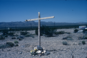
Slide of a wooden cross near the Nevada Test Site, May 8, 1984
Date
1984-05-08
Archival Collection
Description
Colors image of a wooden cross placed in the ground by the Lenten Desert Experience (also called the Nevada Desert Experience), a group protesting nuclear testing.
Image
Nevada State Supreme Court Decision
Level of Description
File
Archival Collection
Rodney Sumpter Papers on Doe v. Bryan
To request this item in person:
Collection Number: MS-00411
Collection Name: Rodney Sumpter Papers on Doe v. Bryan
Box/Folder: N/A
Collection Name: Rodney Sumpter Papers on Doe v. Bryan
Box/Folder: N/A
Archival Component
Henderson Nevada Lake Mead Stake
Level of Description
File
Archival Collection
Alton Dean Jensen Architectural Records
To request this item in person:
Collection Number: MS-00843
Collection Name: Alton Dean Jensen Architectural Records
Box/Folder: N/A
Collection Name: Alton Dean Jensen Architectural Records
Box/Folder: N/A
Archival Component
Geiger Grade near Reno, Nevada
Level of Description
File
Archival Collection
Mary Griffith Toleno Photograph Collection
To request this item in person:
Collection Number: PH-00021
Collection Name: Mary Griffith Toleno Photograph Collection
Box/Folder: N/A
Collection Name: Mary Griffith Toleno Photograph Collection
Box/Folder: N/A
Archival Component
Brasilia Village, Las Vegas, Nevada
Level of Description
File
Archival Collection
Harry Hayden Whiteley Architectural Records
To request this item in person:
Collection Number: MS-00134
Collection Name: Harry Hayden Whiteley Architectural Records
Box/Folder: N/A
Collection Name: Harry Hayden Whiteley Architectural Records
Box/Folder: N/A
Archival Component
Pagination
Refine my results
Content Type
Creator or Contributor
Subject
Archival Collection
Digital Project
Resource Type
Year
Material Type
Place
Language
Records Classification
