Search Results
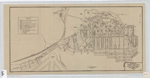
Cadastral map of Boulder City, Nevada, 1940
Date
Description
A. M. S. Jan. 1940 in the lower left-hand corner. 1 map ; 61 x 30 cm. Cadastral map. "No. 40-1" in the lower right-hand corner. Shows block and lot numbers, buildings, water supply and sewage system, leased areas.
Image
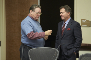
Nevada Board of Regents select Dr. Len Jessup as the next President of UNLV November 18, 2014 at the University of Nevada, Las Vegas: digital photographs
Date
Archival Collection
Description
Photographs from the University of Nevada, Las Vegas Creative Services Records (2010s) (PH-00388-05).
Image
Tonopah, Nevada, 1902-1989
Level of Description
Scope and Contents
Materials contain photographs of the ranches and mining operations around Tonopah, Nevada from 1902 to 1989. Materials include photographs of residents of the town of Tonopah, the tungsten mine in Smoky Valley, Railroad Valley and Iron Canyon, mills, Stewart Indian School in Carson City, Stone Valley, Terrell Mine, and bars and clubs in Tonopah.
Archival Collection
Collection Name: Nye County, Nevada Photograph Collection
Box/Folder: N/A
Archival Component
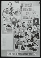
Pioneer Women of Nevada poster displayed at the Nevada Women's Conference: photographic print
Date
Archival Collection
Description
Image

Lenten Desert Experience, Nevada Test Site sign, Nevada.: photographic slide
Date
Archival Collection
Description
From the Sister Klaryta Antoszewska Photograph Collection (PH-00352).
Image
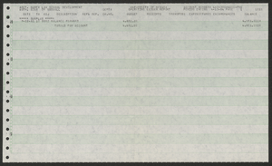
University of Nevada, Las Vegas law school development account: operating ledger reports
Date
Archival Collection
Description
Folder contains operating ledger reports for law school development account. From the University of Nevada, Las Vegas William S. Boyd School of Law Records (UA-00048).
Text
Slide: Nevada Southern University sign, University of Nevada, Las Vegas, 1969
Level of Description
Archival Collection
Collection Name: University of Nevada, Las Vegas Photograph Collection
Box/Folder: Binder PB-002
Archival Component
Nevada Dance Theatre performance, Las Vegas, Nevada, approximately 1970-1979
Level of Description
Archival Collection
Collection Name: University of Nevada, Las Vegas Photograph Collection
Box/Folder: Folder 21
Archival Component
Nevada Southern University Commencement, Las Vegas, Nevada, 1965 June 14
Level of Description
Archival Collection
Collection Name: University of Nevada, Las Vegas Photograph Collection
Box/Folder: Folder 11
Archival Component
Nevada Southern University Commencement, Las Vegas, Nevada, 1965 June 14
Level of Description
Archival Collection
Collection Name: University of Nevada, Las Vegas Photograph Collection
Box/Folder: Folder 12
Archival Component