Search Results
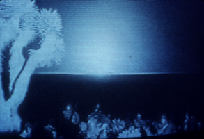
Above-ground nuclear tests at the Nevada Test Site, Nevada: photographic slide
Date
1977 (year approximate) to 1991 (year approximate)
Archival Collection
Description
From the Sister Klaryta Antoszewska Photograph Collection (PH-00352). Slides #0735 through 0749.
Image
Nevada Beverage Company: Las Vegas, Nevada
Level of Description
File
Archival Collection
Homer Rissman Architectural Records
To request this item in person:
Collection Number: MS-00452
Collection Name: Homer Rissman Architectural Records
Box/Folder: Box 29
Collection Name: Homer Rissman Architectural Records
Box/Folder: Box 29
Archival Component
Jean Nevada Fayle, Goodsprings, Nevada, undated
Level of Description
File
Archival Collection
Fayle Family Photographs
To request this item in person:
Collection Number: PH-00113
Collection Name: Fayle Family Photographs
Box/Folder: Folder 07
Collection Name: Fayle Family Photographs
Box/Folder: Folder 07
Archival Component

Center Street in Reno, Nevada: postcard
Date
1940 (year approximate) to 1990 (year approximate)
Archival Collection
Description
From the Harvey's Hotel and Casino Postcard Collection (PH-00367) -- View of Center Street in Reno, Nevada. Shown are the Palace Club and Golden Bank Club.
Image

The Boulder Club in Reno, Nevada: postcard
Date
1940 (year approximate) to 1990 (year approximate)
Archival Collection
Description
From the Harvey's Hotel and Casino Postcard Collection (PH-00367) -- A night time view of the Boulder Club sign and marquee lit up in Reno, Nevada.
Image
Nevada Legislature: Nevada Association of Counties, 1979
Level of Description
File
Archival Collection
John Vergiels Political Papers
To request this item in person:
Collection Number: MS-00283
Collection Name: John Vergiels Political Papers
Box/Folder: Box 033 (Restrictions apply)
Collection Name: John Vergiels Political Papers
Box/Folder: Box 033 (Restrictions apply)
Archival Component
Nevada Legislature: Nevada Association of Realtors, 1980
Level of Description
File
Archival Collection
John Vergiels Political Papers
To request this item in person:
Collection Number: MS-00283
Collection Name: John Vergiels Political Papers
Box/Folder: Box 033 (Restrictions apply)
Collection Name: John Vergiels Political Papers
Box/Folder: Box 033 (Restrictions apply)
Archival Component
Nevada Legislature: Nevada Cattlemen’s Association, 1979
Level of Description
File
Archival Collection
John Vergiels Political Papers
To request this item in person:
Collection Number: MS-00283
Collection Name: John Vergiels Political Papers
Box/Folder: Box 033 (Restrictions apply)
Collection Name: John Vergiels Political Papers
Box/Folder: Box 033 (Restrictions apply)
Archival Component
Nevada Legislature: City of Henderson, Nevada, 1980
Level of Description
File
Archival Collection
John Vergiels Political Papers
To request this item in person:
Collection Number: MS-00283
Collection Name: John Vergiels Political Papers
Box/Folder: Box 032 (Restrictions apply)
Collection Name: John Vergiels Political Papers
Box/Folder: Box 032 (Restrictions apply)
Archival Component
Nevada Legislature: Libertarian Party of Nevada, 1979
Level of Description
File
Archival Collection
John Vergiels Political Papers
To request this item in person:
Collection Number: MS-00283
Collection Name: John Vergiels Political Papers
Box/Folder: Box 033 (Restrictions apply)
Collection Name: John Vergiels Political Papers
Box/Folder: Box 033 (Restrictions apply)
Archival Component