Search Results
#69071: The annual 25 Year Club breakfast held inside Tam Alumni Center on April 11, 2013, 2013 April 11
Level of Description
File
Archival Collection
University of Nevada, Las Vegas Creative Services Records (2010s)
To request this item in person:
Collection Number: PH-00388-05
Collection Name: University of Nevada, Las Vegas Creative Services Records (2010s)
Box/Folder: Digital File 00
Collection Name: University of Nevada, Las Vegas Creative Services Records (2010s)
Box/Folder: Digital File 00
Archival Component
#69809: Liz Smith, Geoscience Administrative Assistant III and President's Classified Employee of the Year on July 22, 2014, 2014 July 22
Level of Description
File
Archival Collection
University of Nevada, Las Vegas Creative Services Records (2010s)
To request this item in person:
Collection Number: PH-00388-05
Collection Name: University of Nevada, Las Vegas Creative Services Records (2010s)
Box/Folder: Digital File 00
Collection Name: University of Nevada, Las Vegas Creative Services Records (2010s)
Box/Folder: Digital File 00
Archival Component
#70757: Las Vegas City Councilman Ricki Barlow, Urban Affairs Alumnus of the Year on March 17, 2016., 2016 March 17
Level of Description
File
Archival Collection
University of Nevada, Las Vegas Creative Services Records (2010s)
To request this item in person:
Collection Number: PH-00388-05
Collection Name: University of Nevada, Las Vegas Creative Services Records (2010s)
Box/Folder: Digital File 00
Collection Name: University of Nevada, Las Vegas Creative Services Records (2010s)
Box/Folder: Digital File 00
Archival Component

Map of California, and territories of Utah, Nevada, Colorado, New Mexico and Arizona, 1864
Date
1864
Description
'Johnson's California, also Utah, Nevada, Colorado, New Mexico, and Arizona, published by A.J. Johnson, New York.' 'Entered according to act of Congress in the year 1864, by A.J. Johnson in the Clerks Office of the District Court of the United States for the southern district of New York.' Atlas page numbers in upper margin: 67-68. Relief shown by hachures. Prime meridian: Greenwich and Washington. Shows natural features, locations of Indian tribes, proposed railroad routes, routes of explorers, trails, county boundaries and populated places. Hand colored. On verso: 'Historical and statistical view of the West India Islands or Columbian Archipelago' (p. 80) and 'Historical and statistical view of Mexico and Central America' (p. 79). Scale [ca. 1:3,484,800]. 1 in. to ca. 55 miles (W 124°--W 102°/N 42°--N 32°).
Text
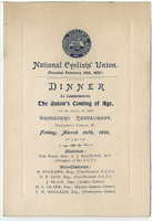
National Cyclist Union dinner to commemorate the Union's coming of age, menu, Friday, March 24, 1899, at Trocadero Restaurant
Date
1899-03-24
Archival Collection
Description
Note: National Cyclists' Union was founded February 16, 1878 Menu insert: Music Programs Restaurant: Trocadero Restaurant Location: Piccadilly Circus, W., London, England
Text
72 Years in Las Vegas: Las Vegas Centennial grant files and publication information, 2013 to 2014
Level of Description
File
Archival Collection
Women of Diversity Productions, Inc. Records
To request this item in person:
Collection Number: MS-01161
Collection Name: Women of Diversity Productions, Inc. Records
Box/Folder: Box 02
Collection Name: Women of Diversity Productions, Inc. Records
Box/Folder: Box 02
Archival Component
Spring Valley View newspaper cover story on Chinese New Year celebrations, 2008 February 05
Level of Description
File
Archival Collection
Lohan School of Shaolin Records
To request this item in person:
Collection Number: MS-01206
Collection Name: Lohan School of Shaolin Records
Box/Folder: Box 01
Collection Name: Lohan School of Shaolin Records
Box/Folder: Box 01
Archival Component
Awards and honors: Greater Las Vegas Chamber of Commerce EPY (Entertainment Personality of the Year) award, press clippings and programs, 1976 January
Level of Description
File
Archival Collection
Donn Arden Papers
To request this item in person:
Collection Number: MS-00425
Collection Name: Donn Arden Papers
Box/Folder: Box 1
Collection Name: Donn Arden Papers
Box/Folder: Box 1
Archival Component
City of Las Vegas Five Year Capital Improvement Plan, budget hearings, Downtown Las Vegas 2045 Vision, 2015 to 2020
Level of Description
File
Archival Collection
Bob Coffin Political Papers
To request this item in person:
Collection Number: MS-01054
Collection Name: Bob Coffin Political Papers
Box/Folder: Box 106
Collection Name: Bob Coffin Political Papers
Box/Folder: Box 106
Archival Component
City of Las Vegas Five Year Capital Improvement Plan, Las Vegas Metropolitan Police Department final budget, 2016 to 2020
Level of Description
File
Archival Collection
Bob Coffin Political Papers
To request this item in person:
Collection Number: MS-01054
Collection Name: Bob Coffin Political Papers
Box/Folder: Box 104
Collection Name: Bob Coffin Political Papers
Box/Folder: Box 104
Archival Component