Search Results
T-Shirt Color: Navy Blue; Front: Newton Steamers 801 "We Are # 1", Dept. Emblem; Back: E-801 # 1 For Over 125 Years, approximately 2001-2012
Level of Description
Archival Collection
Collection Name: New York-New York Hotel and Casino 9-11 Heroes Tribute Collection
Box/Folder: Box 209
Archival Component
T-Shirt Color: Gray; Front: Grande Prairie Firefighters Assoc., IAFF Local 2770, Twenty Years, Canadian Maple Leaf, approximately 2001-2012
Level of Description
Archival Collection
Collection Name: New York-New York Hotel and Casino 9-11 Heroes Tribute Collection
Box/Folder: Box 342
Archival Component

Original plat, townsite of Las Vegas, Lincoln Co., Nevada, January 13, 1905
Date
Description
Subtitle: 'Embracing the N. 1/2 of S.W. 1/4 Sec. 27 Township 20S. R.61E. Mt. Diablo Meridian.' 'Book 1, page 17A" handwritten in lower right corner. Signed by Henry Lee, County Recorder, Lincoln County Nevada. 'Filed at request of J.T. Williams, January 13th A.D. 1905.' Backwards handwriting on right side. Map has a Lincoln County seal on the bottom near the center. In the dedication J.T. McWilliams states that he has surveyed and platted the townsite of Las Vegas subject to the right of way of the San Pedro, Los Angeles and Salt Lake Railroad Company. He signed the dedication on Jan. 13, 1905, and it was signed by witnesses Scale [ca. 1:2,520? 1 inch to approx. 210 feet?]. Copy of a blueline print.
Image

Topographic map of Cane Spring, Nevada quadrangle, 1961
Date
Description
For sale by the U.S. Geological Survey
Image

Map of Las Vegas and vicinity, Nevada, circa 1957-1961
Date
Description
70 x 68 cm. on sheet 106 x 71 cm. Includes indexes. Includes Nellis Air Force Base, Henderson, and inset maps of Boulder City, Nevada, and Las Vegas's geographical location in the Southwest. "H-654-32" on the lower right-hand corner. Page 2 contains a photograph of the Fremont Street in Downtown Las Vegas, featuring the Golden Nugget Gambling Hall and the Horseshoe Casino. Page 3 outlines local and regional attractions, as well as population information. Original publisher: R. L. Polk.
Image

Map of Argentite Red Mountain Mining District, Esmeralda County, Nevada, circa 1908-1913
Date
Description
Image
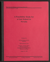
A Feasibility Study for a Law School in Nevada (bound)
Date
Archival Collection
Description
A bound version of "A Feasibility Study for a Law School in Nevada" prepared by R. Keith Schwer, Ph. D., Director, with assistance from George L. Fussell, M.B.A., Research Associate, and Mohammed H. Risheg, M.B.A., Research Associate, The Center for Business and Economic Research, University of Nevada, Las Vegas. From the University of Nevada, Las Vegas William S. Boyd School of Law Records (UA-00048).
Text
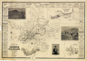
Map of Tonopah Mining District, Nye County, Nevada, 1902
Date
Description
Text