Search Results

Topographic map of Cane Spring, Nevada quadrangle, 1961
Date
1961
Description
'Mapped, edited and published by the Geological Survey in cooperation with the Atomic Enegry Commission. Control by USGS, USC&GS, USCE, and Atomic Energy Commission. Topography from aerial photographs by photogrammetric methods. Aerial photographs taken 1959. Field check 1961.' Scale 1:24,000 polyconic projection (W 116°07'30"--W 116°00'00"/N 36°52'30"--N 36°45'00"). Series: 7.5 minute series (topographic). Relief shown by contours and spot heights. Contour interval 20 feet. Includes quadrangle location map. Interior--Geological Survey
For sale by the U.S. Geological Survey
For sale by the U.S. Geological Survey
Image

The Italian Benevolent Society and the Home for Aged Poor Fund, ball and supper, menu, Wednesday, March 7, 1900, The Monico, International Hall
Date
1900-03-07
Archival Collection
Description
Note: Ball was under the high patronage of His Excellency Baron de Renzis di Montanaro, Ambassador of H. M. the King of Italy; Supper served in the Renaissance, Egyptian and Louis XV Saloons Menu insert: Music Programs; Dancing engagement cards Restaurant: The Monico Location: London, England
Text

Geologic map of the Jangle Ridge quadrangle, Nye and Lincoln Counties, Nevada, 1965
Date
1965
Description
58 x 46 cm., on sheet 84 x 87 cm., folded in envelope 30 x 24 cm. Relief shown by contours and spot heights. "Contour interval 20 feet." "Prepared in cooperation with the U.S. Atomic Energy Commission." "Geology mapped in 1961. Limit of pluvial Groom Lake and faults from photographs mapped by R. B. Colton, 1962." Includes text, bibliography, location map, and 5 col. cross sections. Original publisher: Interior, U.S. Geological Survey, Series: Geologic quadrangle map GQ, Scale: 1:24 000.
Image

Map of California, Utah, Nevada, Colorado, New Mexico and Arizona, 1864
Date
1864
Description
'Johnson's California, also Utah, Nevada, Colorado, New Mexico, and Arizona, published by A.J. Johnson, New York.' 'Entered according to Act of Congress in the Year 1864, by A.J. Johnson in the Clerks Office of the District Court of the United States for the Southern District of New York.' Atlas page numbers in upper margin: 66-67. Relief shown by hachures. Prime meridians: Greenwich and Washington, D.C. Shows proposed railroads, locations of Indian tribes, natural features, counties, mines, mail routes, trails and routes of exploring expeditions. On verso: History and statistics of Mexico and Central America and statistics of national finances and the Post Office of the United States, 1860. Scale [ca. 1:3,484,800. 1 in. to ca. 55 miles] (W 123°--W 103°/N 42°--N 32°)
Text
Main Street, Goldfield, Nevada, postcard
Description
Postcard of Main Street, Goldfield, Nevada.
The History of the Convict Hulk "Success" and "Success" Prisoners by Harvie, Joseph C. . Leeds: Petty & Sons, Ltd., 1900
Level of Description
Item
Archival Collection
Mavis Eggle "Books as They Were Bought" Collection
To request this item in person:
Collection Number: MS-01144
Collection Name: Mavis Eggle "Books as They Were Bought" Collection
Box/Folder: No Container 00
Collection Name: Mavis Eggle "Books as They Were Bought" Collection
Box/Folder: No Container 00
Archival Component
Electric Service Supplies Co.: Philadelphia-Chicago-New York Franklin Sales Co. catalog no. 5, 1900 to 1909
Level of Description
Item
Archival Collection
Raymond Brooks Papers on Mining
To request this item in person:
Collection Number: MS-01153
Collection Name: Raymond Brooks Papers on Mining
Box/Folder: Box 05
Collection Name: Raymond Brooks Papers on Mining
Box/Folder: Box 05
Archival Component
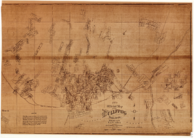
Map of the Bullfrog Mining District, Nye County, Nevada, circa 1905
Date
1901 to 1909
Description
'Compiled by Geo. E. Sherer and W.B. Milliken, miners and surveyors, Bull Frog, Nye Co., Nevada.' 'Photo. Lith. Britton & Rey, S.F.' Scale [ca. 1:16,800. 1 inch to approximately 1,400 feet]. Blueline print.
Image
Betty Trevor by de Horne Vaizey, Mrs. George. London: The Religious Tract Society, approximately 1900 to 1909
Level of Description
Item
Archival Collection
Mavis Eggle "Books as They Were Bought" Collection
To request this item in person:
Collection Number: MS-01144
Collection Name: Mavis Eggle "Books as They Were Bought" Collection
Box/Folder: No Container 00
Collection Name: Mavis Eggle "Books as They Were Bought" Collection
Box/Folder: No Container 00
Archival Component
Rubaiyat of Omar Khayyam: the astronomer poet of Persia by Edward Fitz Gerald. London: T. N. Foulis, approximately 1900 to 1909
Level of Description
Item
Archival Collection
Mavis Eggle "Books as They Were Bought" Collection
To request this item in person:
Collection Number: MS-01144
Collection Name: Mavis Eggle "Books as They Were Bought" Collection
Box/Folder: Box 30
Collection Name: Mavis Eggle "Books as They Were Bought" Collection
Box/Folder: Box 30
Archival Component