Search Results

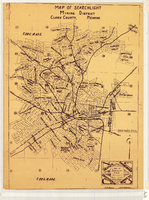
Map of Tonopah Mining District, Nevada, circa 1905
Date
1900 to 1910
Description
Scale [ca.1:12,804. 1 in. to approx. 1,067 ft.] ; 1 map ; on sheet 92 x 106 cm ; Relief shown by hachures ; Title supplied by cataloger ; Probably a preliminary black and white edition of the colored map copyrighted by Bradford and Bradford in 1905 Bradford and Bradford.
Image

Slide of Nevada Highway, Boulder City, Nevada, December 1, 1931
Date
1931-12-01
Archival Collection
Description
Black and white image showing a view north of Birch Street, as seen from the Nevada Highway in Boulder City. The Six Companies, Inc. clubhouse, commissary and executives lodge are visible.
Image

Map of part of Las Vegas Valley, Nevada, showing changes in the land-surface altitude, 1935-50
Date
1965
Description
Genre/Form: Topographic maps. Scale 1:96,000 (W 115°30´--W 114°45´/N 36°30´--N 36°00´). 1 map ; 58 x 70 cm. Series: Water-supply paper (Washington, D.C.) ; 1780. Relief shown by contours. "After Smith, Vetter, Cummings, and others (1960, p. 34)." Originally published as plate 13 of Available water supply of the Las Vegas ground-water basin, Nevada, by Glenn T. Malmberg, published by the Geological Survey in 1965 as its Water-supply paper 1780. Includes township and range lines. Interior, Geological Survey
Image

State of Nevada, County of Clark
Date
1954
Archival Collection
Description
State of Nevada, County of Clark
Text

General highway base map, state of Nevada, 1975
Date
1975
Description
'Prepared by Nevada State Highway Department, Planning Survey Division, in cooperation with U.S. Department of Transportation, Federal Highway Administration.' 'Copyright Nevada State Highway Department.' 'Transverse mercator projection. Mount Diablo base and meridian. 50,000 meter universal transverse mercator grid zone 11.' Insets of Reno-Sparks area, Las Vegas area, Lake Tahoe area. 29-H53/21:N41-1975.
Image
Map of Searchlight mining district, Clark County, Nevada, circa 1905
Date
1901 to 1909
Description
At bottom right of map: 'C.D. Baker, A.R. Thompson.' Title in lower right corner: 'Map of Searchlight mining district: mineral patents, water rights.' Logo of Nevada Engineering Construction Service, Inc., Las Vegas, Nev. in lower right corner. Blueline print. Shows mineral patents and water rights. Nevada Engineering & Construction Service, Inc.
Image
Nevada Wildlife Federation Records
Identifier
MS-00400
Abstract
The Nevada Wildlife Federation Records (1989-1997) consist of pamphlets, newsletters, periodic meeting minutes, and a copy of the bylaws of the Nevada Wildlife Federation.
Archival Collection
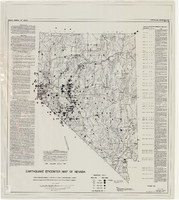
Earthquake epicenter map of Nevada, December 1964
Date
1964-12
Description
Scale 1:1,000,000 (W 120°--W 114°/N 42°--N 35°). Title in upper right margin: Earthquake epicenter map ; "Nevada earthquake epicenters for the period from about 1852 to 1961 are plotted on the accompanying map." ; "Contour interval 1,000 feet." ; "Supported by grant no. AF-AFOSR-62-285 of the Air Force of Scientific Research." ; "December 1964." ; "Base from NBM Map 17." ; "One million scale set." ; Includes bibliographical references ; Includes text and index. Nevada Bureau of Mines, University of Nevada
Text
"The Archaeology of a C.C.C. Camp in Southern Nevada," Nevada History Conference, Reno, Nevada, 1989
Level of Description
File
Archival Collection
University of Nevada, Las Vegas Faculty Publications
To request this item in person:
Collection Number: UA-00056
Collection Name: University of Nevada, Las Vegas Faculty Publications
Box/Folder: Box 09
Collection Name: University of Nevada, Las Vegas Faculty Publications
Box/Folder: Box 09
Archival Component
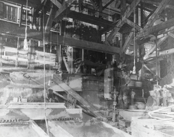
Sunnyside Mill in Round Mountain, Nevada: photographic print
Date
1905
Archival Collection
Description
From the Nye County, Nevada Photograph Collection (PH-00221) -- Series V. Smoky Valley, Nevada and Round Mountain, Nevada -- Subseries V.C. Lofthouse-Berg Families (Round Mountain)
Image