Search Results
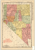
Map of Nevada Railroads, 1904
Date
Description
Image
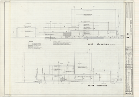
Architectural drawings of Fine Arts Building, University of Nevada Southern Regional Branch, Las Vegas, Nevada, east and north exterior elevations, July 15, 1963
Date
Archival Collection
Description
East and north exterior elevations of the Fine Arts Building (later to become the Judy Bayley Theatre) at the University of Nevada Southern Regional Branch, Las Vegas, Nevada (later University of Nevada, Las Vegas). Scale: 1/8" = 1'-0". "Sheet A-9 of 26." "Drawn: JM. Checked: JBM. Date 10 July 63. Submittal dates: preliminary 12-7-62; intermediate 3-17-63; final 7-15-63." "Bolt , Beranek and Newman Inc., consultants in acoustics. D'autremont-Helms & Assoc., consulting mechanical engineers. Helin Engineering Co., electrical engineers." "Fund code no. 82301." "State of Nevada Planning Board, Carson City, Nevada."
Site Name: University of Nevada. Southern Regional Division
Address: 4505 S. Maryland Parkway
Image
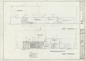
Architectural drawings of Fine Arts Building, University of Nevada Southern Regional Branch, Las Vegas, Nevada, west and south exterior elevations, July 15, 1963
Date
Archival Collection
Description
West and south exterior elevations of the Fine Arts Building (later to become the Judy Bayley Theatre) at the University of Nevada Southern Regional Branch, Las Vegas, Nevada (later University of Nevada, Las Vegas). Scale: 1/8" = 1'-0". "Sheet A-10 of 26." "Drawn: JM. Checked: JBM. Date 10 July 63. Submittal dates: preliminary 12-7-62; intermediate 3-17-63; final 7-15-63." "Bolt , Beranek and Newman Inc., consultants in acoustics. D'Autremont-Helms & Assoc., consulting mechanical engineers. Helin Engineering Co., electrical engineers." "Fund code no. 82301." "State of Nevada Planning Board, Carson City, Nevada."
Site Name: University of Nevada. Southern Regional Division
Address: 4505 S. Maryland Parkway
Image
Haller, Mark H. Bootleggers as Businessmen: From City Slums to City Builders, Law, Alcohol, and Order: perspectives on national prohibition, approximately 1900 to 1999
Level of Description
Archival Collection
Collection Name: UNLV Libraries Collection of Articles on Gaming and Las Vegas, Nevada Topics
Box/Folder: Box 19
Archival Component
Butterfield, Roger. Harold's Club: Country's biggest gambling joint run by Smith family of Reno, Life 19(16), approximately 1900 to 1999
Level of Description
Archival Collection
Collection Name: UNLV Libraries Collection of Articles on Gaming and Las Vegas, Nevada Topics
Box/Folder: Box 10
Archival Component
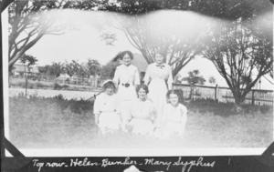
Film transparency of Helen Bunker, Mary Syphus, Florence Bishop, Zella Peterson, and Wanda Ball, presumably in Las Vegas, circa early 1900s
Date
Archival Collection
Description
Image
"Fishing trip near Moapa. Early Las Vegans: Ray Mosbach family, Jim Adams family, Leon Rockwell, Sr. family" (written on verso): photographic print, approximately 1915 to 1925
Level of Description
Archival Collection
Collection Name: Leon Rockwell Photograph Collection
Box/Folder: Folder 20
Archival Component

Map of the state of Nevada to accompany the annual report of the Commr. Genl. Land Office, October 2, 1866
Date
Description
Image

Map showing location of the Las Vegas & Tonopah Railroad from Las Vegas to Bullfrog, Nevada, 1906
Date
Archival Collection
Description
Image
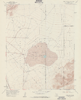
Topographic map of Frenchman Flat quadrangle, Nevada, 1960
Date
Description
For sale by the U.S. Geological Survey
Image