Search Results
Baskett, Bob. The sports basket: Reizner racks up winner, Los Angeles Herald Examiner, approximately 1900 to 1999
Level of Description
File
Archival Collection
UNLV Libraries Collection of Articles on Gaming and Las Vegas, Nevada Topics
To request this item in person:
Collection Number: MS-00626
Collection Name: UNLV Libraries Collection of Articles on Gaming and Las Vegas, Nevada Topics
Box/Folder: Box 06
Collection Name: UNLV Libraries Collection of Articles on Gaming and Las Vegas, Nevada Topics
Box/Folder: Box 06
Archival Component
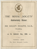
The Royal Society anniversary dinner menu, St. Andrew's day, November 30, 1900, at the Hôtel Métropole, Whitehall Rooms
Date
1900-11-30
Archival Collection
Description
Note: Sir William Huggins, K.C.B., presiding Menu insert: Toasts; Wine lists Restaurant: The Hôtel Métropole (London, England). Whitehall Rooms Location: London, England
Text

Map of Las Vegas Rancho, Lincoln County, Nevada, September 15, 1904
Date
1904-09-15
Description
'Being part of Township 20 S. R.61 E. MT. D. B.&.M, containing 1864.49 acres. Division engineer's office at the front, AMB, September 15th, 1904. A.L. Jones, Division Engineer. Surveyed by W.G. Watson, Assistant Engineer. Dwg. 30296.' Includes traverse table. Shows land owned by the San Pedro, Los Angeles & Salt Lake Railroad, its right of way and the right of way for the Las Vegas & Tonopah Railroad, land owned by the Las Vegas Land & Water Company including Clark's Las Vegas Townsite with the Bucks Addition and the Wardie Addition, and parcels sold from the Las Vegas Land & Water Company land. Scale: [1:9,600]. 1 in. to 800 feet. Library's copies 1 and 4 have land owned by the San Pedro, Los Angeles & Salt Lake Railroad hand-colored in pink and the rest of the Las Vegas Rancho not owned by the Las Vegas Land & Water Company hand-colored in green. Library's copy 2 has buildings of the Stewart Ranch drawn in and labeled in pencil. Library's copy 3 has addition and subtraction problems in pencil on the verso. Library's copy 4 has "Original purchase--1864.49 acres R.R.C. + L.V.L. + W. Co.--In colors." written in pencil on the verso followed by "(1904)" in red pencil. Library's copy 4 also has label on verson made of brown paper with "No 5 Las Vegas Ranch being part township ( 1904)" typed on it.
Image
"Upper Main Street" Teams of burros wait near loaded carts, Tonopah Trading Co. on the left, men and women are walking down the street, Tonopah, Nevada: glass plate negative, approximately 1900 to 1909
Level of Description
Item
Archival Collection
E. W. Smith Glass Plate Negatives
To request this item in person:
Collection Number: PH-00460
Collection Name: E. W. Smith Glass Plate Negatives
Box/Folder: Box 02
Collection Name: E. W. Smith Glass Plate Negatives
Box/Folder: Box 02
Archival Component
Fred Malcolm and his Friends. London: Wells Gardner, Darton & Co., approximately 1900 to 1909
Level of Description
Item
Archival Collection
Mavis Eggle "Books as They Were Bought" Collection
To request this item in person:
Collection Number: MS-01144
Collection Name: Mavis Eggle "Books as They Were Bought" Collection
Box/Folder: No Container 00
Collection Name: Mavis Eggle "Books as They Were Bought" Collection
Box/Folder: No Container 00
Archival Component
A Millionaire of Yesterday by Oppenheim, E. Phillips . London: Ward, Lock, & Co., Limited, approximately 1900 to 1909
Level of Description
Item
Archival Collection
Mavis Eggle "Books as They Were Bought" Collection
To request this item in person:
Collection Number: MS-01144
Collection Name: Mavis Eggle "Books as They Were Bought" Collection
Box/Folder: No Container 00
Collection Name: Mavis Eggle "Books as They Were Bought" Collection
Box/Folder: No Container 00
Archival Component
A sixteenth century anthology by Symons, Arthur (edited by). Blackie & Son Limited, approximately 1900 to 1909
Level of Description
Item
Archival Collection
Mavis Eggle "Books as They Were Bought" Collection
To request this item in person:
Collection Number: MS-01144
Collection Name: Mavis Eggle "Books as They Were Bought" Collection
Box/Folder: No Container 00
Collection Name: Mavis Eggle "Books as They Were Bought" Collection
Box/Folder: No Container 00
Archival Component
A Dead Certainty by Gould, Nat. London: George, Routledge & Sons, Ltd., approximately 1900 to 1909
Level of Description
Item
Archival Collection
Mavis Eggle "Books as They Were Bought" Collection
To request this item in person:
Collection Number: MS-01144
Collection Name: Mavis Eggle "Books as They Were Bought" Collection
Box/Folder: No Container 00
Collection Name: Mavis Eggle "Books as They Were Bought" Collection
Box/Folder: No Container 00
Archival Component