Search Results
"Newspaper Accounts of Indian Women in Southern Nevada Mining Towns, 1870-1900." Journal of California and Great Basin Anthropology, vol. 8, no. 1 (1986): 83-98, 1986
Level of Description
File
Archival Collection
University of Nevada, Las Vegas Faculty Publications
To request this item in person:
Collection Number: UA-00056
Collection Name: University of Nevada, Las Vegas Faculty Publications
Box/Folder: Box 06
Collection Name: University of Nevada, Las Vegas Faculty Publications
Box/Folder: Box 06
Archival Component
J. Ross Clark, Miriam Clark, and James Ross Clark II: photographic prints and negatives, approximately 1900 to 1920
Level of Description
File
Archival Collection
J. Ross Clark Photograph Collection
To request this item in person:
Collection Number: PH-00144
Collection Name: J. Ross Clark Photograph Collection
Box/Folder: Folder 01, Box SH-023, Binder PB-003
Collection Name: J. Ross Clark Photograph Collection
Box/Folder: Folder 01, Box SH-023, Binder PB-003
Archival Component
Home Notes: the Ideal Paper for the Ideal Home, vol. 525, no. 1626. London: Newnes & Pearson Publishing Co., 1925 March 07
Level of Description
Item
Archival Collection
Mavis Eggle "Books as They Were Bought" Collection
To request this item in person:
Collection Number: MS-01144
Collection Name: Mavis Eggle "Books as They Were Bought" Collection
Box/Folder: Box 30
Collection Name: Mavis Eggle "Books as They Were Bought" Collection
Box/Folder: Box 30
Archival Component
People picnicking in the desert. Handwritten inscription given with photograph: "Aunt Alma, Earl, Mother, Floyd, Bessie, Alley Lawson": photographic print, approximately 1915 to 1925
Level of Description
Item
Archival Collection
Leon Rockwell Photograph Collection
To request this item in person:
Collection Number: PH-00008
Collection Name: Leon Rockwell Photograph Collection
Box/Folder: Folder 10
Collection Name: Leon Rockwell Photograph Collection
Box/Folder: Folder 10
Archival Component
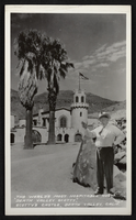
Postcard showing Scotty's Castle and Death Valley Scotty, Death Valley, California, circa mid 1900s
Date
1920 to 1959
Archival Collection
Description
An image composed of Scotty's Castle, Death Valley Scotty, and a stone covered in petroglyphs. Located within the far northern region of Death Valley in Grapevine Canyon, the Death Valley Ranch, more commonly known as Scotty's Castle, is a prime example of Spanish-Mediterranean styling during the Roaring 1920s and Depression of the 1930s. Death Valley Scotty was a prospector, performer, and con man who was made famous by his scams involving gold mining near Death Valley. The petroglyph-covered rock beside Death Valley Scotty was designed by Native Americans who inhabited the valley hundreds of years ago. Transcribed across the bottom of the image: "The world's most hospitable host, Death Valley Scotty," Scotty's Castle, Death Valley, Calif."
Image

Map of Las Vegas, Nevada, July 1947
Date
1947
Description
'Prepared by Porter & White Agency. Typography by Marc Wilkinson.' 'Travel-Aid. A Ballinger publication, copyright, July 1947.' Panel title: 'Las Vegas, Nevada invites you! : see Boulder Dam, Lake Mead.' Includes information on Las Vegas, business directory, advertisements and directory of service clubs. Advertisements, map of Boulder City, and map of southern Nevada area with advertisements on verso. Ballinger Publishing Company.
Text

Geologic map of the Lathrop Wells quadrangle, Nye County, Nevada, 1970
Date
1970
Description
58 x 47 cm., on sheet 74 x 84 cm., folded in envelope 30 x 24 cm. Relief shown by contours and spot heights. "Bedrock geology mapped by B.C. Burchfiel, 1961, and by E.J. McKay and K.A. Sargent, 1965-66. Surficial geology mapped by A.T. Fernald, 1968." Includes cross sections, description of map units, and location map. "Prepared in cooperation with the U. S. Atomic Commission." Original publisher: Interior, Geological Survey, Series: Geologic quadrangle map GQ, Scale: 1:24 000.
Image

Geologic map of the Topopah Spring quadrangle, Nye County, Nevada, 1970
Date
1970
Description
58 x 46 cm., on sheet 84 x 88 cm., folded in envelope 30 x 24 cm. Relief shown by contours and spot heights. "Geology mapped in 1962-63." Includes description of map units, colored columnar section, 3 colored cross sections, and quadrangle location map. "Prepared in cooperation with the U. S. Atomic Commission." Original publisher: Interior, Geological Survey, Series: Geologic quadrangle map GQ, Scale: 1:24 000.
Image

Geologic map of the Tippipah Spring quadrangle, Nye County, Nevada, 1963
Date
1963
Description
58 x 46 cm., on sheet 84 x 81 cm., folded in envelope 30 x 24 cm. Relief shown by contours and spot heights. "Geology by P.P. Orkild, 1959-60, paleotopography by D.L. Healey and C.H. Miller, 1959-60." Series statement from envelope. Includes description of map units, 2 col. cross sections, and quadrangle location map. "Prepared in cooperation with the U. S. Atomic Commission." Original publisher: Interior, Geological Survey, Series: Geologic quadrangle map GQ, Scale: 1:24 000.
Image

Geologic map of the Ammonia Tanks quadrangle, Nye County, Nevada, 1967
Date
1967
Description
58 x 46 cm., on sheet 84 x 100 cm., folded in envelope 30 x 24 cm. Relief shown by contours and spot heights. "Base by U.S. Geological Survey, 1961." "Geology mapped in 1961-65." "Contour interval 20 feet." Includes 3 col. cross sections, 1 index map, text with bibliography, and quadrangle location map. "Prepared in cooperation with the U. S. Atomic Commission." Original publisher: Interior, Geological Survey, Series: Geologic quadrangle map GQ, Scale: 1:24 000.
Image