Search the Special Collections and Archives Portal
Search Results
Tonopah and Goldfield: materials include an interview, notes, and newspaper clippings about the towns' histories, 1900, 1931-1937, 1947, undated
Level of Description
File
Archival Collection
Byrd Wall Sawyer Collection
To request this item in person:
Collection Number: MS-00316
Collection Name: Byrd Wall Sawyer Collection
Box/Folder: Box 04 (Restrictions apply)
Collection Name: Byrd Wall Sawyer Collection
Box/Folder: Box 04 (Restrictions apply)
Archival Component
"1st airplane came to Las Vegas, O.J. Priest" (written on verso): photographic print and negative, approximately 1900 to 1910
Level of Description
Item
Archival Collection
Leon Rockwell Photograph Collection
To request this item in person:
Collection Number: PH-00008
Collection Name: Leon Rockwell Photograph Collection
Box/Folder: Folder 03, Box SH-015
Collection Name: Leon Rockwell Photograph Collection
Box/Folder: Folder 03, Box SH-015
Archival Component
Windsor's welcome home to Her Majesty's First Life Guards, banquet menu, at the White Hart Hotel, 1900 November 30
Level of Description
Item
Archival Collection
Bohn-Bettoni Menu Collection
To request this item in person:
Collection Number: MS-00793
Collection Name: Bohn-Bettoni Menu Collection
Box/Folder: Box 02
Collection Name: Bohn-Bettoni Menu Collection
Box/Folder: Box 02
Archival Component

Map of the Goldfield Mining District, Nye and Esmeralda Counties, Nevada, 1905
Date
1905
Description
Copyright 1905 by Elmer J. Chute, E.M. Goldfield, Nev. In lower right corner: "Designed and drawn by R.W. Griswold." Includes inset location map; Includes township and range grid. Scale [ca. 1:20, 400. 1 in.=aprrox. 1,700 feet]
Image
The Italian Benevolent Society and the Home for Aged Poor Fund, ball and supper, menu, The Monico, International Hall, 1900 March 07
Level of Description
Item
Archival Collection
Bohn-Bettoni Menu Collection
To request this item in person:
Collection Number: MS-00793
Collection Name: Bohn-Bettoni Menu Collection
Box/Folder: Box 06
Collection Name: Bohn-Bettoni Menu Collection
Box/Folder: Box 06
Archival Component
May Wheeler Bradford’s collection of Chinese artifacts, pre-Boxer rebellion, 1899-1900: photographic print, 1977 July
Level of Description
Item
Archival Collection
Nan Doughty Photograph Collection
To request this item in person:
Collection Number: PH-00240
Collection Name: Nan Doughty Photograph Collection
Box/Folder: Folder 18
Collection Name: Nan Doughty Photograph Collection
Box/Folder: Folder 18
Archival Component
Union Pacific Railroad supporting infrastructure and facilities: contains architectural and structural drawings of turntables and store houses in Los Angeles, California, 1919 June 17-1925 March 20
Level of Description
File
Archival Collection
Union Pacific Railroad Collection
To request this item in person:
Collection Number: MS-00397
Collection Name: Union Pacific Railroad Collection
Box/Folder: Flat File 187
Collection Name: Union Pacific Railroad Collection
Box/Folder: Flat File 187
Archival Component

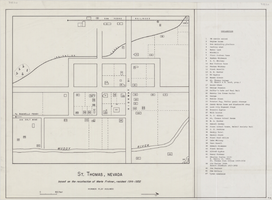
Map of St. Thomas, Nevada, circa 1933
Date
1930 to 1933
Archival Collection
Description
Hand-drawn map of St. Thomas, Nevada (ca. 1914-1932) which was abandoned in 1933 due to the construction of Hoover Dam and is now covered by Lake Mead, as remembered by Merle Frehner (a former resident of St.Thomas). Buildings and residences on map are numbered and explained in a key. "Mormon plat assumed." Scale: 1 1/2 in. = 300 ft.
Image

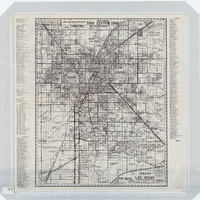
Street map of greater Las Vegas, Nevada, 1965-1966
Date
1965 to 1966
Description
Rev. 1965-1966 ed. 55 x 42 cm., folded to 29 x 12 cm. Panel title: Front Boy's official street map. Relief shown by spot heights. Copyright held by Russell A. Meador. Includes notes, quotations and indexes. Street index on verso. "Detailed guide of North Las Vegas, Las Vegas, Paradise Valley, and vicinity." Original publisher: Meador, Russell A.
Image
Photographs of E.J. Questa and other First National Bank Executives, includes photographs of bank executive and cast of Bonanza at event, 1900-1970
Level of Description
File
Archival Collection
Nevada Banking History Collection
To request this item in person:
Collection Number: MS-00257
Collection Name: Nevada Banking History Collection
Box/Folder: Box 02
Collection Name: Nevada Banking History Collection
Box/Folder: Box 02
Archival Component
Pagination
Refine my results
Content Type
Creator or Contributor
Subject
Archival Collection
Digital Project
Resource Type
Year
Material Type
Place
Language
Records Classification
