Search Results
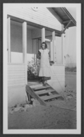
Photograph of Geraldine Stocker, Overton, Nevada, January 1936
Date
1936-01
Archival Collection
Description
Geraldine Stocker in front of the home she helped build near the Overton Mill, Nevada Silica Sand Inc., in Overton, Nevada.
Image
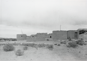
Photograph of Nevada's Lost City, circa 1930s-1940s
Date
1930 to 1949
Archival Collection
Description
A black and white photo of old buildings in the "Lost City" Pueblo Grande de Nevada, which is located near Overton, Nevada.
Image
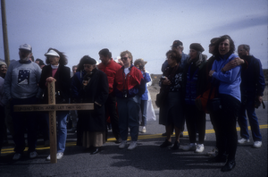
Slide of protesters at a demonstration near the Nevada Test Site, March 8, 1991
Date
1991-03-08
Archival Collection
Description
Color image of protesters with a large wooden cross at an anti-nuclear testing demonstration organized by Lenten Desert Experience (also called Nevada Desert Experience) in the Nevada desert.
Image
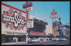
South Virginia Street in Reno, Nevada: postcard
Date
1940 (year approximate) to 1990 (year approximate)
Archival Collection
Description
From the Harvey's Hotel and Casino Postcard Collection (PH-00367) -- The Silver Spur, Horseshoe Club, and Primadonna in Reno, Nevada. South Virginia Street, Biggest Little City in the World. Similar to image 0367_0015.
Image
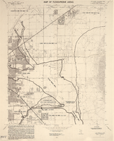
Maps of flood-prone areas in Las Vegas, Nevada, 1973
Date
1973
Description
'Prepared by the U.S. Department of the Interior, Geological Survey, in cooperation with the U.S. Department of Housing and Urban Development, Federal Insurance Administration. 1973.' Sheet 1: Las Vegas NE, Nev.; Sheet 2: Las Vegas SE, Nev.; Sheet 3:Las Vegas SW, Nev.; Sheet 4: Las Vegas NW, Nev. Published by Geological Survey (U.S.). Scale 1:24,000. [1 in. to approx. 2,000 ft.]. Relief shown by contours. Flood information overprinted on U.S. Geological Survey 7.5 minute topographic quadrangles: [sheet 1] Las Vegas NE quadrangle, [sheet 2] Las Vegas SE quadrangle, [sheet 3] Las Vegas SW quadrangle, [sheet 4] Las Vegas NW quadrangle, 1967. Shows areas subject to flooding by a flood that has 1 in 100 chance on the average of occurring in any one year. "Flood boundaries were estimated from: regional stage-frequency relations." Includes notes.
Image

Color view of Frazier Hall at the University of Nevada, Southern Branch (NSU). The name was changed to the University of Nevada, Las Vegas in 1969.
Date
1950 to 1969
Description
Arrangement note: Series V. Glass slidesSite name: University of Nevada, Las Vegas
Image

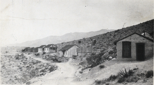
Photograph of Indian Springs, Nevada, circa early 1900s
Date
1900 to 1939
Archival Collection
Description
A street scene in Indian Springs, Nevada.
Image
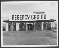
Photograph of the Regency Casino, Laughlin, Nevada, circa 1979
Date
1979 to 1981
Archival Collection
Description
Exterior of the Regency Casino, Laughlin, Nevada.
Image
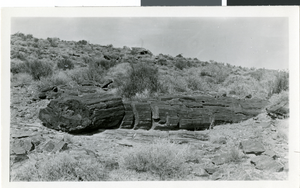
Photograph of Valley of Fire, Nevada, circa 1930s-1950s
Date
1930 to 1959
Archival Collection
Description
Petrified wood in the Valley of Fire, Nevada.
Image