Search Results
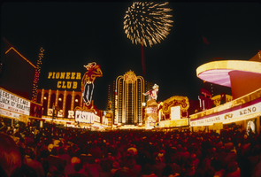
Slide of Fremont Street on New Year's Eve, Las Vegas, circa 1980s
Date
1980 to 1989
Archival Collection
Description
A color image of people celebrating New Year's Eve on Fremont Street in downtown Las Vegas. Fireworks are visible, as are neon signs for Union Plaza, the Pioneer Club's Vegas Vic and the Sassy Sally's Vegas Vicky.
Image
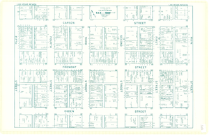
Map of downtown Las Vegas, Nevada, circa 1952-1955
Date
1952 to 1955
Description
Title in upper left and right margins: Las Vegas, Nevada. Identifies business tenants in the downtown area and includes property valuations, measurements, addresses, etc. Cadastral map. Oriented with north to the lower right.Text, illustrations, aerial photos, and ancillary map of the Las Vegas Strip on verso. Cataloger has determined date of map to be between 1952 and 1955 because the Sahara and the Sands Casinos are shown on the verso of the map, and they both opened in 1952, but the Riviera and the Dunes opened in 1955, and they are not shown on the map. Also, the Hotel Last Frontier is shown on the verso of the map, and its name was changed to New Frontier in 1955. Note: Many of the property names and addresses are erroneous when compared to Las Vegas business directories from the same period.
Image
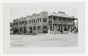
Photograph of Hotel Nevada, Las Vegas (Nev.), 1912
Date
1912
Archival Collection
Description
Site Name: Hotel Nevada (Las Vegas, Nev.)
Image
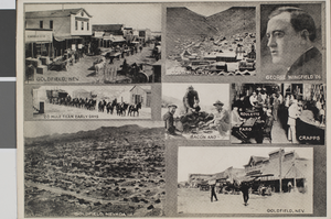
Postcard of scenes of Goldfield, Nevada and Gold Hill, Nevada, circa 1910s
Date
1910 to 1919
Archival Collection
Description
A picture postcards with photographs of Goldfield, Nevada, Gold Hill, Nevada, George Wingfield in 1906, a 20-mule team, miners eating bacon around a campfire, and a gambling hall where men are playing roulette, faro and craps.
Image
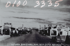
Film transparency of Nevada Boulevard, Boulder City, Nevada, circa 1931 - late 1930s
Date
1931 to 1939
Archival Collection
Description
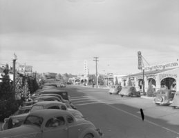
An image of automobiles parked outside of businesses and restaurants on Nevada Boulevard in Boulder City, looking northeast towards the Bureau of Reclamation Administration Building. Hand-printed text on image reads: "Nevada Boulevard, Boulder City, Nevada."
Image
Film transparency of downtown and the Nevada Highway, Boulder City, Nevada, circa 1930-1940
Date
1930 to 1940
Archival Collection
Description
A view of downtown Boulder City and the Nevada Highway.
Image
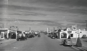
Film transparency of downtown and the Nevada Highway, Boulder City, Nevada, circa 1930-1940
Date
1930 to 1940
Archival Collection
Description
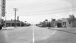
A view of downtown Boulder City and the Nevada Highway. Stores that can be seen include a cafe, a Texaco service gas station, Delmar's Drug shop, and the Reservation Grill.
Image
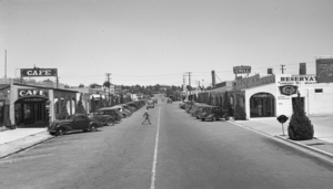
Film transparency of downtown and the Nevada Highway, Boulder City, Nevada, circa 1930-1940
Date
1930 to 1940
Archival Collection
Description
A view of downtown Boulder City and the Nevada Highway. Stores that can be seen include the Nava-Hopi Indian Store, the Green Hut Cafe, the Terminal Building, a Texaco service gas station, and Delmar's Drug.
Image
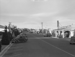
Film transparency of downtown and the Nevada Highway, Boulder City, Nevada, circa 1930-1940
Date
1930 to 1940
Archival Collection
Description
A view of downtown Boulder City and the Nevada Highway. Stores that can be seen include a Texaco service gas station, Delmar's Drug, Reservation Grill, the Nava-Hopi Indian Store, Barber Shop, and the Green Hut Cafe.
Image
Film transparency of downtown and the Nevada Highway, Boulder City, Nevada, circa 1930-1940
Date
1930 to 1940
Archival Collection
Description
A view of downtown Boulder City and the Nevada Highway. Buildings that can be seen include the Nava-Hopi Indian Store, the Green Hut Cafe, the Bureau of Reclamation Administration building, the Terminal Building, a Texaco service gas station, and Delmar's Drug.
Image