Search Results
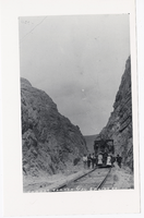
Photograph of the Caliente and Pioche railroad locomotive at Condor Canyon (Nev.), Pioche (Nev.), 1900-1925
Date
1900 to 1925
Archival Collection
Description
Caption: Condor Canyon, Cal. and Pioche RR
Image
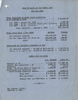
Report on projected cost of water at Las Vegas for year 1930, February 4, 1930
Date
1930-02-04
Archival Collection
Description
Summary of the cost of water for the railroad and the water company in Las Vegas in 1930
Text
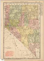
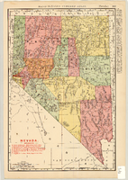
Map showing railroads in Nevada, 1911
Date
1911
Description
Relief shown by hachures. Title below scale: Rand McNally & Co.'s New business atlas map of Nevada. Shows railroads. Includes township and range grid. Includes index to principal cities with population statistics. Includes township and range grid. Index to Nevada counties, lakes, mountains, rivers, towns, etc. on verso. Published by Rand McNally & Co. Scale [ca. 1,710,720]. 1 in. = 27 miles (W 120°--W 114°/N 42°--N 35°). Published as page 321 of Rand-McNally indexed atlas.
Text
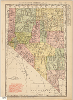
Map of Nevada Railroads, 1911
Date
1911
Description
Scale [ca. 1,710,720]. 1 in. = 27 miles (W 120 --W 114 /N 42 --N 35 ) ; 1 map : col. ; 47 x 31 cm ; Relief shown by hachures ; Title below scale: Rand McNally & Co.'s New business atlas map of Nevada ; Shows railroads ; Includes additional copyright date: c1893 ; Includes township and range grid ; Published as page 321 of Rand-McNally indexed atlas ;
Image
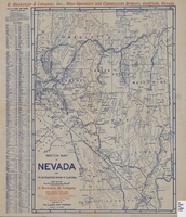
Map of Nevada Railroads, 1904
Date
1904
Description
Scale [ca. 1:1,710,720]. 1 in. equals 27 miles (W 120 --W 114 /N 42 --N 35 ) ; 1 map : col. 47 x 31 cm ; Relief shown by hachures ; Added title: Rand McNally's new business map of Nevada ; Shows range and township grid ; Shows railroads ; Color used to show boundaries of counties ; Originally published as pages 263 and 264 of Rand-McNally indexed atlas ; Additional copyright date: c1893 ;
Image

Map showing railroads in Nevada, 1904
Date
1904
Description
Relief shown by hachures. Added title: Rand McNally's new business map of Nevada. Shows range and township grid. Shows railroads. Color used to show boundaries of counties. Includes index to cities. On verso: Indexes to counties, lakes, mountains, rivers, towns, etc. Published by Rand McNally & Co. Scale [ca. 1:1,710,720]. 1 in. equals 27 miles (W 120°--W 114°/N 42°--N 35°). Originally published as pages 263 and 264 of Rand-McNally indexed atlas.
Text
Sketch map of Nevada and the southeastern portion of California, 1906
Date
1906
Description
42 x 30 cm., fold. to 23 x 11 cm. Relief shown by hachures. Copyright: George S. Clason. "Compliments of D. Mackinzie & Company Incorporated, Mine Operators and Commission Brokers, Goldfield, Nevada." Company's locations in Goldfield and in Greenwater, California, are marked with red circles on the map. Includes index. Shows railroad routes. Original publisher: Clason Map Co..
Image

Map of Las Vegas Rancho, Lincoln County, Nevada, September 15, 1904
Date
1904-09-15
Description
'Being part of Township 20 S. R.61 E. MT. D. B.&.M, containing 1864.49 acres. Division engineer's office at the front, AMB, September 15th, 1904. A.L. Jones, Division Engineer. Surveyed by W.G. Watson, Assistant Engineer. Dwg. 30296.' Includes traverse table. Shows land owned by the San Pedro, Los Angeles & Salt Lake Railroad, its right of way and the right of way for the Las Vegas & Tonopah Railroad, land owned by the Las Vegas Land & Water Company including Clark's Las Vegas Townsite with the Bucks Addition and the Wardie Addition, and parcels sold from the Las Vegas Land & Water Company land. Scale: [1:9,600]. 1 in. to 800 feet. Library's copies 1 and 4 have land owned by the San Pedro, Los Angeles & Salt Lake Railroad hand-colored in pink and the rest of the Las Vegas Rancho not owned by the Las Vegas Land & Water Company hand-colored in green. Library's copy 2 has buildings of the Stewart Ranch drawn in and labeled in pencil. Library's copy 3 has addition and subtraction problems in pencil on the verso. Library's copy 4 has "Original purchase--1864.49 acres R.R.C. + L.V.L. + W. Co.--In colors." written in pencil on the verso followed by "(1904)" in red pencil. Library's copy 4 also has label on verson made of brown paper with "No 5 Las Vegas Ranch being part township ( 1904)" typed on it.
Image

Map showing location of the Las Vegas & Tonopah Railroad from Las Vegas to Bullfrog, Nevada, 1906
Date
1906
Archival Collection
Description
'Office of Chief Engineer' printed on map above date.
Image
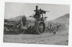
Photograph of the Southern Nevada Forwarding Company steam train near the railyards, Goldfield (Nev.), 1904
Date
1904
Archival Collection
Description
Caption: Freight lifting by traction to Goldfield
Image