Search Results
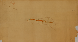
Map of the Red Top Mine, 1st level, Washoe County (Nev.), 1900-1925
Date
1900 to 1925
Description
Sectional mining map; hand-drawn and annotated in colored pencil
Image
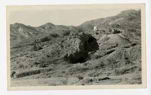
Photograph of the hillside and surface stopes at the Wall Street Mine, Eldorado Canyon (Nev.), 1900-1925
Archival Collection
Description
Inscription on back reads: Room and pillar surface stopes stopes on the Wall Street Mine-which produced $1,5000,000.00 in gold alone from about 80 feet depth. El Dorado Canyon Clark County Nevada
Image
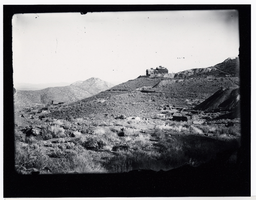
Photograph of the Burke Mine tunnel area and store atop a hill, Pioche (Nev.), 1900-1925
Date
1900 to 1925
Archival Collection
Description
View of Burke Tunnel area-building at top of hill was store for Burke tunnel. #93 on left, some buildings on left remain, 1982. Photo 1900-1910. Pioche, Nev. ID by Vic Cottino/Jerome Sears July 1982
Image
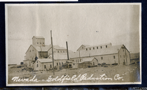
Photograph of the Nevada-Goldfield Mill operations, Goldfield (Nev.), 1900-1920
Date
1900 to 1920
Archival Collection
Description
Caption: Nevada-Goldfield Reduction Co.
Image

Map of Las Vegas, Nevada and surrounding Bureau of Land Management areas to the west and north, 1994
Date
1994
Description
'BLM edition, 1994.' 'Surface management status; mineral management status.' '1:100,000-scale topographic map showing highways, roads and other manmade structures; water features; contours and elevations in meters with conversions to feet; BLM recreation sites.' 'Edited and published by the Bureau of Land Management. Base map prepared by the U.S. Geological Survey.' I53:11/4-2
Text
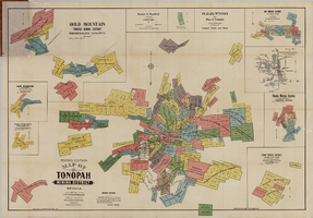
Map of Tonopah Mining District, Nevada, revised edition, 1903
Date
1903
Description
'Compiled and published by Booker & Bradford, engineers, Tonopah, Nevada.' 'Copyrighted by Booker & Bradford 1903.' 'Photo-Lith. Britton & Rey, S.F.' Insets of Ray Mining District, vicinity map of Tonopah Mining District, Utopia Mining District, Tokop Mining District, Weepah Mining District, East Klondike Mining District, Gold Mountain, Tonopah Mining District and Red Mountain. Relief shown by hachures. Includes advertisements. Scale [ca. 1:10,800]. 1 inch to 900 feet.
Image

Tonopah, Nevada mining map, March 1904
Date
1904-03
Description
'U.S. Geological Survey, George Otis Smith, Director.' 'R.U. Goode, Geographer in charge. Triangulation by U.S. Coast and Geodetic Survey. Topography by W.J. Peters. Surveyed in 1902-1903.' 'Edition of Mar. 1904, reprinted Apr. 1910.' Oriented with north toward the upper left. Relief shown by contours and hachures. Scale 1:12,000 (W 117°14´--W 117°12´/N 38°05´--N 38°03´)
Text

Map of the state of Nevada to accompany the annual report of the Commr. Genl. Land Office, October 2, 1866
Date
1866-10-02
Description
'Department of the Interior, General Land Office, October 2nd, 1886, [signed] Jos. S. Wilson, Commissioner.' 'The Major & Knapp Eng. Mfg. & Lith. Co. 71 Broadway, N.Y.' Relief shown by hachures. Hand colored. Shows silver, gold, and copper mines. Scale [1:1,140,480]. 18 miles to an in. (W 120°--W 114°/N 42°--N 35°)
Image
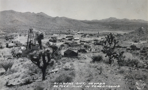
Postcard showing Searchlight, Nevada, circa 1930s
Date
1930 to 1939
Archival Collection
Description
The view of the small town of Searchlight, Nevada. Formed in 1897, Searchlight is an old boomtown that was made popular when George Frederick Colton discovered gold at the location where the town is now built. Unnamed buildings cluster together in the center of the postcard while rocky terrain decorated with small shrubs and mines surround the city's outskirts. Transcribed onto the bottom of the postcard: "Searchlight, Nevada; Duplex Mine In Foreground." The Frasher's Foto logo is also printed onto the bottom right corner.
Image
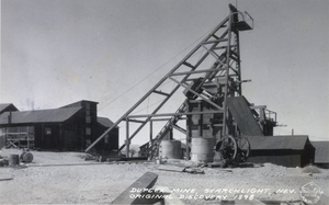
Postcard showing Searchlight, Nevada, circa 1930s
Date
1930 to 1939
Archival Collection
Description
The view of Duplex Mine in Searchlight, Nevada. Founded in 1897, Searchlight is an old boomtown that was made popular when George Frederick Colton discovered gold at the location where the town is now built. At the Duplex mine discovered in 1898, a windowed building lies to to left of some machinery used for mining. Transcribed across the bottom of the image: "Duplex Mine, Searchlight, Nev. Original Discovery 1898." The Frasher's Foto logo is printed on the bottom right corner.
Image