Search Results
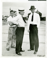
Photograph of Howard Hughes and W.D. "Jim" Guthrive at Roosevent Field, New York, July 18, 1938
Date
1938-07-18
Archival Collection
Description
Handwritten on the back of the image: "Talking to W.D. "Jim" Guthrive at Roosevelt Field. 7/18/38."
Image
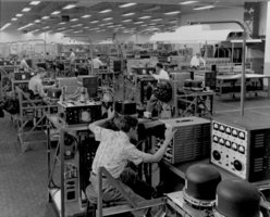
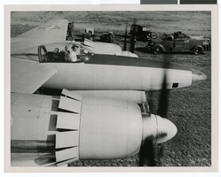
Photograph of radar testing at the Hughes Aircraft Company, Culver City, California, 1959
Date
1959
Archival Collection
Description
Engineers test radar equipment at the Hughes Aircraft Company in 1959.
Image
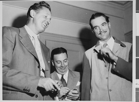
Photograph of Howard Hughes with Senator Harry P. Cain, Culver City, California, August 16, 1947
Date
1947-08-16
Archival Collection
Description
A view of Howard Hughes (right) being asked about his controversial XF-11 photo reconnaissance plane by Senator Harry Cain (left), Republican of Washington, in Culver City, California. An unidentified man sits between the two.
Image

Map of California, Utah, Nevada, Colorado, New Mexico and Arizona, 1864
Date
1864
Description
'Johnson's California, with Utah, Nevada, Colorado, New Mexico, and Arizona, published by Johnson and Ward.' 'Entered according to Act of Congress in the Year 1864 by A.J. Johnson in the Clerks Office of the District Court of the United States for the southern district of New York.' Atlas page numbers in upper margin: 66-67. This is probably plate 67 from Johnson's New Illustrated Family Atlas, published in New York by Johnson & Ward in 1864. Shows natural features, locations of Indian tribes, proposed railroad routes, routes of explorers, trails, county boundaries and populated places ; "." ; Relief shown by hachures ; Prime meridians: Greenwich and Washington ; In top margin: 66-67 ; Hand colored ; On verso: Historical and statistical view of Mexico and central America (p. 79) and Historical and statistical view of the United States, 1860 (p. 78) Scale [ca. 1:3,484,800]. 1 in. to ca. 55 miles (W 124°--W 102°/N 42°--N 32°)
Text

Photograph of Howard Hughes' plane at Floyd Bennet Airfield, New York, August 20, 1938
Date
1938-08-20
Archival Collection
Description
Description given with photograph: "Hughes sets new transcontinental transport mark. Floyd Bennet Field, NY--- Howard Hughes, millionaire flier, setting his famous round-the-world transport plane down here, early August 20th, after a record-smashing flight from Los Angeles. Hughes and three companions completed the trip in 10 hours 32 minutes and 20 seconds, shattering the record of 11 hours and five minutes set four years ago by Tommy Tomlinson. The flight was made most of the way in the substratosphere at an average altitude of 17, 000 feet. Credit Line ACME."
Image
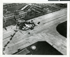
Photograph of the landing of Howard Hughes' Lockheed 14 aircraft, New York, July 14, 1938
Date
1938-07-14
Archival Collection
Description
The black and white, aerial view of Howard Hughes' Lockheed 14 aircraft after performing its final landing on the Round the World flight at Floyd Bennett Airport, New York. Typed onto a piece of paper attached to the image: "Crowds welcome round the world flyers at Floyd Bennett Field 7/14/38. (Press Association)"
Image
Report: "Marketing Casino Gambling and a Local Lottery in New York City" by the Council of the City of New York for the Committee on Economic Development, 1991
Level of Description
File
Archival Collection
Eugene Martin Christiansen Papers
To request this item in person:
Collection Number: MS-00561
Collection Name: Eugene Martin Christiansen Papers
Box/Folder: Box 163
Collection Name: Eugene Martin Christiansen Papers
Box/Folder: Box 163
Archival Component

City map of Las Vegas, 1973
Date
1905-05-26
Description
Color; 55 x 45 cm., on sheet 95 x 47 cm., folded to 24 x 10 cm. Panel title: Las Vegas city map. Copyright held by Cardinal Publishing Company. Relief shown by hachures. Includes illustrations and advertisements. Index, text, illustrations, advertisements, and map of "Lake Mead National Recreation Area, lower basin section" on verso. Original publisher: Cardinal Publishing Company.
Image
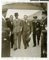
Photograph of Howard Hughes and Grover Whalen at Floyd Bennett Airfield, New York, July 14, 1938
Date
1938-07-14
Archival Collection
Description
A view of Howard Hughes being escorted by Grover Whalen and several guards at Floyd Bennett Airfield.
Image
Photograph of Howard Hughes in the cockpit of the XF-11, Culver City, California, July 7, 1946
Date
1946-07-07
Archival Collection
Description
Transcribed from back of photo: "Howard Hughes (in cockpit) warms up the XF-11 for its initial test flight. It is one of the world's fastest long-range photographic planes, July 7, 1946."
Image