Search Results
Howard Hughes and the Lockheed 14 aircraft, Fairbanks, Alaska, 1938 July 15
Level of Description
File
Archival Collection
Howard Hughes Public Relations Photograph Collection
To request this item in person:
Collection Number: PH-00373
Collection Name: Howard Hughes Public Relations Photograph Collection
Box/Folder: Folder 07
Collection Name: Howard Hughes Public Relations Photograph Collection
Box/Folder: Folder 07
Archival Component
Howard Hughes at the celebration of his around-the-world flight, 1938 July 15
Level of Description
File
Archival Collection
Howard Hughes Public Relations Photograph Collection
To request this item in person:
Collection Number: PH-00373
Collection Name: Howard Hughes Public Relations Photograph Collection
Box/Folder: Folder 12
Collection Name: Howard Hughes Public Relations Photograph Collection
Box/Folder: Folder 12
Archival Component
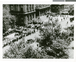
Photographs of crowds at Around-the-World-Flight Parade, New York City (N.Y.), July 15, 1938
Date
1938-07-15
Archival Collection
Description
Crowd at a parade in New York City celebrating the completion of Howard Hughes' Around-the-World Flight!
Image
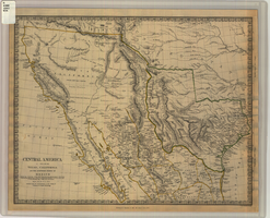
Map of Texas, California, New Mexico and the northern states of Mexico, October 15, 1842
Date
1842-10-15
Description
'Published under the superintendence of the Society for Diffusion of Useful Knowledge.' 'Published by Chapman & Hall, 186 Strand, 15 Oct. 1842.' 'J. & C. Walker, Sculpt.' Scale [ca. 1:7,600,000]. 1 in. to ca. 120 miles (W 125°--W 91°/N 43°--N 23° 30?). 1 map ; 31 x 39 cm. Relief indicated by hachures and spot heights. Shows elevations in yards. Includes notes on exploring expeditions, etc. Borders hand colored. Chapman & Hall.
Image

Map of California, Nevada, Utah, Colorado, Arizona & New Mexico, circa 1867
Date
1865 to 1869
Description
39 x 62 cm. Relief shown by hachures and spot heights. Prime meridian: Greenwich and Washington. Hand colored. Shows natural features, populated places, routes of mail steamships, routes of explorers, locations of Indian tribes, railroad routes, and proposed railroad routes. In top margin: No. 80-81. On verso: New Mexico, Arizona, Colorado, Idaho, Dakota (statistics and other information) and The state of California (statistics and other information). Original publisher: G.W. and C.B. Colton.
Image
Adamar of New Jersey License Application, December 15, 1981
Level of Description
File
Archival Collection
International Association of Gaming Attorneys Collection
To request this item in person:
Collection Number: MS-00250
Collection Name: International Association of Gaming Attorneys Collection
Box/Folder: Box 01
Collection Name: International Association of Gaming Attorneys Collection
Box/Folder: Box 01
Archival Component
Hughes/Echostar Video News Release Corporate Announcement- New Master, 2002 March 07
Level of Description
File
Archival Collection
Hughes Electronics Corporation Records
To request this item in person:
Collection Number: MS-00485
Collection Name: Hughes Electronics Corporation Records
Box/Folder: Box 14
Collection Name: Hughes Electronics Corporation Records
Box/Folder: Box 14
Archival Component
Global Works Hughes Electronic Corporation Corporate Runner New AO, 2000 October 23
Level of Description
File
Archival Collection
Hughes Electronics Corporation Records
To request this item in person:
Collection Number: MS-00485
Collection Name: Hughes Electronics Corporation Records
Box/Folder: Box 16
Collection Name: Hughes Electronics Corporation Records
Box/Folder: Box 16
Archival Component

Map of California, and territories of Utah, Nevada, Colorado, New Mexico and Arizona, 1864
Date
1864
Description
'Johnson's California, also Utah, Nevada, Colorado, New Mexico, and Arizona, published by A.J. Johnson, New York.' 'Entered according to act of Congress in the year 1864, by A.J. Johnson in the Clerks Office of the District Court of the United States for the southern district of New York.' Atlas page numbers in upper margin: 67-68. Relief shown by hachures. Prime meridian: Greenwich and Washington. Shows natural features, locations of Indian tribes, proposed railroad routes, routes of explorers, trails, county boundaries and populated places. Hand colored. On verso: 'Historical and statistical view of the West India Islands or Columbian Archipelago' (p. 80) and 'Historical and statistical view of Mexico and Central America' (p. 79). Scale [ca. 1:3,484,800]. 1 in. to ca. 55 miles (W 124°--W 102°/N 42°--N 32°).
Text