Search Results
Music Hall New Years Eve Gala Dinner 1969-1970, menu, 1969
Level of Description
File
Archival Collection
UNLV University Libraries Menu Collection
To request this item in person:
Collection Number: MS-00436
Collection Name: UNLV University Libraries Menu Collection
Box/Folder: Box 13
Collection Name: UNLV University Libraries Menu Collection
Box/Folder: Box 13
Archival Component

Map of California, with territories of Utah, Nevada, Colorado, New Mexico, and Arizona, 1864
Date
1864
Description
40 x 62 cm. Relief shown by hachures. Prime meridians: Greenwich and Washington. Page numbers at top: 58-59. "Entered according to act of Congress in the year 1864 by A. J. Johnson in the Clerk's Office of the District Court of the United States for the Southern District of New York." Original publisher: Johnson and Ward.
Image
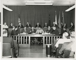
Photograph of a contract signing at City Hall, Las Vegas (Nev.), August 25, 1967
Date
1967-08-25
Archival Collection
Description
Signing of contracts for Lake Mead water pipeline at the Las Vegas City Hall. Sitting in the top row from left to right: unidentified individual, Arleigh West, Bureu of Reclamation, Oran Gragson, Mayor of Las Vegas, Paul Laxalt, Governor of Nevada, Robert Griffith, Chairman Colorado River Commission, William Taylor, Mayor of North Las Vegas, Leonard Fayle, President of Las Vegas Valley Water District, Mr. Hampton, Mayor of Henderson, Robert Broadbent, Mayor of Boulder City. Site Name: Clark County Court House, Las Vegas (Nev.)
Image
Harrah's Grand, Atlantic City, New Jersey, 2001
Level of Description
File
Archival Collection
Robert Beckmann Photographs
To request this item in person:
Collection Number: PH-00381
Collection Name: Robert Beckmann Photographs
Box/Folder: Box 02
Collection Name: Robert Beckmann Photographs
Box/Folder: Box 02
Archival Component
North Las Vegas City Hall construction: digital photographs, 2010 October 04
Level of Description
File
Archival Collection
Bill Hughes Photographs
To request this item in person:
Collection Number: PH-00402
Collection Name: Bill Hughes Photographs
Box/Folder: Digital File 00
Collection Name: Bill Hughes Photographs
Box/Folder: Digital File 00
Archival Component
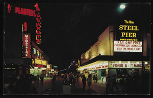
Nighttime view of Atlantic City, New Jersey: postcard
Date
1940 (year approximate) to 1990 (year approximate)
Archival Collection
Description
From Harvey's Hotel and Casino Postcard Collection (PH-00367)
Image
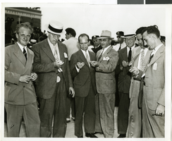
Photograph of a crowd of people awaiting the arrival of Howard Hughes, New York, July 14, 1938
Date
1938-07-14
Archival Collection
Description
The black and white view of members of the Aeronautical Association awaiting the arrival of Howard Hughes and his Lockheed 12 aircraft at the Floyd Bennett Airport in New York. Typed onto a piece of paper attached to the image: "Official timers of Aeronautical Association compare their precision chronometers as Lockheed-14 roars overhead, marking end of Round-the-World flight at Floyd Bennett Airport." Typed onto a second piece of paper also attached to the image: "Official timers of the Aeronautical Association shown at Floyd Bennett Field comparing their precision chronometers as Howard Hughes' plane roared overhead marking the end of his Flight Around The World. July 1938."
Image
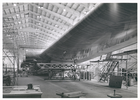
Photograph of the Hughes Flying Boat wing under construction, Culver City, California, June 1, 1945
Date
1945-06-01
Archival Collection
Description
View of construction of one of the wings of the Hughes Flying Boat in a hangar at the Hughes Aircraft Company, June 1, 1945. Scaffolding is seen underneath the wing.
Image

Trinity Church and lower Manhattan from Financial District, New York City, New York: panoramic photograph
Date
1981-05-24
Archival Collection
Description
From the Bob Paluzzi Panoramic Photographs
Image

Map of California, Utah, Nevada, Colorado, New Mexico and Arizona, 1864
Date
1864
Description
'Johnson's California, with Utah, Nevada, Colorado, New Mexico, and Arizona, published by Johnson and Ward.' 'Entered according to Act of Congress in the Year 1864 by A.J. Johnson in the Clerks Office of the District Court of the United States for the southern district of New York.' Atlas page numbers in upper margin: 66-67. This is probably plate 67 from Johnson's New Illustrated Family Atlas, published in New York by Johnson & Ward in 1864. Shows natural features, locations of Indian tribes, proposed railroad routes, routes of explorers, trails, county boundaries and populated places ; "." ; Relief shown by hachures ; Prime meridians: Greenwich and Washington ; In top margin: 66-67 ; Hand colored ; On verso: Historical and statistical view of Mexico and central America (p. 79) and Historical and statistical view of the United States, 1860 (p. 78) Scale [ca. 1:3,484,800]. 1 in. to ca. 55 miles (W 124°--W 102°/N 42°--N 32°)
Text