Search Results

Photograph of Howard Hughes' Northrop Gamma Racer in Newark, New Jersey, January 14, 1936
Date
1936-01-04
Archival Collection
Description
A view of the side of Howard Hughes' Northrop Gamma Racer.
Image
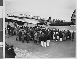
Photograph of Trans World Airline flight, New York, February 15, 1946
Date
1943 to 1945
Archival Collection
Description
Description given with photo: "Non-Stop Los Angeles - New York Flight Inaugurated New York -- View of the crowd around the "Star of California" waiting for passengers -- most of them after it landed at LaGuardia Airport Feb. 15. Piloted by Howard Hughes, famed Around-The-World record holder and a TWA executive, the flight in-augurated non-stop schedule between Los Angeles and New York. The TWA Constellation made the trip in 8 hours and 38 minutes, as compared with the record of 7 hours, 27 minutes. Credit (ACME) 2/15/46."
Image
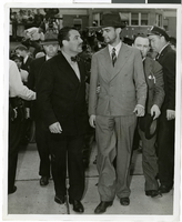
Photograph of Howard Hughes and Grover Whalen at Floyd Bennett Airfield, New York, July 14, 1938
Date
1938-07-14
Archival Collection
Description
A view of Howard Hughes and Grover Whalen at Floyd Bennett Airfield in New York. Description printed on photograph's accompanying sheet of paper: "Grover Whalen greets Hughes. New York City-- His face covered by stubble and still wearing his battered hat, Howard Hughes is taken in tow by Grover Whalen, World's Fair head, shortly after Hughes and his companions set their plane down at Floyd Bennett Airport here, completing their dramatic dash around the world. Credit Line (ACME) 7/14/38"
Image
New York City Center, undated
Level of Description
File
Archival Collection
JMA Architecture Studio Records
To request this item in person:
Collection Number: MS-00783
Collection Name: JMA Architecture Studio Records
Box/Folder: Box 89
Collection Name: JMA Architecture Studio Records
Box/Folder: Box 89
Archival Component
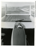
Photograph of Howard Hughes and the XF-11, Culver City, California, July 7, 1946
Date
1946-07-07
Archival Collection
Description
Transcribed from back of photo: "Howard Hughes in the cockpit of the new XF-11 reconnaissance plane which he designed and built in conjuntion with Air Material Command engineers. He is preparing for its first flight. One of the world's fastest long-range photo planes, it can attain a speed of over 400 miles per hour."
Image
Atlantic City, New Jersey: postcard
Date
1940 (year approximate) to 1990 (year approximate)
Archival Collection
Description
From Harvey's Hotel and Casino Postcard Collection (PH-00367)
Image
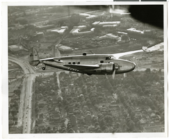
Photograph of the Lockheed 14 aircraft over New York City, July 1938
Date
1938-07
Archival Collection
Description
The black and white view of Howard Hughes plane in flight over New York City, July 1938
Image
Photograph of the Lockheed 14 aircraft over New York City, July 1938
Date
1938-07
Archival Collection
Description
The black and white view of Howard Hughes plane in flight over New York City, July 1938
Image
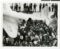
Photograph of Howard Hughes and crowds at Floyd Bennett Airfield, New York, July 14, 1938
Date
1938-07-14
Archival Collection
Description
The black and white view of Howard Hughes and his crew being surrounded by crowds as they exit the Lockheed 14 aircraft after finishing the Around the World flight at Floyd Bennett Airfield in New York.
Image
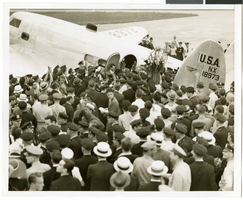
Photograph of Howard Hughes and crowds at Floyd Bennett Airfield, New York, July 14, 1938
Date
1938-07-14
Archival Collection
Description
The black and white view of Howard Hughes and his crew being surrounded by crowds as they exit the Lockheed 14 aircraft after finishing the Around the World flight at Floyd Bennett Airfield in New York.
Image