Search Results
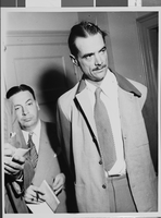
Photograph of Howard Hughes with Senator Harry P. Cain, Culver City, California, August 16, 1947
Date
1947-08-16
Archival Collection
Description
A view of Howard Hughes (right) after being asked about his controversial XF-11 photo reconnaissance plane by Senator Harry Cain (left), Republican of Washington, in Culver City, California.
Image
Howard Hughes at Floyd Bennett Airfield, New York, 1938 July 14
Level of Description
File
Archival Collection
Howard Hughes Public Relations Photograph Collection
To request this item in person:
Collection Number: PH-00373
Collection Name: Howard Hughes Public Relations Photograph Collection
Box/Folder: Folder 09
Collection Name: Howard Hughes Public Relations Photograph Collection
Box/Folder: Folder 09
Archival Component