Search Results
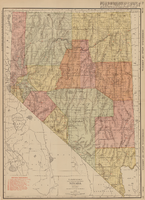
Rand-McNally new commercial atlas map of Nevada, 1912
Date
1912
Description
Original publisher: Rand, McNally & Co. Scale [ca. 1:1,203,840). 1 inch to 19 miles. Originally published as p. 316-317 of Rand McNally's commercial atlas of America. Title in right margin: Nevada : commercial atlas of America. Includes township and range grid. Includes index to Nevada railroads and index to principal cities with their populations. Index on verso to counties, towns and natural features in Oregon and Nevada.
Image
Polaroid of Showboat billboard advertisement, Atlantic City, New Jersey, 1986
Level of Description
Item
Archival Collection
Showboat Atlantic City Photograph Collection
To request this item in person:
Collection Number: PH-00329
Collection Name: Showboat Atlantic City Photograph Collection
Box/Folder: Folder 01
Collection Name: Showboat Atlantic City Photograph Collection
Box/Folder: Folder 01
Archival Component
Interior view of Showboat Casino, Atlantic City, New Jersey, 1986
Level of Description
Item
Archival Collection
Showboat Atlantic City Photograph Collection
To request this item in person:
Collection Number: PH-00329
Collection Name: Showboat Atlantic City Photograph Collection
Box/Folder: Folder 01
Collection Name: Showboat Atlantic City Photograph Collection
Box/Folder: Folder 01
Archival Component
Exterior view of the Showboat Casino, Atlantic City, New Jersey, 1986
Level of Description
Item
Archival Collection
Showboat Atlantic City Photograph Collection
To request this item in person:
Collection Number: PH-00329
Collection Name: Showboat Atlantic City Photograph Collection
Box/Folder: Folder 01
Collection Name: Showboat Atlantic City Photograph Collection
Box/Folder: Folder 01
Archival Component
Construction of the Showboat high-rise, Atlantic City, New Jersey, 1986
Level of Description
Item
Archival Collection
Showboat Atlantic City Photograph Collection
To request this item in person:
Collection Number: PH-00329
Collection Name: Showboat Atlantic City Photograph Collection
Box/Folder: Folder 01
Collection Name: Showboat Atlantic City Photograph Collection
Box/Folder: Folder 01
Archival Component
Exterior view of Showboat Casino, Atlantic City, New Jersey, 1986
Level of Description
Item
Archival Collection
Showboat Atlantic City Photograph Collection
To request this item in person:
Collection Number: PH-00329
Collection Name: Showboat Atlantic City Photograph Collection
Box/Folder: Folder 01
Collection Name: Showboat Atlantic City Photograph Collection
Box/Folder: Folder 01
Archival Component
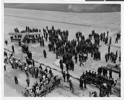
Photograph of a crowd awaiting the arrival of Howard Hughes' plane at Floyd Bennett Airport, New York, July 14, 1938
Date
1938-07-14
Archival Collection
Description
The black and white view of a crowd of people awaiting the arrival Lockheed 14 aircraft at Floyd Bennett Airport in New York. Typed onto a piece of paper attached to the image: "Tumultuous welcome awaits world fliers here Floyd Bennett Airport, N.Y. -- Policemen lined up on the field here awaiting the arrival of Howard Hughes and his companions, New York bound from Minneapolis, on the last leg of their epochal Round-The-World flight. By noon, a crowd of 6,000 persons had gathered at the airport, and it was increasing by the moment. Credit line (ACME). 7/14/38."
Image
Howard Hughes sitting in his XF-11 near Culver City, California, 1946
Level of Description
File
Archival Collection
Howard Hughes Public Relations Photograph Collection
To request this item in person:
Collection Number: PH-00373
Collection Name: Howard Hughes Public Relations Photograph Collection
Box/Folder: Folder 22
Collection Name: Howard Hughes Public Relations Photograph Collection
Box/Folder: Folder 22
Archival Component