Search Results
Howard Hughes sitting in his XF-11 near Culver City, California, 1946
Level of Description
File
Archival Collection
Howard Hughes Public Relations Photograph Collection
To request this item in person:
Collection Number: PH-00373
Collection Name: Howard Hughes Public Relations Photograph Collection
Box/Folder: Folder 22
Collection Name: Howard Hughes Public Relations Photograph Collection
Box/Folder: Folder 22
Archival Component
Lewis, Fred, Letizia & Lewis publicity with president at City Hall, 1989 March 16
Level of Description
File
Archival Collection
Frank Mitrani Photographs
To request this item in person:
Collection Number: PH-00332
Collection Name: Frank Mitrani Photographs
Box/Folder: Box 29
Collection Name: Frank Mitrani Photographs
Box/Folder: Box 29
Archival Component

City of Las Vegas map, 1952
Date
1952
Description
General information on Las Vegas and index on verso ; Copyright held by Redwood Publishing Co. ; Includes inset map of the Strip (U.S. 91 or Los Angeles Highway) ; Redwood Publishing Company
Text

Photograph of Howard Hughes, circa 1938
Date
1938
Archival Collection
Description
A close up portrait of Howard Hughes, possibly in an airplane hangar in New York.
Image
Hugh H. Brown Papers
Identifier
MS-00883
Abstract
The Hugh Henry Brown Papers consist of professional and personal papers (1902-1927) from Hugh Henry Brown, who was a lawyer in Tonopah, Nevada. The professional communication focuses on Brown's law practice dealing primarily with mining and railroad companies in Central Nevada. The papers also contain receipts from purchases made by Brown or his wife, Marjorie Moore Brown.
Archival Collection
Aretha Franklin at Carnegie Hall, New York: costume design drawings, notes, 2003 July-August
Level of Description
File
Archival Collection
Jerry Jackson Papers
To request this item in person:
Collection Number: MS-00573
Collection Name: Jerry Jackson Papers
Box/Folder: Box 07
Collection Name: Jerry Jackson Papers
Box/Folder: Box 07
Archival Component
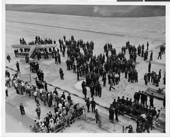
Photograph of a crowd awaiting the arrival of Howard Hughes' plane at Floyd Bennett Airport, New York, July 14, 1938
Date
1938-07-14
Archival Collection
Description
The black and white view of a crowd of people awaiting the arrival Lockheed 14 aircraft at Floyd Bennett Airport in New York. Typed onto a piece of paper attached to the image: "Tumultuous welcome awaits world fliers here Floyd Bennett Airport, N.Y. -- Policemen lined up on the field here awaiting the arrival of Howard Hughes and his companions, New York bound from Minneapolis, on the last leg of their epochal Round-The-World flight. By noon, a crowd of 6,000 persons had gathered at the airport, and it was increasing by the moment. Credit line (ACME). 7/14/38."
Image
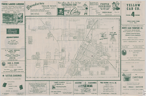
Street map of the city of Las Vegas, 1954
Date
1954
Description
22 x 34 cm. on sheet 36 x 54 cm. Copyright held by Redwood Publishing Co. Includes advertisements. 1954 [ed.] Street index, map of the Strip and advertisements on verso. Map is irregularly shaped. Original publisher: Redwood Pub. Co..
Image
Photographs of Harrah's property: Sky City (Auckland, New Zealand), undated
Level of Description
File
Archival Collection
Harrah’s Entertainment Corporate Archives
To request this item in person:
Collection Number: MS-00460
Collection Name: Harrah’s Entertainment Corporate Archives
Box/Folder: Box 045
Collection Name: Harrah’s Entertainment Corporate Archives
Box/Folder: Box 045
Archival Component
Howard Hughes is appointed Aeronautic Adviser to the 1939 New York World's Fair by Grover Whalen, 1938
Level of Description
File
Archival Collection
Howard Hughes Public Relations Photograph Collection
To request this item in person:
Collection Number: PH-00373
Collection Name: Howard Hughes Public Relations Photograph Collection
Box/Folder: Folder 10
Collection Name: Howard Hughes Public Relations Photograph Collection
Box/Folder: Folder 10
Archival Component