Search Results
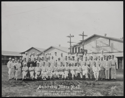
Crew of Anderson Brothers Mess Hall in Boulder City, Nevada: photographic print
Date
Archival Collection
Description
Image
City Hall decorated for Christmas, North Las Vegas, 1961 December 20
Level of Description
Archival Collection
Collection Name: North Las Vegas Library Photograph Collection on North Las Vegas, Nevada
Box/Folder: Folder 05
Archival Component
North Las Vegas City Hall and police station, 1964 May 17
Level of Description
Archival Collection
Collection Name: North Las Vegas Library Photograph Collection on North Las Vegas, Nevada
Box/Folder: Folder 05
Archival Component
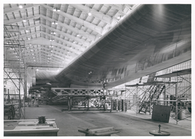
Photograph of the Hughes Flying Boat wing under construction, Culver City, California, June 1, 1945
Date
Archival Collection
Description
Image
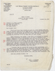
Letter from Hugh A. Shamberger (Carson City) to Colonel H. F. Clark (Las Vegas), December 11, 1951
Date
Archival Collection
Description
Shamberger advised the Water District to purchase the lands surrounding the Las Vegas Springs as well as other springs and wells in the area to protect its water sources in the future.
Text
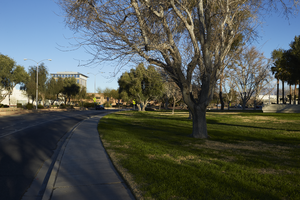
Landscaping along Civic Center Drive near City Hall in North Las Vegas, Nevada: digital photograph
Date
Archival Collection
Description
From the UNLV University Libraries Photographs of the Development of the Las Vegas Valley, Nevada (PH-00394). Part of the collection documents the entire 19 mile length of the north/south Eastern Avenue / Civic Center Drive alignment. This photograph was captured in the section of Civic Center Drive between Las Vegas Boulevard and Lake Mead Boulevard.
Image
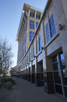
Exterior view of the North Las Vegas City Hall building in North Las Vegas, Nevada: digital photograph
Date
Archival Collection
Description
From the UNLV University Libraries Photographs of the Development of the Las Vegas Valley, Nevada (PH-00394). Part of the collection documents the entire 19 mile length of the north/south Eastern Avenue / Civic Center Drive alignment. This photograph was captured in the section of Civic Center Drive between Las Vegas Boulevard and Lake Mead Boulevard.
Image
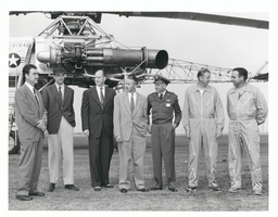
Photograph of Howard Hughes with XH-17 helicopter, Culver City, California, October 23, 1952
Date
Archival Collection
Description
Image
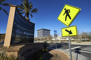
The City Centre Plaza sign on the corner of North McDaniel Street and Civic Center Drive with City Hall in background, looking northwest in North Las Vegas, Nevada: digital photograph
Date
Archival Collection
Description
From the UNLV University Libraries Photographs of the Development of the Las Vegas Valley, Nevada (PH-00394). Part of the collection documents the entire 19 mile length of the north/south Eastern Avenue / Civic Center Drive alignment. This photograph was captured in the section of Civic Center Drive between Las Vegas Boulevard and Lake Mead Boulevard.
Image
Aerial view of the Hughes Aircraft Culver City plant, approximately 1960-1969
Level of Description
Archival Collection
Collection Name: Howard Hughes Professional and Aeronautical Photographs
Box/Folder: Folder 05
Archival Component