Search Results
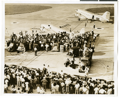
Lockheed 14 at Floyd Bennett Field, New York, 1938 July 10
Level of Description
Archival Collection
Collection Name: Howard Hughes Public Relations Photograph Collection
Box/Folder: Folder 05
Archival Component
Hughes Space and Communications Satellite Manufacturing B-Roll 2000, 2000 July 31
Level of Description
Archival Collection
Collection Name: Hughes Electronics Corporation Records
Box/Folder: Box 16, Digital File 00
Archival Component
Photograph of the Lockheed 14 aircraft at Floyd Bennett Field, New York, July 10, 1938
Date
Archival Collection
Description
Image
Hughes Productions and Hughes Tool Company regarding The Outlaw film rights, 1955 July 25 to 1962 April 17
Level of Description
Archival Collection
Collection Name: Howard Hughes Film Production Records
Box/Folder: Box 156 (Restrictions apply)
Archival Component
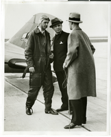
Photograph of Howard Hughes, Albert Lodwick, and unidentified man at Floyd Bennett Field, New York, April 21, 1936
Date
Archival Collection
Description
Image
Frederick Hugh Thatcher oral history interview summary, 2006 July 04
Level of Description
Archival Collection
Collection Name: Jarbidge, Nevada Community Archives Collection
Box/Folder: Box 01
Archival Component
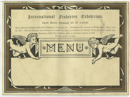
Langham Hotel menu, Tuesday, July 31, 1883
Date
Archival Collection
Description
Text

Map of California, Nevada, Utah, Colorado, Arizona & New Mexico, circa 1867
Date
Description
Image
Howard Hughes's around-the-world flight photographs, 1938
Level of Description
Scope and Contents
Materials depict the celebrations of Howard Hughes's circumnavigation flight in 1938. Along with a crew consisting of Harry Connor, Tom Thurlow, Richard Stoddart, and Ed Lund, Hughes flew the Super Electra on a global circumnavigation flight. On July 10, 1938, Hughes and the crew departed Floyd Bennett Field in New York and flew to Paris, France, Moscow, Russia, Omsk, Russia, Yakutsk, Russia, Fairbanks, Alaska, and Minneapolis, Minnesota before landing back in New York on July 14. The photographs primarily depict the parades thrown for Hughes after completion of the flight. The photographs also depict Hughes and his crew meeting with New York City Mayor Fiorello La Guardia at New York City Hall, the National Press Association, and crowds of onlookers who attended the plane's landings in various cities.
Archival Collection
Collection Name: Howard Hughes Public Relations Photograph Collection
Box/Folder: N/A
Archival Component
Hughes/Echostar Video News Release Corporate Announcement- New Master, 2002 March 07
Level of Description
Archival Collection
Collection Name: Hughes Electronics Corporation Records
Box/Folder: Box 14
Archival Component