Search Results
Weaver, Randy, New York Life, 1986 July 08
Level of Description
File
Archival Collection
Frank Mitrani Photographs
To request this item in person:
Collection Number: PH-00332
Collection Name: Frank Mitrani Photographs
Box/Folder: Box 20
Collection Name: Frank Mitrani Photographs
Box/Folder: Box 20
Archival Component
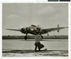
Photograph of Howard Hughes's plane taking off, Minneapolis, Minnesota, July 14, 1938
Date
1938-07-14
Archival Collection
Description
The black and white view of the Lockheed 14 aircraft taking off on a part of Howard Hughes' Around the World flight. Typed onto a piece of paper attached to the image: "Howard Hughes plane taking off from Minneapolis."
Image

Map of the territories of New Mexico, Arizona, Colorado, Nevada, and Utah, 1855
Date
1855
Description
29 x 36 cm. Relief shown by hachures. Prime meridians: Greenwich and Washington. "Entered according to act of Congress in the year 1855 by J.H. Colton & Co. in the Clerk's Office of the Dist. Office of the U.S. for the Southern. Dist. of New York." Hand colored. Decorative border. Atlas p. number in lower-right margin: 67. Shows routes of explorers, proposed railroad routes, wagon route, mail route, Indian reserves and mines. On verso: History and statistical view of Mexico. Original publisher: J.H. Colton.
Image
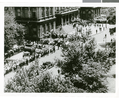
Photographs of crowds at Around-the-World-Flight Parade, New York City (N.Y.), July 15, 1938
Date
1938-07-15
Archival Collection
Description
Crowd at a parade in New York City celebrating the completion of Howard Hughes' Around-the-World Flight!
Image
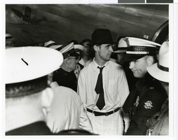
Photograph of Howard Hughes next to an airplane and surrounded by crowds at Houston Airport, Texas, July, 30, 1938
Date
1938-07-30
Archival Collection
Description
Howard Hughes (in hat) surrounded by crowd at Houston Airport, Houston, Texas.
Image
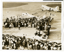
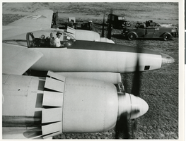
Photograph of the Lockheed 14 aircraft at Floyd Bennett Field, New York, July 10, 1938
Date
1938-07-10
Archival Collection
Description
The black and white view of the Lockheed 14 aircraft at Floyd Bennett Field in New York. Typed onto a piece of paper attached to the image: "Scene at Floyd Bennett Airport this evening shortly before the big Lockheed special monoplane New York World's Fair 1939 took off on a transatlantic flight to Paris, carrying Howard Hughes an a crew of four."
Image
Photograph of Howard Hughes in the cockpit of the XF-11 preparing for his first test flight in Culver City, California July 7, 1947
Date
1947
Archival Collection
Description
Howard Hughes sits in the cockpit of the XF-11, a reconnaissance plane that Hughes built and designed in conjunction with Air Materiel Command engineers. Hughes is preparing for his first test flight in Culver City, California July 7, 1947.
Image
Lockheed 14, Floyd Bennett Field, New York, 1938 July 10
Level of Description
File
Archival Collection
Howard Hughes Public Relations Photograph Collection
To request this item in person:
Collection Number: PH-00373
Collection Name: Howard Hughes Public Relations Photograph Collection
Box/Folder: Folder 06
Collection Name: Howard Hughes Public Relations Photograph Collection
Box/Folder: Folder 06
Archival Component

Map of California, Utah, Nevada, Colorado, New Mexico and Arizona, 1864
Date
1864
Description
'Johnson's California, also Utah, Nevada, Colorado, New Mexico, and Arizona, published by A.J. Johnson, New York.' 'Entered according to Act of Congress in the Year 1864, by A.J. Johnson in the Clerks Office of the District Court of the United States for the Southern District of New York.' Atlas page numbers in upper margin: 66-67. Relief shown by hachures. Prime meridians: Greenwich and Washington, D.C. Shows proposed railroads, locations of Indian tribes, natural features, counties, mines, mail routes, trails and routes of exploring expeditions. On verso: History and statistics of Mexico and Central America and statistics of national finances and the Post Office of the United States, 1860. Scale [ca. 1:3,484,800. 1 in. to ca. 55 miles] (W 123°--W 103°/N 42°--N 32°)
Text