Search Results
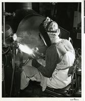
Photograph of new atomic-hydrogen welding process, Hughes Tool Company, Houston, Texas, circa 1929
Date
Archival Collection
Description
Image
Hughes Space and Communications Satellite Manufacturing B-Roll 2000, 2000 July 31
Level of Description
Archival Collection
Collection Name: Hughes Electronics Corporation Records
Box/Folder: Box 16, Digital File 00
Archival Component
New York-New York Hotel & Casino: first floor interior load requirements, 1995 July
Level of Description
Archival Collection
Collection Name: Donna Silva Lighting Design Plans
Box/Folder: Roll 13
Archival Component
New York-New York Hotel and Casino 9-11 Heroes Tribute Collection
Identifier
Abstract
The New York-New York Hotel and Casino 9-11 Heroes Tribute Collection consists of materials from the "Heroes of 9-11" display that was at the New York-New York Hotel and Casino in Las Vegas, Nevada from 2001 to 2012. The materials primarily consist of more than 5,000 t-shirts left at the memorial by visitors to Las Vegas, mostly from fire departments and law enforcement agencies from around the United States. Visitors left shirts and other items at the memorial as a sign of respect for the men and women who died during the terrorist attacks in New York City and Washington, D.C. on September 11, 2001. The collection also houses memorabilia and other items left at the memorial, including flags, hats, pins, buttons, flowers, and embroidered emblems and insignias. The materials also contain documentation of the memorial, including promotional and press materials, video recordings from the news media, photographs, and newspaper articles.
Archival Collection
Del Webb's Sahara Boardwalk-Atlantic City, New Jersey
Level of Description
Archival Collection
Collection Name: Martin Stern Architectural Records
Box/Folder: N/A
Archival Component
Harrah's Marina Hotel Casino: Atlantic City, New Jersey
Level of Description
Archival Collection
Collection Name: Martin Stern Architectural Records
Box/Folder: N/A
Archival Component
"The Meadowlands and New York City's Harness Racing Industry", 1987
Level of Description
Archival Collection
Collection Name: Eugene Martin Christiansen Papers
Box/Folder: Box 049
Archival Component
Coalition for Casino Gambling: plan for New York City, undated
Level of Description
Archival Collection
Collection Name: Eugene Martin Christiansen Papers
Box/Folder: Box 163
Archival Component
New York City Council news reports and correspondence, 1990
Level of Description
Archival Collection
Collection Name: Eugene Martin Christiansen Papers
Box/Folder: Box 163
Archival Component
The New Superstar Commune: Las Vegas, Cavalier, 1975 July 24
Level of Description
Archival Collection
Collection Name: Arnold Shaw Papers
Box/Folder: Box 14
Archival Component