Search Results
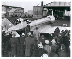
Photograph of Howard Hughes leaving the Northrop Gamma Racer, Newark, New Jersey, January 13, 1936
Date
1936-01-13
Archival Collection
Description
Howard Hughes leaving the cockpit of a Northrop Gamma, surrounded by a crowd at Newark New Jersey Airport. Hughes set a coast-to-coast speed record. A bank of microphones and a movie camera are seen beside the plane.
Image

Map of California and territories of New Mexico and Utah, circa 1861
Date
1859 to 1862
Description
'Compiled, drawn, and engraved under the supervision of J.H. Colton and A.J. Johnson.' Relief shown by hachures and spot heights. Scale [ca. 1:3,041,280]. 1 in. to approx. 48 miles (W 124°--W 103°/N 42°--N 31°). Hand colored
Prime meridians: Greenwich and Washington
Plates 54 & 55 removed from Johnson's New illustrated family atlas of the world, with descriptions geographical, statistical and historical ... New York, 1862
Title page of atlas.
Prime meridians: Greenwich and Washington
Plates 54 & 55 removed from Johnson's New illustrated family atlas of the world, with descriptions geographical, statistical and historical ... New York, 1862
Title page of atlas.
Image
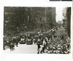
Photograph of a parade procession, New York, July 15, 1938
Date
1938-07-15
Archival Collection
Description
A view looking down Broadway during the parade procession to celebrate Howard Hughes' completion of his round-the-world flight.
Image
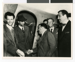
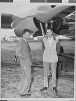
Howard Hughes and co-pilot Joseph Bartles at the controls of their Lockheed Constellation after landing at LaGuardia Field in New York City, 1946 February 15
Level of Description
File
Archival Collection
Howard Hughes Public Relations Photograph Collection
To request this item in person:
Collection Number: PH-00373
Collection Name: Howard Hughes Public Relations Photograph Collection
Box/Folder: Folder 20
Collection Name: Howard Hughes Public Relations Photograph Collection
Box/Folder: Folder 20
Archival Component
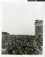
Photograph of a crowd of people awaiting the arrival of Howard Hughes, New York, July 14, 1938
Date
1938-07-14
Archival Collection
Description
The black and white view of a crowd of people awaiting the arrival of Howard Hughes in his Lockheed 14 aircraft at Floyd Bennett Airport, New York. This final landing for Hughes marked the end of his Round The World flight.
Image
Photograph of Howard Hughes with Fiorello La Guardia and Grover Whalen, New York, July 12, 1938
Date
1938-07-12
Archival Collection
Description
Howard Hughes (wearing hat) receives congratulations from Mayor Fiorello La Guardia at Floyd Bennett Airport in Brooklyn. The gentleman wearing a polka dot bow tie, standing behind the mayor is Grover Whalen. Mr. Whalen was president of the 1939 New York World's Fair.
Image
Photograph a crowd awaiting watching Howard Hughes land, New York, July 14, 2013
Date
1938-07-14
Archival Collection
Description
The black and white view Mayor Laguardia and Grover Whelen watched Howard Hughes land in his Lockheed 14 aircraft at Floyd Bennett Field, New York. Typed onto a piece of paper attached to the image: "Mayor Laguardia (left) and Grover Whelen looking skyward as they see the approaching Howard Hughes and his globe girdlers complete A Round The World flight, 7-24-38. (Press Association)."
Image
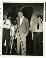
Photograph of Howard Hughes at a press conference beside his Douglas DC-3, New York, April, 1947
Date
1947-04
Archival Collection
Description
Howard Hughes giving a news Conference beside his airplane after landing in New York. This was his first flight after the nearly fatal XF-11 prototype crash in 1946.
Image
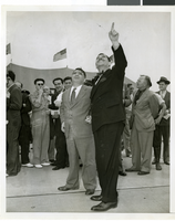
Photograph of Howard Hughes after hearing, Culver City, California, August 15, 1947
Date
1947-08-15
Archival Collection
Description
A view of Howard Hughes attending an informal press conference in Culver City, California, after Hughes left the Senate War Investigating Subcommittee hearing in Washington.
Image

Photograph of Howard Hughes and Grover Whalen at Floyd Bennett Airfield, New York, July 14, 1938
Date
1938-07-14
Archival Collection
Description
A view of Howard Hughes and Grover Whalen at Floyd Bennett Airfield in New York. Description printed on photograph's accompanying sheet of paper: "Howard Hughes leaving Floyd Bennett Airport after completing a round the world flight with four companions. He is leaving with Grover Whalen (Left in picture) 7-14-38. (Press Association)."
Image