Search Results
Grover Whalen and Howard Hughes during a parade that celebrated Hughes's completion of his around-the-world flight in New York City, 1938 July 15
Level of Description
Archival Collection
Collection Name: Howard Hughes Public Relations Photograph Collection
Box/Folder: Folder 12
Archival Component
Howard Hughes and his crew at a parade for Howard Hughes after he completed his around-the-world flight in New York, 1938 July 15
Level of Description
Archival Collection
Collection Name: Howard Hughes Public Relations Photograph Collection
Box/Folder: Folder 10
Archival Component
Howard Hughes and his crew at a parade for Howard Hughes after he completed his around-the-world flight in New York, 1938 July 15
Level of Description
Archival Collection
Collection Name: Howard Hughes Public Relations Photograph Collection
Box/Folder: Folder 10
Archival Component
Howard Hughes and his crew at a parade for Howard Hughes after he completed his around-the-world flight in New York, 1938 July 15
Level of Description
Archival Collection
Collection Name: Howard Hughes Public Relations Photograph Collection
Box/Folder: Folder 10
Archival Component
Howard Hughes and his crew at a parade for Howard Hughes after he completed his around-the-world flight in New York, 1938 July 15
Level of Description
Archival Collection
Collection Name: Howard Hughes Public Relations Photograph Collection
Box/Folder: Folder 10
Archival Component
Howard Hughes and his crew at a parade for Howard Hughes after he completed his around-the-world flight in New York, 1938 July 15
Level of Description
Archival Collection
Collection Name: Howard Hughes Public Relations Photograph Collection
Box/Folder: Folder 10
Archival Component
Howard Hughes emerging from his airplane after landing in New York, 1947 April
Level of Description
Archival Collection
Collection Name: Howard Hughes Professional and Aeronautical Photographs
Box/Folder: Folder 02, Flat File 01
Archival Component
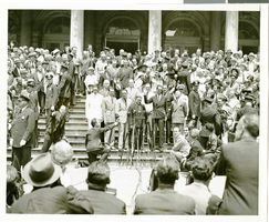
Photograph of Howard Hughes and crew posing for photographs outside of City Hall, New York City, July 15, 1938
Date
Archival Collection
Description
Image

Map of California, Utah, Nevada, Colorado, New Mexico and Arizona, circa 1867
Date
Description
Image
Hughes H-1 Racer photographs, 1937
Level of Description
Scope and Contents
Materials depict the Hughes H-1 Racer in 1937. The photographs primarily depict Howard Hughes standing with the plane or in the plane's cockpit. The plane was designed by Glenn Odekirk and built by Hughes Aircraft Company in 1935, the first plane produced by the company. Hughes broke several records in the H-1, including the landplane speed record in 1935. In 1937, Hughes broke his own transcontinental speed record by flying from Los Angeles, California to New York City, New York in 7 hours, 28 minutes. Despite its speed, Hughes was unable to sell the H-1 to the U.S. military.
Archival Collection
Collection Name: Howard Hughes Public Relations Photograph Collection
Box/Folder: N/A
Archival Component