Search Results

City map of Las Vegas, 1973
Date
1905-05-26
Description
Color; 55 x 45 cm., on sheet 95 x 47 cm., folded to 24 x 10 cm. Panel title: Las Vegas city map. Copyright held by Cardinal Publishing Company. Relief shown by hachures. Includes illustrations and advertisements. Index, text, illustrations, advertisements, and map of "Lake Mead National Recreation Area, lower basin section" on verso. Original publisher: Cardinal Publishing Company.
Image
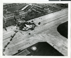
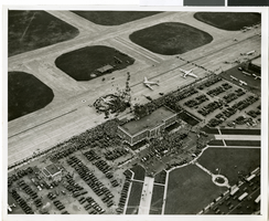
Photograph of the landing of Howard Hughes' Lockheed 14 aircraft, New York, July 14, 1938
Date
1938-07-14
Archival Collection
Description
The black and white, aerial view of Howard Hughes' Lockheed 14 aircraft after performing its final landing on the Round the World flight at Floyd Bennett Airport, New York. Typed onto a piece of paper attached to the image: "Crowds welcome round the world flyers at Floyd Bennett Field 7/14/38. (Press Association)"
Image
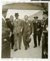
Photograph of Howard Hughes and Grover Whalen at Floyd Bennett Airfield, New York, July 14, 1938
Date
1938-07-14
Archival Collection
Description
A view of Howard Hughes being escorted by Grover Whalen and several guards at Floyd Bennett Airfield.
Image
Report: "Marketing Casino Gambling and a Local Lottery in New York City" by the Council of the City of New York for the Committee on Economic Development, 1991
Level of Description
File
Archival Collection
Eugene Martin Christiansen Papers
To request this item in person:
Collection Number: MS-00561
Collection Name: Eugene Martin Christiansen Papers
Box/Folder: Box 163
Collection Name: Eugene Martin Christiansen Papers
Box/Folder: Box 163
Archival Component

Map of California, Utah, Nevada, Colorado, New Mexico and Arizona, 1864
Date
1864
Description
'Johnson's California, with Utah, Nevada, Colorado, New Mexico, and Arizona, published by Johnson and Ward.' 'Entered according to Act of Congress in the Year 1864 by A.J. Johnson in the Clerks Office of the District Court of the United States for the southern district of New York.' Atlas page numbers in upper margin: 66-67. This is probably plate 67 from Johnson's New Illustrated Family Atlas, published in New York by Johnson & Ward in 1864. Shows natural features, locations of Indian tribes, proposed railroad routes, routes of explorers, trails, county boundaries and populated places ; "." ; Relief shown by hachures ; Prime meridians: Greenwich and Washington ; In top margin: 66-67 ; Hand colored ; On verso: Historical and statistical view of Mexico and central America (p. 79) and Historical and statistical view of the United States, 1860 (p. 78) Scale [ca. 1:3,484,800]. 1 in. to ca. 55 miles (W 124°--W 102°/N 42°--N 32°)
Text
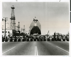
Photograph of police escorting the fuselage of Hughes Flying Boat, San Pedro, California, June 15, 1946
Date
1946-06-15
Archival Collection
Description
Police escort lined up in front of Hughes Flying Boat on Roosevelt Highway in San Pedro, California, as it was being moved from Culver City to Terminal Island in Long Beach.
Image
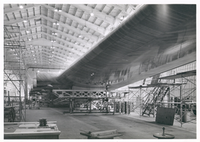
Photograph of the Hughes Flying Boat wing under construction, Culver City, California, June 1, 1945
Date
1945-06-01
Archival Collection
Description
View of construction of one of the wings of the Hughes Flying Boat in a hangar at the Hughes Aircraft Company, June 1, 1945. Scaffolding is seen underneath the wing.
Image
Photograph of the landing of Howard Hughes' Lockheed 14 aircraft, New York, July 14, 1938
Date
1938-07-14
Archival Collection
Description
The black and white, aerial view of Howard Hughes' Lockheed 14 aircraft performing its final landing on the Round the World flight at Floyd Bennett Airport, New York. Typed onto a piece of paper attached to the image: "Journey's End for World Fliers! Floyd Bennett Airport, N. Y. ---- The "World's Fair 1939.," Howard Hughes' silver monoplane, shown on the ground just after it landed here, concluding an amazing globe-girdling flight in total elapsed time of 3 days, 19 hours, 10 seconds. A crowd of officials surround the plane. Credit Line (ACME) 7/14/38."
Image

Map of the territories of New Mexico, Arizona, Colorado, Nevada, and Utah, 1855
Date
1855
Description
29 x 36 cm. Relief shown by hachures. Prime meridians: Greenwich and Washington. "Entered according to act of Congress in the year 1855 by J.H. Colton & Co. in the Clerk's Office of the Dist. Office of the U.S. for the Southern. Dist. of New York." Hand colored. Decorative border. Atlas p. number in lower-right margin: 67. Shows routes of explorers, proposed railroad routes, wagon route, mail route, Indian reserves and mines. On verso: History and statistical view of Mexico. Original publisher: J.H. Colton.
Image
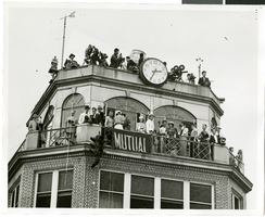
Photograph of people atop a tower awaiting the arrival of Howard Hughes, New York, July 14, 1938
Date
1938-07-14
Archival Collection
Description
The black and white view of a crowd of people, possibly including reporters and members of the press, standing atop a tower as they wait for the arrival of Howard Hughes in his Lockheed 14 aircraft at Floyd Bennett Airport, New York. This final landing for Hughes marked the end of his Round The World flight.
Image