Search Results
Howard Hughes giving an interview in front of his converted B-23 bomber at LaGuardia Field following his transcontinental flight from Culver City to New York, 1946 September 12
Level of Description
Archival Collection
Collection Name: Howard Hughes Public Relations Photograph Collection
Box/Folder: Folder 22
Archival Component
Hughes Aircraft Stock Footage for the Discovery Channel- Flying Boat Howard Hughes Culver City Plant-Camera Original, 1997 December
Level of Description
Archival Collection
Collection Name: Hughes Electronics Corporation Records
Box/Folder: Box 11
Archival Component

Photograph of Howard Hughes in the cockpit of the XF-11 preparing for his first test flight in Culver City, California July 7, 1947
Date
Archival Collection
Description
Image
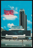
Harrah's at Trump Plaza in Atlantic City, New Jersey: postcard
Date
Archival Collection
Description
Image
Hughes Aircraft Retirees Association Records
Identifier
Abstract
The Hughes Aircraft Retirees Association (HARA) Records (1940-2018) contain a variety of publications, organizational charts and technical reports, audiovisual materials, and photographs related to Hughes Aircraft Company and Hughes Electronics. These materials were gathered by members of the Hughes Aircraft Retirees Association, a social organization for retirees of Hughes Aircraft Company including Boeing, Raytheon, and Kinecta.
Archival Collection
Proposed Hotel, Atlantic City Convention Center: Atlantic City, New Jersey, 1976 November 22
Level of Description
Archival Collection
Collection Name: Martin Stern Architectural Records
Box/Folder: N/A
Archival Component
Hughes/Echostar Video News Release Corporate Announcement- New Master, 2002 March 07
Level of Description
Archival Collection
Collection Name: Hughes Electronics Corporation Records
Box/Folder: Box 14
Archival Component
Global Works Hughes Electronic Corporation Corporate Runner New AO, 2000 October 23
Level of Description
Archival Collection
Collection Name: Hughes Electronics Corporation Records
Box/Folder: Box 16
Archival Component